
|
COOL START - Although temperatures are currently in the mid 50s, it will be a rather warm day today with highs nearing 80° this afternoon. We expect clouds to slowly diminish by the afternoon. It will also be very windy with a southwest wind of 20 mph. A cold front arrives tomorrow morning in dry fashion, and we will continue to mention mostly sunny skies. This time, afternoon highs will be in the low 70s with morning lows in the mid 50s, still very slightly above average for early November. While North Texas enjoys comfortable weather, parts of Dixie Alley will face the threat of some severe weather today with an "enhanced risk" (risk 3 of 5) of severe storms for much of Mississippi and parts of Tennessee and Alabama, with the standard slight risk surrounding those areas. 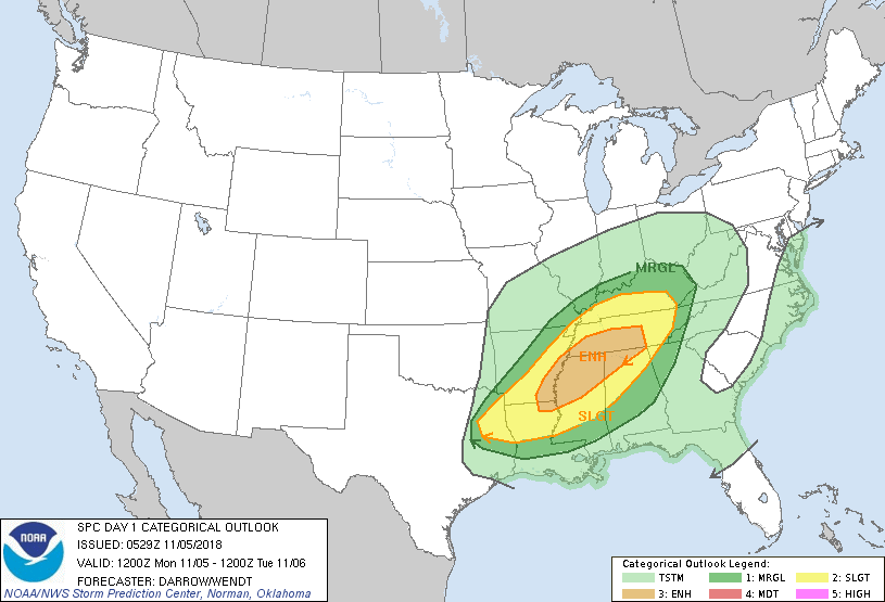 All modes of severe weather will be possible, including the risk of damaging winds, large hail, and a few tornadoes. This threat will start in the evening, and continue through the nighttime. WEDNESDAY THROUGH FRIDAY - The southern flank of a cold front reaches down to North Texas, and we could see a few scattered showers and thunderstorms during the middle of the workweek as a result. The best chance of one spot getting wet will be in the 30 percent bracket, and nothing should be widespread. Moisture will persist into Thursday, so we will mention even greater rain chances there. Highs will be in the mid 60s on both days with mostly cloudy skies. An upper high pressure will do a sufficient job of pushing cold air southward, so we will begin to cool down on a noticeable level by Friday. Highs will be in the low 50s with morning lows in the mid to upper 30s. We could see some frost in the morning, but temperatures will not be cold enough for a widespread freeze. THE WEEKEND - Not much change. We will stick with a dry and pleasant weekend with highs in the upper 50s with morning lows in the low 40s with a mostly sunny sky. NEXT WEEK - Global models have been consistently showing the risk for some "winter mischief" for parts of North Texas with a surface front moving down from the north. That would mean a chance of snow with freezing temperatures early Monday morning. However, the models have been rather bullish on that idea, so we will continue to leave a dry forecast with highs in the mid to upper 50s with a mostly sunny sky. Based on latest trends, our first freeze of the season likely comes November 14. See the Texas Weather Discussion Video for more details. 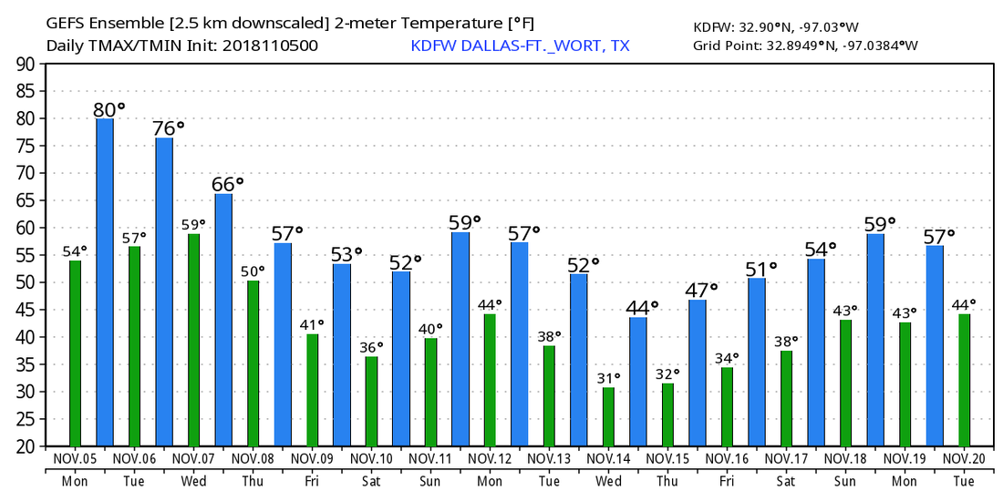 TROPICS - The Atlantic Basin remains very quiet, and will continue to do so over the next week.
|
Archives
March 2023
Categories |
 RSS Feed
