
|
NO ISSUES THIS MORNING - The only thing we might have this morning is a few morning showers over parts of eastern Texas... those will dissipate by the afternoon, and the day will be mostly cloudy and warm with a high in the upper 70s. THE EVENING - A deep surface low will be to the north of the Texas Panhandle, supported by a strong upper trough with favorable wind fields. The overall large scale pattern favors severe weather for the region, but, it will be the small scale features that will determine our overall severe weather risk. Instability values will rise during the evening, and surface-based CAPE values will be in the 2000-2500 j/kg range by the time storms develop. Shear profiles favor severe storms as well, making for a "low instability, high shear event". SPC has now put most of the DFW metroplex under the standard "slight risk", with an "enhanced risk" for much of the Ark-La-Tex region. 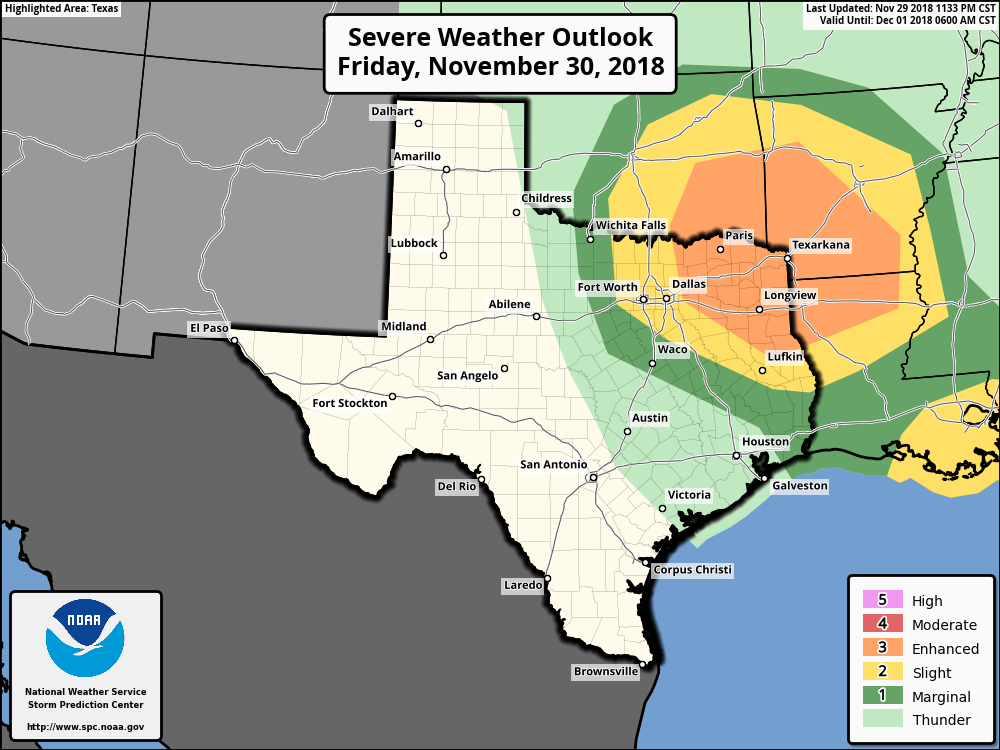 It is imperative to remember to not get hung up on these map lines and terms; storms don’t know about these lines and terms. This is just a simple guideline to let you know where the greatest potential for severe weather is today.
PLACEMENT - While all of North Texas has a risk of severe weather today, the highest risk of all severe weather modes will be confined to the north of I-20 and the east of I-35. This is where the best combination of shear, lift, and instability will be found. There will certainly be the potential for a tornado or two for the DFW Metroplex this evening, but the odds are just a little bit lower down here. TIMING - Expect the wave of thunderstorms to develop and move through the metroplex at around 5-10 PM. The best chance of severe weather will come by the early evening hours during the peak of the daytime heating process. The one thing we do not want is breaks in the clouds as it will only increase our instability and chances of seeing severe storms later this evening. We will need to remain alert for the rest of the day. THREATS - All modes of severe weather will be possible, including the potential for large hail, damaging winds, and a few tornadoes. A strong/violent tornado or two can’t be ruled out, especially in the enhanced risk area. RAIN - Rain amounts of a quarter of an inch or more is possible in some spots, so no flooding issues are expected. PLAN OF ACTION - Be sure you have a robust, reliable way of getting severe weather, which includes a NOAA Weather Radio and a good smartphone app like this one. Identify the safe place in your home, and make sure your safe place includes hard sole shoes, helmets, and air horns in case you are in trouble. THIS IS IMPORTANT!!!! - Readers they have been with us for a long time know we are exclusively weather “with a common sense approach”, meaning that we are exclusively a “no hype zone”. You will hear lots of things on social media throughout the day. There is absolutely no reason to be alarmed or panicked. This is our late severe weather season in Texas, and severe weather risks like this are very normal. We are know for being prepared for normal days like this, so just be sure you have a plan in place. Keep an eye on our Twitter page and blog for more details. THE WEEKEND - This weekend will be very pleasant with mostly sunny skies. Highs will be in the mid to upper 60s throughout the weekend. NEXT WEEK - A strong cold front comes through early Monday morning which will cause next week to be mostly dry and sunny with highs down in the upper 40s to mid to upper 50s. A storm system emerges from the Pacific Friday, and that will be our next chance of widespread rain for the state. See the Texas Weather Discussion Video for more details. TROPICS - The 2018 Atlantic Hurricane Season ends today. We have had a total of 15 named storms. 8 were hurricanes and two were major hurricanes. We were only slightly above average this year. The names Florence and Michael will likely be retired due to their significant impacts to life and property. |
Archives
March 2023
Categories |
 RSS Feed
