
|
CLOUDY AND CHILLY - Temperature are in the low to mid 50s this morning with a mostly overcast sky. Clouds will hang strong across North Texas today with rain at times mainly during the afternoon and evening hours. On Friday, some lingering showers is likely mainly during the morning hours as the moisture starts to get pushed to the north. We won't warm much at all during the day. We will hover in the low 50s throughout the afternoon, with some places falling to the upper 40s. And, temperatures will start in the low 40s Friday morning. Friday will be a chilly, blistery day as temperatures will stay in the low 50s with a north 10-20 mph wind. The sun should be out at times, though. THE WEEKEND - Mornings will be very cold; we project a low between 30 and 36 degrees both Saturday and Sunday morning with frost likely in most spots. Some places could see their first freeze of the season. The sky will be sunny on Saturday with highs only in the upper 40s. Clouds will increase Sunday with afternoon highs in the mid 40s. NEXT WEEK - A very cold rain is likely throughout the day on Monday with highs struggling to get out of the mid 40s throughout the day. Rain will end very early Tuesday morning, but Tuesday will likely be a raw, cloudy day with a brisk north wind of 12-20 mph, so it will feel much, much colder. Then, Wednesday morning will feature lows down in the upper 20s for some spots, right at the record temperature for November 14. The day will feature a mix of sun and clouds with highs in the upper 40s. The rest of the week and next weekend will be mostly dry with a slow warming trend... See the Texas Weather Discussion Video for more details. 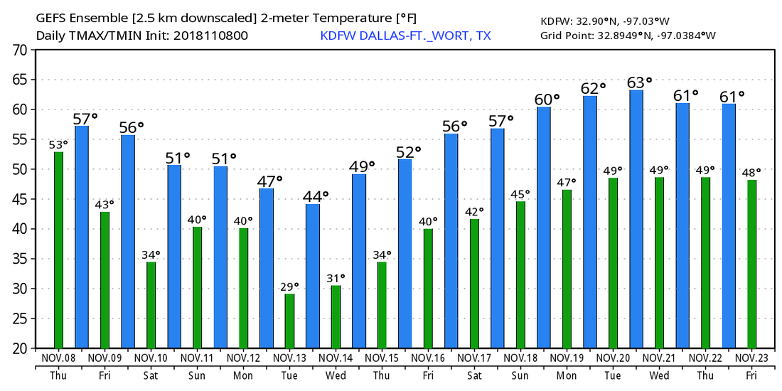 |
Archives
March 2023
Categories |
 RSS Feed
