
|
COLD IS THE WORD - Just about everyone in the region of North Texas should experience below freezing temperatures sometime this week. But for now, light rain is still moving east through North Texas, and will continue throughout most of the afternoon. For now, winter weather is not expected, although there is a very small chance of some of the light rain turning into a light wintery mix in some spots, but I wouldn't count on it. If the forecast continues to verify, most places will become dry during the late afternoon/evening. With the cold front coming through, temperatures will go the wrong way throughout the day. We start in the low 40s now, but we will be closer to the upper 30s by the afternoon. MIDWEEK - We will turn very cold tonight/tomorrow morning with many places seeing a hard freeze in North Texas. Tomorrrow's forecast low is around 28 degrees, Wednesday's is around 27 degrees, which will beat the old record low of 29 degrees set in November 14, 1959. Both days will feature a mostly sunny sky with highs in the low to mid 40s, but it will feel colder than that with a northerly wind creating a wind chill. THURSDAY/FRIDAY - We start to warm substantially after Thursday. We will still have a freeze on Thursday, but we will warm to the mid to upper 50s with a mostly sunny sky. We will actually start Friday above freezing with highs in the low 60s. Each day will feature a mostly sunny sky. THE WEEKEND - Saturday and Sunday will be dry, cool days featuring mostly sunny skies with highs in the 56 to 63 degree range and lows in the low 40s. NEXT WEEK - The first half of Thanksgiving Week will be mostly cloudy and rainy with highs in the upper 50s to low 60s.... See the Texas Weather Discussion Video for more details. 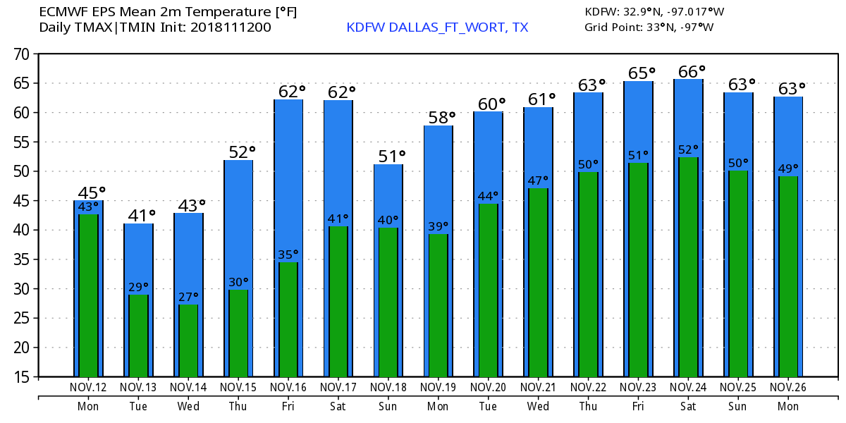 TROPICS - There is a disturbance east of the Bahamas that has a high chance of developing to tropical depression or storm within the next few days. This will most likely curve out into the Atlantic, posing no threat to the US.
|
Archives
March 2023
Categories |
 RSS Feed
