
|
We will be watching new model data pouring in over the next few hours into tomorrow morning, with the highest interest in developments Friday, when severe thunderstorms are becoming increasingly likely region-wide over the North Texas area. No doubt the synoptic scale suggests that it could be a bigger severe weather afternoon/evening than what we have planned for, with a deep surface low in the Texas Panhandle supported by an upper trough with very strong wind fields. We expect a very light batch of a few showers in East Texas Friday morning as moisture continues to surge northward, generally happening within the 6-12AM time frame. These will be elevated in nature, and no severe weather is expected from these showers. However, the main action should come during the afternoon and evening hours, generally between 5:00 PM and 10:00 PM. The one thing that keeps me interested on this potential tomorrow is how quickly the data elevated the potential for severe storms; some of the model guidance now suggesting shear values could exceed 50 knots by mid-evening... 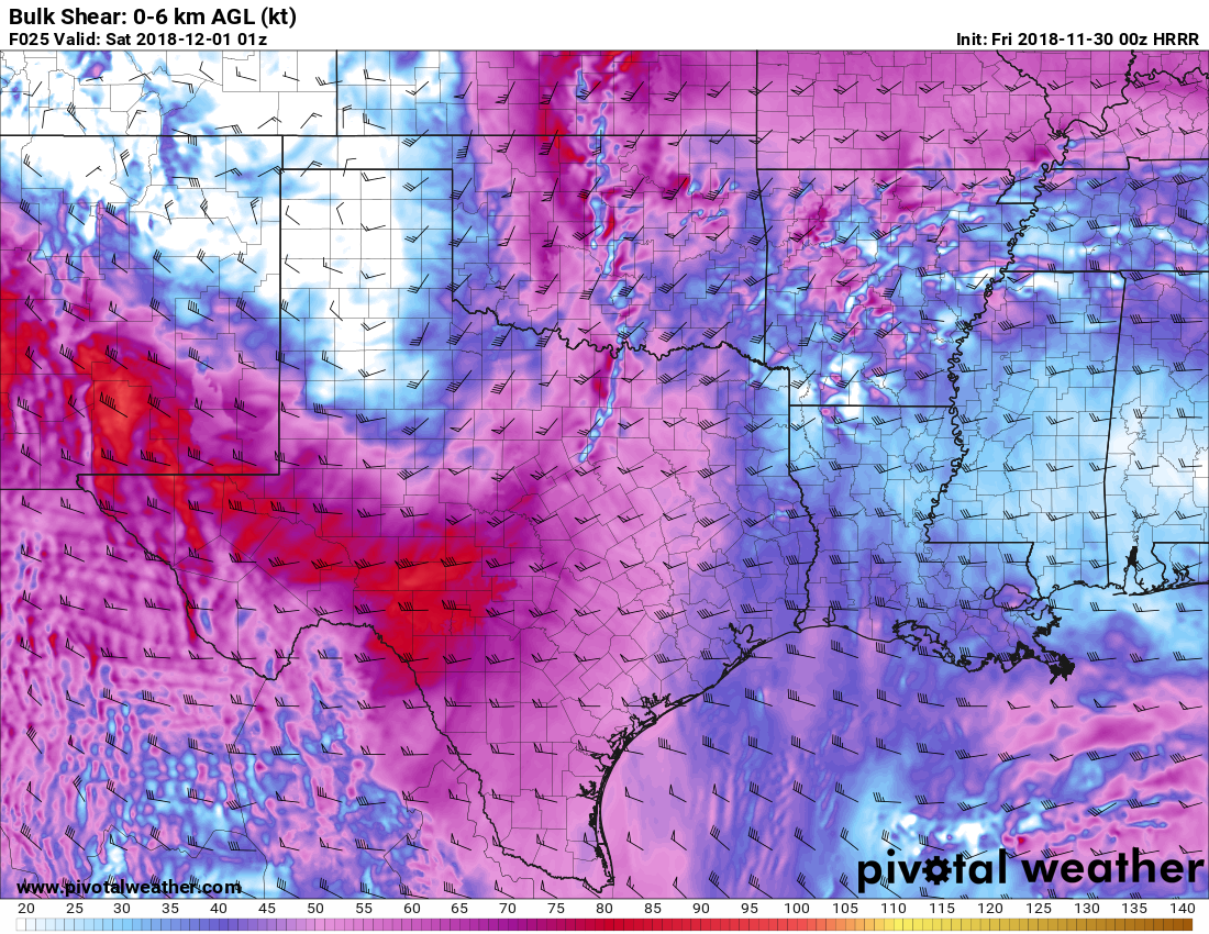 This will create a "moderately unstable, high shear" type atmosphere with decent enough buoyancy with nothing in the way of a capping inversion. Storms should develop during the peak of the daytime heating process, with afternoon highs in the upper 70s. Based on severe weather parameters such as very high bulk shear, lapse rates, moderate instability, and the lack of convective inhibition, storm initiation will start to occur around the 4:00-4:45 timeframe and intensify quickly with all modes of severe weather possible, including the potential of VERY large hail, damaging wind gusts, and the potential for a few tornadoes. Additionally, there is potential that we could see even a strong/violent tornado or two.
If these trends continue, while not likely, I would not be surprised at all if the guys at SPC put a portion of North Texas under a "moderate risk" (level 4 of 5) of severe storms sometime tomorrow. Risk upgrade or not, it looks like a fairly active evening with potential for some severe storms. PLACEMENT - With the new data, it looks like the best combination of shear instability could POTENTIALLY wind up in North Texas, but the bottom line is, the entire region of Northeast Texas will see some risk of severe storms. Additionally, it is very wise to note that we don't exactly know how the parameters will come into play during the afternoon. There is no need to be anxious or overly scared or concerned, but just be prepared SHOULD anything severe happens. Severe weather situations like this are typical during our late severe weather season, so just be prepared. PLAN OF ACTION - Be sure you have a robust, reliable way of getting severe weather watches and warnings; a NOAA Weather Radio is the standard baseline. and a good app like this one is the best way to go. Be sure to identify the safe place in your home, away from windows, and be sure everyone that lives there knows where it is. Make sure you have helmets for individuals, hard-sole shoes, and preferably an airhorn in case you need help. Be sure to follow ApexStorm on Twitter so you can watch our live feed during the events @apex_dfw_wx and @apexstormdfw. Also make sure you follow our website throughout the day for synoptic scale updates. I will have the new discussion and Texas Weather Discussion Video posted bright and early tomorrow morning... Donovan Neal Lead Forecaster Severe Weather Specialist Lead of the Band Forecast Company |
Archives
March 2023
Categories |
 RSS Feed
