
|
FEELS NICER THIS MORNING - After having morning lows in the 20s-30s at the beginning of the week, we have warmed nicely this morning with most communities in the low to mid 50s. Today will be mostly sunny and mild with highs in the mid 70s during the afternoon. FRIDAY STORM POTENTIAL - A threat of severe weather exists for some parts of North and Northeast Texas and points to the northeast as a potent storm system continues to move to the east. The SPC has the "enhanced risk" (level 3 of 5) of severe storms defined for the northeast corner of the state near Paris, Texarkana, and just to the north of Longview. The standard "slight risk" (level 2 of 5) of severe storms include areas to the east of I-35 near Dallas, Plano, Waxahachie, Corsicana, and points to the east. A "marginal risk" (level 1 of 5) risk of severe storms encompasses the rest of North Texas. 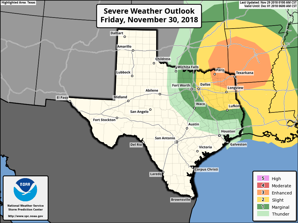 IMPACT - For those that are closer to the enhanced risk area, all modes of severe weather is possible, including the potential for a few tornadoes at times. Hail can be expected at times as well. Closer to home, we will watch the few storms that develop for severe potential, but it does look like key parameters and overall coverage of the storms could be out of fruition for a big severe weather issue. TIMING - Wet weather is likely in the broad 12 hour window of 4:00 PM - 4:00 AM tomorrow afternoon and evening. It definitely won't rain all 12 hours, but a few storms during that time period is likely. However, the latest runs of the NAM (North American Mesoscale) model shows most of the activity staying to the east of the DFW Metroplex. Don't expect much impacts for DFW, if any, and most of the day should be dry with a mix of sun and clouds. Highs will be in the mid 70s. THE WEEKEND - Look for basically perfect weather conditions this weekend with a pleasant sky and cool nights. Highs will be near 70 on Saturday, followed by mid 60s on Sunday. NEXT WEEK - An upper high in the high plains will bring colder air to the state starting Monday with highs starting in the mid 50s. We get a tad cooler throughout the week, but we still maintain mostly sunny skies. Our next wave towards Friday and Saturday will bring more rain to the state Friday night and Saturday during the day. At this time, this does not look like a severe weather issue at all. See the Texas Weather Discussion Video for more details. 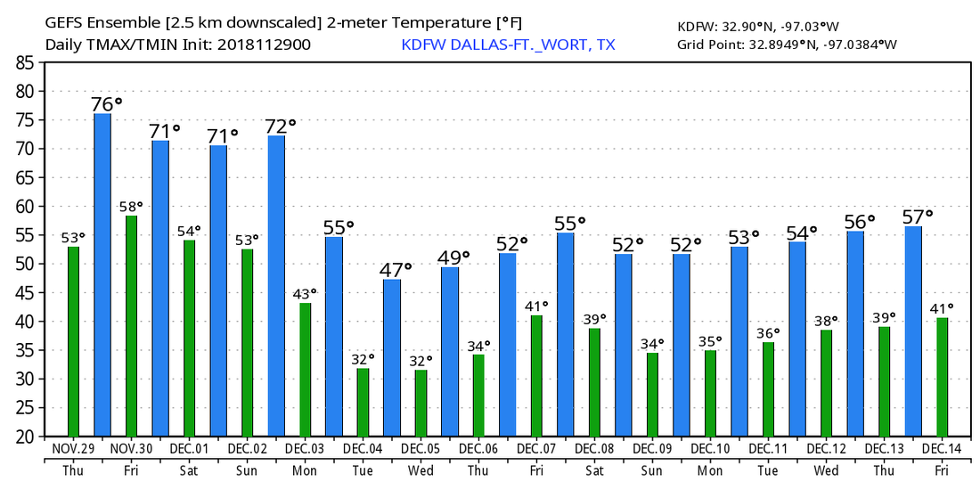 |
Archives
March 2023
Categories |
 RSS Feed
