
|
FAIRLY DRY MORNING - Not much to see on the radar this morning, but we do have a few areas of patchy drizzle as you head to work and school this morning. A few showers here and there can't be ruled out throughout the day as it will stay mostly overcast today, but the chance of any one spot getting wet is only in the 20 percent bracket. Highs will stay in the low 80s today. The sun might try to come out at times. Then tomorrow, we dry out with a mix of sun and clouds this time. We could see our very last push to 90° for a very long time. Most places will stay in the 80s. WEDNESDAY THROUGH FRIDAY - The long awaited cold front makes its appearance early Wednesday morning, bringing cooler temperatures and more frequent rain chances to the area. It will also bring more scattered shower and thunderstorm chances on Wednesday; the best chance of one spot getting wet is 50/50 at this point. Temperatures will be in the mid 60s in the morning, only rising to the low 80s by the afternoon. Thursday will be mostly cloudy with highs in the low 80s with a few showers in the afternoon, then we introduce at least a slight chance of showers on Friday before the weekend. Like before, it won't rain all day, and afternoon highs will stay in the lower 80s. THE WEEKEND - We will maintain a fairly consistent chance of a few scattered showers through the weekend with mostly a mix of sun and clouds on both days. Highs will be in the lower 80s for the weekend. NEXT WEEK - Any showers or thunderstorms will be confined to a minimum next week for now. We will continue to mention a mix of sun and clouds each day with highs in the low 80s for at least the early part of next week. See the Texas Weather Discussion Video for more details. 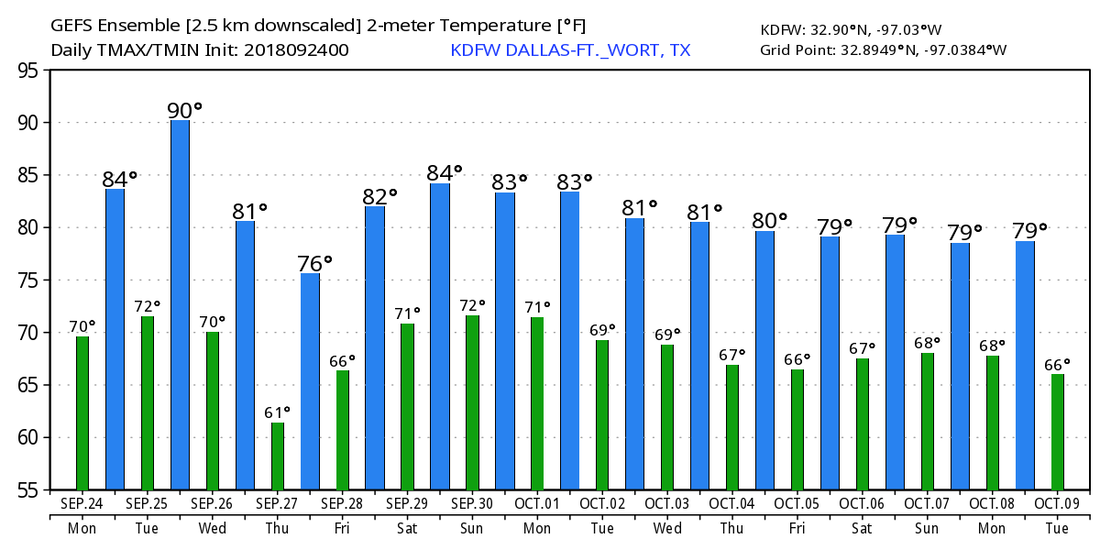 TROPICS - Tropical Depression Kirk is located in the Southern Atlantic with maximum sustained winds of 35 mph. It will continue to move west towards the Lesser Antilles as a low-end tropical storm. Subtropical Storm Leslie is further north, also hanging on as a subtropical storm. It will become post-tropical tomorrow morning with no impact to land. And, invest 98L is located near the East Coast again, and is not expected to develop due to strong upper level winds. It will ultimately curve out to sea to the north, staying away from any land masses. The rest of the Atlantic Basin is quiet. 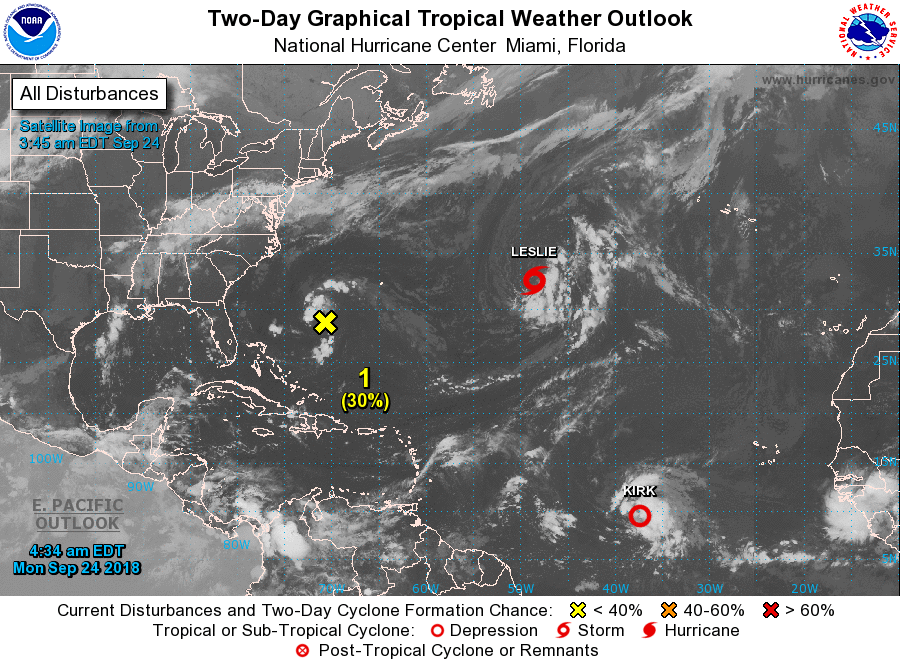 |
Archives
March 2023
Categories |
 RSS Feed
