
|
DRY MORNING - Temperatures are in the low 70s this morning... We continue to project afternoon highs in the lower 90s with a mostly sunny sky. An isolated shower or thunderstorm can't be ruled out during the afternoon hours, but the chance of one spot getting wet is only in the 10-20 percent category. REST OF THE WEEK - The weather for this week remains fairly tranquil and dry with hot and sunny conditions. Highs for Tuesday through Thursday will be in the low 90s with abundant sunshine. A surface front approaches the area on Friday, and tropical moisture begins to advect to the north at the same time. We will forecast scattered showers and thunderstorms for now with a mix of sun and clouds. The high on Friday will be in the middle 80s. The chance of one spot getting wet is only in the 30 percent category for now. THE WEEKEND - Our next best chance of rain could potentially arrive Saturday as the surface front and tropical moisture clashes. We don't expect a full-blown washout, though, as rain amounts will likely stay under the one inch range. The best chance of one spot getting wet is only in the 30-40 percent range for now, and the sky will be sunny with a few clouds. Highs for the weekend will be in the middle 80s with a decrease in rain coverage on Sunday. NEXT WEEK - We could see at least a few showers or thunderstorms during the afternoon on Monday, but it looks like the early part of next week stays dry with highs in the middle 80s. Then, beyond that point, it look like we start to get a true taste of fall weather with highs dropping to the low 80s with lows in the 60s. See the Texas Weather Discussion Video for more details. 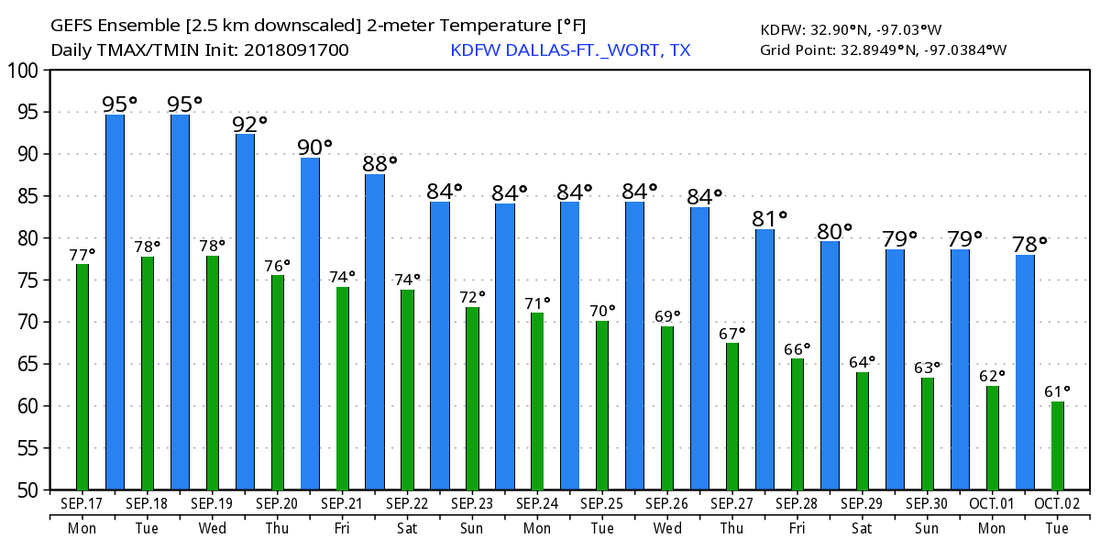 TROPICS - We only have two named storms in the Atlantic Basin currently - Florence and Joyce. Florence is finally moving to the northeast after dumping heavy rain over the Carolinas for days due to no steering currents. The only threat from this system at this point is heavy rain and small and only a couple of isolated tornadoes. It will continue to move to the northeast this week as it concludes its life cycle. Joyce is still in the Northeastern Atlantic hanging on as a Tropical Depression. It is expected to turn southward and become post-tropical by Wednesday, if it even survives for that long. No threat to any land. And, we have the ghost of Beryl out in the Caribbean Sea battling lots of dry air and shear. More than likely this will continue to not develop and move to the northwest towards the Northern Caribbean. The rest of the Atlantic Basin remains quiet. 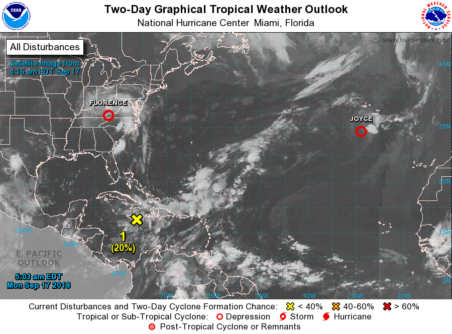 |
Archives
March 2023
Categories |
 RSS Feed
