
|
RADAR CHECK - Most of the showers this morning are located around and mainly to the west of Cleburne and to the east of Dallas. They will continue to move more to the north this morning, and more development is possible later in the day. Temperatures are only in the upper 60s this morning, and we should only warm to the upper 70s/low 80s this morning with mostly cloudy skies again. TOMORROW THROUGH FRIDAY - Scattered showers and thunderstorms will remain possible across the region through the latter half of the week, but not as scattered as last week or even today. Look for only partly sunny days with more clouds than sun Wednesday through Friday with only widely spaced showers; the chance of any one spot getting wet is only in the 20-30 percent range. Highs will be around 85° Wednesday, then closer to 90° Thursday and Friday. THE WEEKEND - Not much change. We will continue to mention the chance of a few showers during the afternoon hours with mostly cloudy skies. Afternoon highs will be in the upper 80s for both days. NEXT WEEK - Most of next week looks calm with a mix of sun and clouds each day. Highs will be in the low 90s to upper 80s to start out the week. 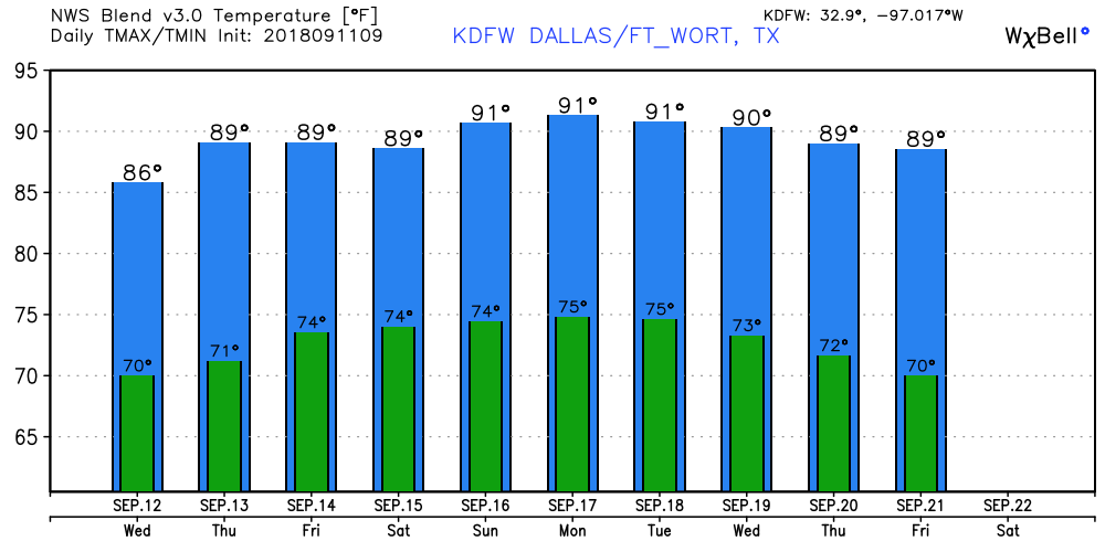 FLORENCE - Florence is now a category four hurricane with maximum sustained winds now at 140 mph. It is will moving to the northwest. Here are the latest Key Messages for Florence... • Life-threatening storm surge is expected along portions of the coast of South Carolina, North Carolina, and Virginia, and a Storm Surge Watch has been issued for portions of this area. All interest from South Carolina through the mid-Atlantic region should ensure they have their hurricane plan in place and follow any advice given by local officials. • Life-threatening freshwater flooding is likely from a prolonged and an exceptionally heavy rainfall event, which may extend inland over the Carolinas and Mid-Atlantic for hundreds of miles as Florence is expected to slow down as it approaches the coast and moves inland. • Damaging hurricane force winds are likely along portions of the coasts of South Carolina and North Carolina, and a hurricane watc has been issued for a portion of this area. Damaging wind gusts could spread well inland into portions of the Carolinas and Virginia. • Large swells affecting Bermuda and portions of the U.S. East Coast will continue this week, creating life threatening rip and sea currents. 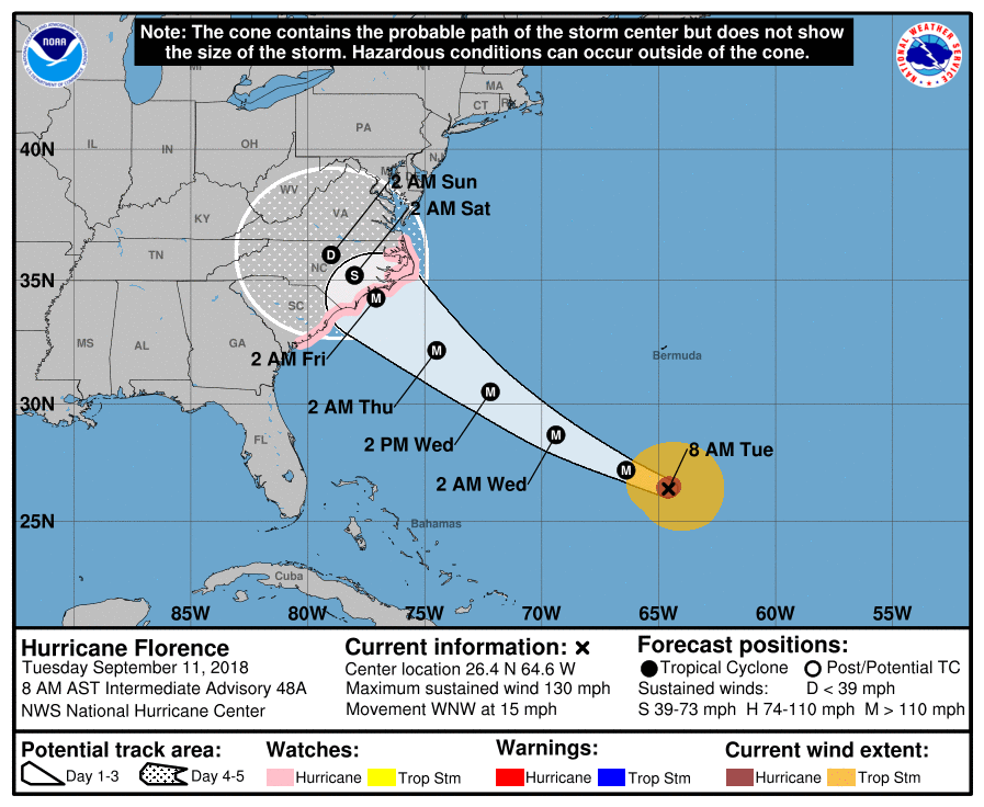 HELENE - Helene is a category two well in the south-central Atlantic. It is expected to gain latitude and turn northward, away from the U.S. 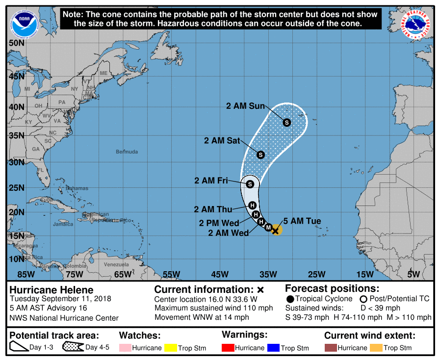 ISSAC - Isaac weakened to a tropical storm due to shear. It is expected to impact the Lesser Antilites as a tropical storm. It remains to be seen if this continues towards the bay of Campeche or turns towards the Florida Penisula. 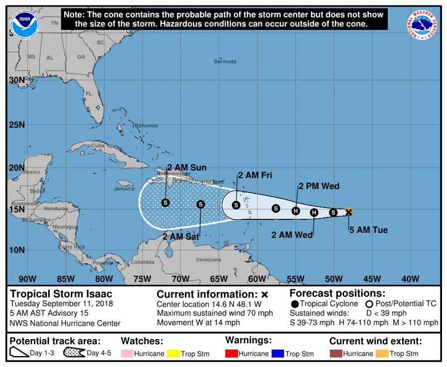 And we have invest 96L in the Gulf that has a 60% chances of becoming a tropical depression over he next five days. More than likely this impacts the Texas Coast in the form of heavy rain.
|
Archives
March 2023
Categories |
 RSS Feed
