
|
*no Texas Weather Discussion Video due to micing issue* Most of the area is dry early this morning. We will forecast a mix of sun and clouds today with afternoon highs in the low 90s. This should be our last 90° day for a while as a very strong cold front pushes through the area tomorrow morning. REST OF THE WEEK - A strong cold front pushes through North Texas tomorrow during the early morning hours, bringing prolonged cooler temperatures and more rain chances in the long-term. We will forecast at least occasional showers and thunderstorms tomorrow, though it will not be a complete washout by any means. The best chance of any one spot getting wet is in the 40 percent bracket. It won't be completely cloudy as we will have breaks from the clouds throughout the week for the areas that don't see rain. The front dissipates on Thursday, so we will stick with a dry forecast that day. Highs for the rest of the week will be in the middle to upper 70s tomorrow and Thursday due to rain and clouds, warming to the low 80s by Friday. Rain amounts between now and the weekend will mostly stay in the half-inch category with some places seeing more. Keep in mind that this will NOT be a washout, nothing like we saw this past weekend where DFW set a record for the most rain recorded in 24 hours. THE WEEKEND - Seems like we will experience a mix of sun and clouds on both days with potential for scattered showers and thunderstorms, mainly during the afternoon hours. The chance of one spot getting wet is in the 20/30 percent range, and highs will remain in the mid 80s. NEXT WEEK - Not much change. We are keeping a close eye on the mid-latitude westerlies in the north that could finally beat down the ridge in the south and Central U.S. once and for all towards the end of next week. 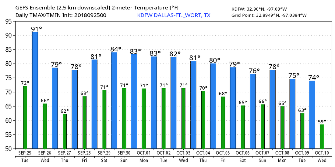 TROPICS - What used to be Tropical Depression Kirk is just an open wave in the Atlantic, there is some chance that it tries to redevelop over the coming days as it gets closer to the Lesser Antilles. Subtropical Depression Leslie will become post-tropical by tomorrow. The remnants of Florence is still hanging around near the U.S. East Coast; if it wants to try to redevelop again, it should remain offshore. There are no tropical cyclone threatening the Gulf of Mexico or the U.S. at this time.
|
Archives
March 2023
Categories |
 RSS Feed
