
|
Today most locations start the day off with highs in the low to mid 70s for the morning commute, staying dry until the cold front comes through. Needless to say, most of this post will be about Hurri When the cold front comes through, we will notice a temperature difference (which won't come until tomorrow) and will mention a chance for afternoon/evening showers and storms. Though most locations will ultimately end up staying dry, the chances of one spot getting wet is in the 20-40 percent bracket. The Rest of the Week - We should ultimately trend cooler in drier air, which is a great feel for early September. Highs will be in the mid to low 80s with lows reaching down into the 50s in some spots. With plenty of sunshine, we should continue to be in drier air for the latter half of the week. Friday and the Weekend - We will continue to feature dry weather with mostly sunny and pleasant days along with cool nights. Highs will continue to stick towards the mid 80s with lows in the 60s. Great weather for high school football games. Next Week - Not much change. We will continue to have sunny, pleasant days with highs in the mid to upper 80s, which is a good thing for early September. 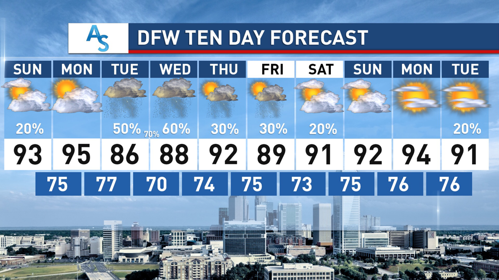 DANGEORUS HURRICANE IRM - Irma is continuing to head towards the Leeward Islands. As I am writing this, Irma strengthens to a dangerous CATEGORY FIVE HURRICANE WITH MAXIMUM SUSTAINED WINDS OF 175 MPH. The central pressure is down to 929 mb (millibars). A Hurricane Warning is in effect for… * Antigua, Barbuda, Anguilla, Montserrat, St. Kitts, and Nevis * Saba, St. Eustatius, and Sint Maarten * Saint Martin and Saint Barthelemy * British Virgin Islands * U.S. Virgin Islands * Puerto Rico, Vieques, and Culebra 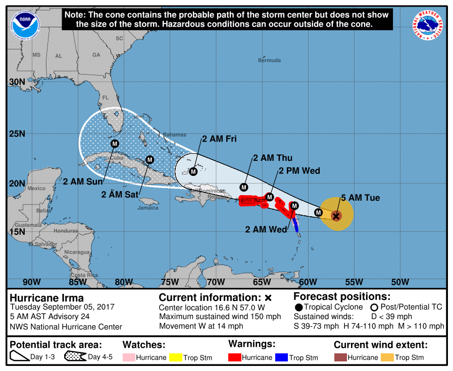 Here are some important things to mention as we ride through this...
*Do not focus on the exact forecast forecast track, especially at the longer ranges, since the average NHC track errors are about 175 and 225 statute miles at days 4 and 5, respectively. *Irma is expected to make a hard right turn over the weekend in response to a deep upper trough over the eastern half of the U.S. Exactly when that turn happens will determine the ultimate impact on the Florida Peninsula. * Unfortunately, both primary global models (the American GFS and the European ECMWF) show the core of Irma moving northward, through the spine of the Florida Peninsula, in the Sunday/Monday time frame. This, of course, could change, but there is excellent model agreement in this idea. *People in the Florida Peninsula need to continue preparations for a major hurricane, and listen carefully to statements from local governments later this week as some evacuation orders will most likely be needed. Tropical storm force winds could reach South Florida as early as Friday night. *It is unlikely that Irma enters the Gulf of Mexico. For now, we expect little, if any impact on places like Gulf Shores, Pensacola, Navarre Beach, and Destin. Panama City Beach could see some wind and rain Sunday or Monday, but they will be on the “good”, drier side of the hurricane most likely. *Always use fresh, updated weather information. With any tropical system forecast changes are very possible, if not likely, as it goes closer to land and the prime U.S. upper air network. Thankfully both USAF and NOAA aircraft are collecting data this morning; this goes into the computer models we use to make them more reliable. The Rest of the Tropics - There is a wave in the western Gulf of Mexico that may show some slow development signs, but should not affect the US due to the cold front that will move south. There is another wave trailing Irma that may become Tropical Storm Jose in the next 3 to 5 days. See the Texas Weather Discussion Video for more details. |
Archives
March 2023
Categories |
 RSS Feed
