
|
Summer-Like Weather Continues - An upper-level ridge will continue to stay on top of North Texas, meaning summer-like weather will prevail. We continue to forecast highs in the 90-95 degree range with a mostly sunny sky with a few clouds throughout the day. Rain chances will continue to remain very low today, the better chances will go towards West Texas. If we do see anything on the radar today, it will be in the form of widely scattered, random showers that will quickly dissipate. This will be the case for most of the week. Little to no rainfall in North Texas is expected as a result of the warm air associated with the upper ridge. The summer pattern continues - mostly sunny days with fair nights, with high temperatures holding in the 90-95 degree range. The chances of showers will continue to be to the west and southeast of DFW. The Weekend - Not much change. Highs will continue to hold in the low 90s with only a slim chance of an isolated shower or storm. Next Week - Though the ridge continues to hold, we mention a slight chance of showers and storms early next week, mainly during the afternoon/evening hours. The best chance of one spot getting wet is in the 10-20 percent category, but no signs of any widespread rain any time soon. Highs should drop to the mid to low 80s as the ridge weekends and fall magic comes into play. 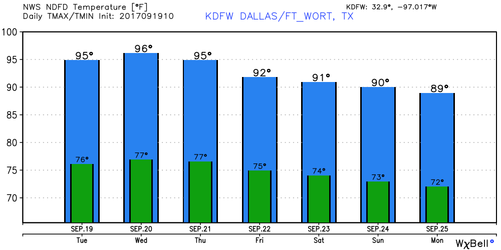 Tropical Weather - Lee is now just a remnant circulation in the Atlantic Basin, which brings us down to two active storms... Jose - Jose is still hanging on as a minimal hurricane with maximum sustained winds of 75 mph. It should weaken to a tropical storm tonight. The center circulation will remain offshore, but is enough to warrant a tropical storm warning for Cape Cod. It will attempt loop well to the east of New England, before becoming post-tropical cyclone by this weekend. 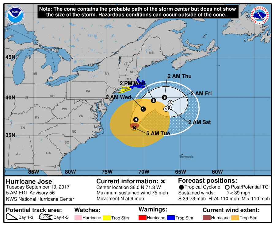 Maria - Maria is an extremely dangerous and life-threatening category five hurricane on the Saffir-Simpson Scale. The eye went over the Dominica Islands last night as a category five. It has maximum sustained winds of 160 mph. This storm may fluctuate in intensities, but is still forecast to remain an extremely dangerous category four or five storm as it makes its way towards Puerto Rico. 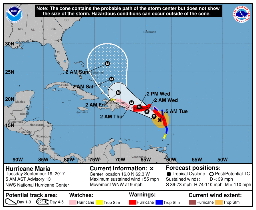 A Hurricane Warning is in effect for...
* Guadeloupe * Dominica * St. Kitts, Nevis, and Montserrat * U.S. Virgin Islands * British Virgin Islands * Puerto Rico, Culebra, and Vieques A Tropical Storm Warning is in effect for... * Antigua and Barbuda * Saba and St. Eustatius * St. Maarten * Anguilla * St. Lucia * Martinique A Hurricane Watch is in effect for... * Saba and St. Eustatius * St. Maarten * St. Martin and St. Barthelemy * Anguilla * Isla Saona to Puerto Plata A Tropical Storm Watch is in effect for... * St. Vincent and the Grenadines * West of Puerto Plata to the northern Dominican Republic-Haiti border This storm will continue to gain latitude as it moves to the northeast. Confidence is increasing that this storm will not impact the Gulf of Mexico or Florida. See the Texas Weather Discussion Video for more details. |
Archives
March 2023
Categories |
 RSS Feed
