
|
Sweater Weather? - Down here in the south, we are enjoying the coolest morning in 6 or 7 months. At 5 AM, DFW Airport recorded a temperature of 66 while Arlington had a recorded temperature of 53! This is 10 to 14 degrees below average for lows. Today will feature abundant sunshine in full force with highs in the low to mid 80s with no rain at all. We are expected to stay this beautiful during the weekend as well - lots of sunshine with cool nights and highs in the low to middle 80s for the weekend. Football Friday - Tomorrow will be a perfect day for high school football games during the late evening/night hours. With the sun just starting to go down at around kickoff times, the sky should be clear with temperatures ranging from 82-85, dropping to the mid to upper 70s by the end of the game. Tomorrow, Mansfield Summit High School takes on Chisolm Trail at an away game tomorrow evening (kickoff at 7:30p). The sky will be clear and beautiful with the temperatures nearing the 70s, dropping to the mid and upper 70s near the final whistle. Next Week - Texas continues to stay in a dry airmass, which will create plenty of sunshine with highs in the upper 80s to low 90s. We could start to warm up a tad by the latter half of the week. Threopics - There are currently three active hurricanes in the Atlantic right now; Katia in the Southwest Gulf of Mexico near the Bay of Campeche, Irma to the north of the Dominican Republic, and Jose out in the open Atlantic. This is the first time we have had three active hurricanes in the Atlantic Basin since 2010. 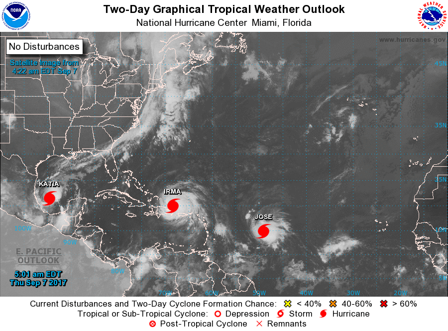 Katia is a minimal category one hurricane that will move into Mexico later this week, posing no threat to Texas or the Gulf. Jose will continue to stay over open water for the next week... We currently do not know if this will just churn in open water for all of its life cycle, or if it will turn to the U.S. Way too early in the game to predict. IRMA IS STILL A DANGEROUS CATEGORY FIVE - Irma still has maximum sustained winds of 180 mph. With Irma still a category five storm, some hiccups in the intensities is possible as it reaches more land, but is still expected to remain a dangerous category four/five hurricane for the next several days. Irma is moving to the northwest at 15 mph, and is expected to end up near the central Bahamas on Friday. A Hurricane Watch will likely be issued for the southern Florida coast and Florida Keys. 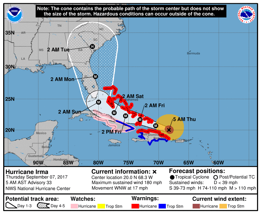 This storm is expected to make a sharp right turn near Cuba, and will end up near Miami, Florida by Sunday morning. From there, this will skirt or be just off of the Florida Atlantic Coast, making second landfall near Savannah, Georgia by Monday evening.
Here are some things to think about... *Don’t focus on the exact track since the average NHC track errors at days 3, 4, and 5 are about 120, 175, and 225 miles, respectively. *Those on the Florida Atlantic coast (Miami, Fort Lauderdale, West Palm Beach, Daytona Beach, Jacksonville) need to continue preparations for a major hurricane, and heed evacuation orders from local officials. *For the west coast of Florida (places like Naples, Fort Myers, Sarasota, St. Petersburg, and Tampa, lots of wind and rain are likely Sunday, but the most severe impact from Irma should be to the east. *Concerning Orlando and Disney World, Sunday will be very wet and windy, but for now it looks like the highest impact will be a little east of there. The weather will improve greatly Monday. *Those on the Georgia and South Carolina coasts need to prepare now for hurricane conditions expected Monday or Monday night of next week. For now, the NHC forecast has Irma as a category two at the time of landfall in this region, but remember the skill set in forecasting hurricane intensity is not especially high at 120 hours. |
Archives
March 2023
Categories |
 RSS Feed
