
|
Sweater Weather? - At 5:21 AM, DFW recorded a temperature of 67 degrees. Generally, mostly all of North Texas is in the low to mid 60s this morning, which the naturally colder pockets reaching down towards the low 50s, maybe even into the 40s. This is the coldest North Texas has been in three months, which is a great sign that fall-like weather is on the way. Rain is not expected for North Texas for the next week or two. So we will continue to stick with abundant sunshine with clouds out at times with highs in the low to mid 80s through the weekend. The morning lows will continue to peak near the mid 60s, with some of the naturally cooler spots reaching towards the mid 50s. The weather will continue to stay very pleasant for high school football games on Friday and the weekend. This week, Summit High School will take on Chisolm Trail on Friday (kickoff at 7:30p). The sky will continue to be clear with highs dropping to the upper 70s after sunset. Next Week - Not much change. Hurricane Irma and Tropical Storm Katia will stay to the east and south of us to affect anything in North Texas. We stick with pleasant conditions with abundant sunshine along with mid 80s for the high temperature. 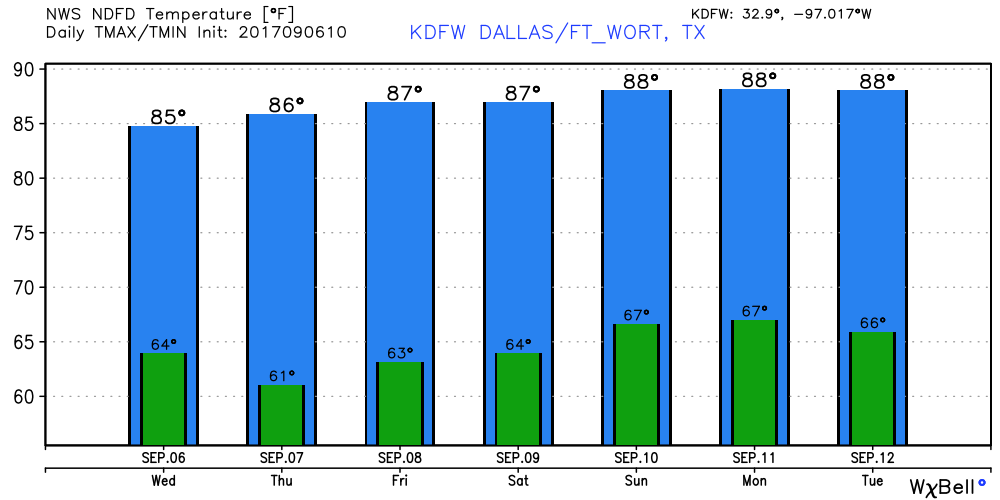 IRMA IS STILL A DANGEROUS CATEGORY FIVE HURRICANE - Irma continues to have maximum sustained winds of 185 mph, which is tied to the second strongest hurricane on record in the Atlantic basin. Hurricane Allen (1980) continues to be number one with maximum sustained winds of 190 mph. 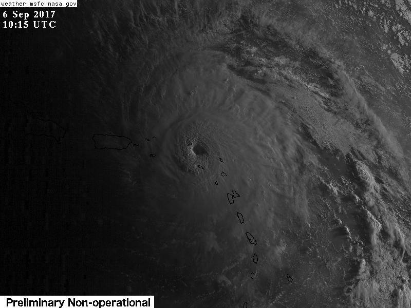 This hurricane is expected to take a sharp right turn to the right when approaching northern Cuba in response to an upper trough in the Northeast US. Models continue to show the storm moving more to the east, and the NHC respectively adjusts their forecast as well. 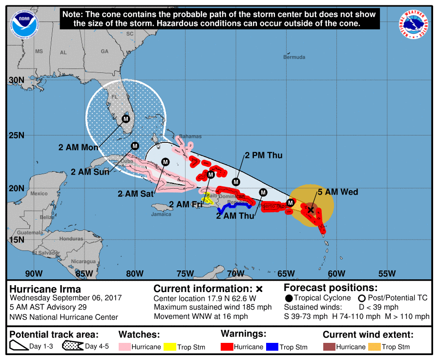 As models suggest, Irma is likely peaking in intensity at this time. Irma maybe on a weakening trend by the time it nears Florida due to land interaction. This will still remain a dangerous and potentially life-threatening major hurricane. Some notes while we le we get through this... *Don’t focus on the exact forecast track, especially at the longer ranges, since the average NHC track errors are about 175 and 225 statute miles at days 4 and 5, respectively. *There is a chance that Irma will follow a path similar to Matthew last year, with the center staying just offshore (east of the Florida Atlantic coast). But, there is also a chance the center comes right up the spine of the peninsula. One way or another everyone in the Florida Peninsula needs to continue preparing for a major hurricane. *Both major global models (ECMWF and GFS) now suggest a landfall somewhere on the coast of South Carolina Monday or Monday night. While the most severe impact will be along and north of the point where this landfall happens, people from Jacksonville to Savannah to Charleston to Cape Fear need to be ready to prepare for hurricane conditions as a course of least regret. *It is still a little too early to give specific impacts (wind speed, rain amounts, storm surge, etc) for any given point along the potential path of Irma across the Florida Peninsula, or the coasts of Georgia or the Carolinas. *Be sure you are using current information if you are in the areas potentially impacted by Irma. If you are working with a forecast more than six hours old, that is bad information. And, be sure and heed any advice given by local officials. Tropical Storm Jose - This is the system in the Atlantic that is trailing Irma that is expected to become a hurricane during the next 24 hours. It should stay well to the north of the Leeward islands. Afterwards, due to weak steering currents, it will most likely hang in open water for the next several days. Does not look like an impact to land, but will continue to monitor... 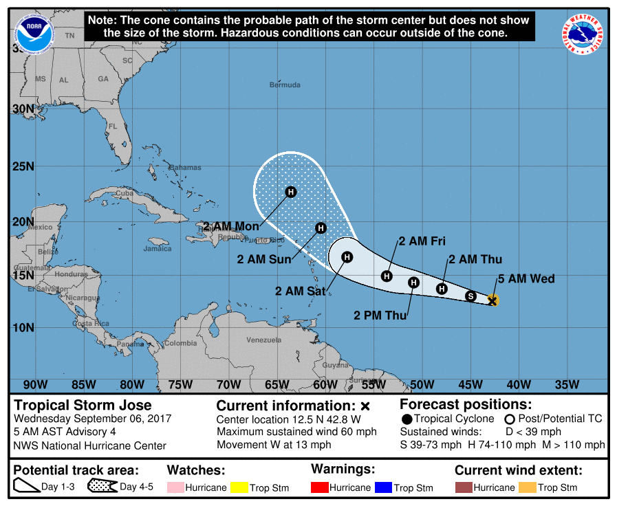 Tropical Storm Katia - This has formed in the Bay of Campeche in the Gulf. This storm will drift into Mexico during the next 3-5 days with no impacts on Texas or the US. See the Texas Weather Discussion Video for more details. 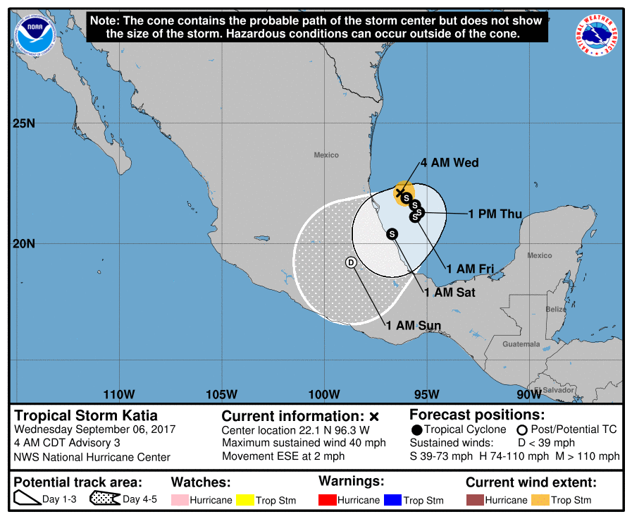 |
Archives
March 2023
Categories |
 RSS Feed
