
|
Sunny, Pleasant Mornings, Cool Nights - Although a tad warmer than yesterday, most locations in north Texas start the day in the 50s, with DFW in the 66 degree range. There is no reason to derail from the same forecast since last week - Pleasant days with abundant sunshine, and calm and cool nights. Today and tomorrow's high will be in the 85-87 degree range, warming up to the upper 80s/low 90s by early next week. A perfect evening/night is in store for us for those who are traveling to see high school football; clear skies with temperatures falling into the mid 70s. Summit High School will be taking on Chisolm Trail at an away game Friday evening (kickoff @ 7:30p). As the sun is setting, the sky will be clear with temperatures starting at 82 at kickoff, dropping to near 75 at the end of the game. Thropics - There are currently three active hurricanes in the Atlantic - Katia, Irma, and Jose. Katia is located in Gulf, and is expected to make landfall on Mexico's coast tonight. No impacts on Texas or the U.S. The second hurricane is trailing Irma. Moving to the northwest, this still remains a major (category) hurricane with maximum sustained winds of 125 mph. This is expected to skirt the northern Leeward Islands before going back into open water and sitting for a few days as steering currents collapse. It remains unknown If Jose will be washed away or if it will try to turn west. The GFS ensemble members have this turn northeast. Dangerous Situation Unfolding for Irma - When it comes to Irma, nobody should be throwing the words "downgraded" as this is still a dangerous category four hurricane with maximum sustained winds of 150 mph. 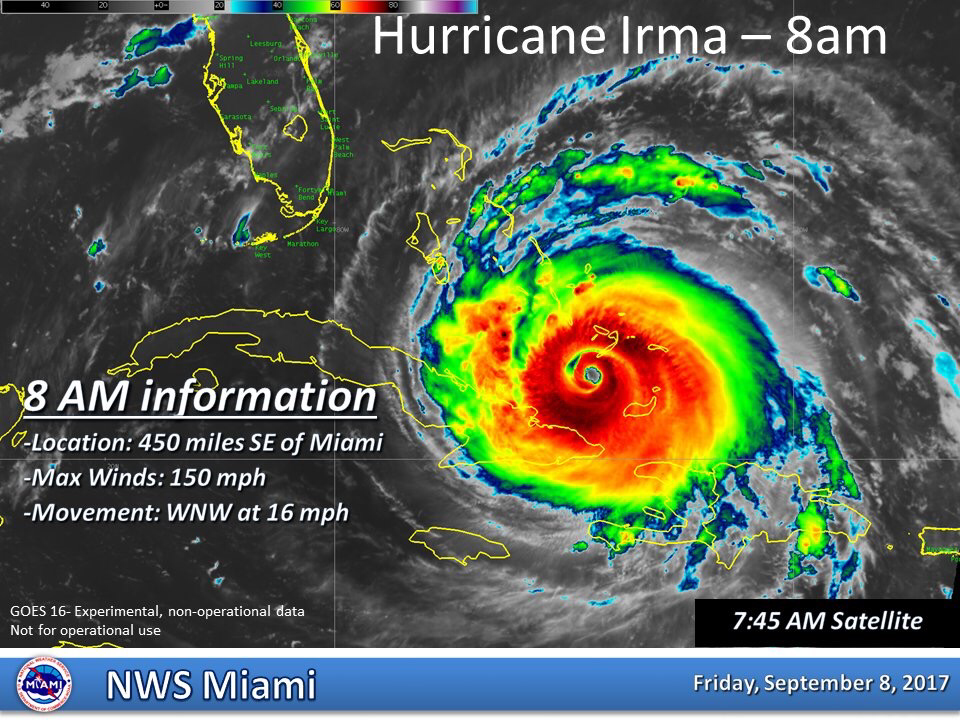 This storm should move away from the Turks and the Caicos this morning and should begin entering the southern Bahamas. The hurricane will move between the Bahamas and Cuba during the next two days, then making a hard right turn towards the Florida Keys and the Penisula. 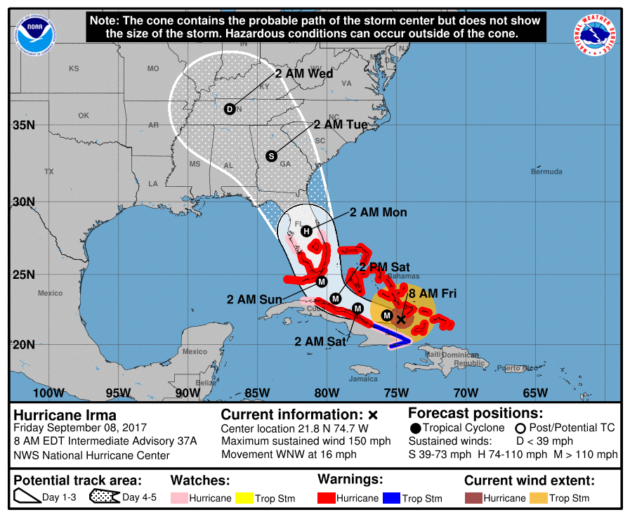 Sadly, the NHC track has this hitting south Florida directly.
Here are the notes: FLORIDA EAST COAST: The most severe storm surge and wind damage will be along Florida’s East Coast… from Miami up to Jacksonville. Structural damage is likely along with storm surge flooding. Widespread power outages are expected as well. Evacuation orders have been issued for much of the coast, people need to heed those orders. ORLANDO: Hurricane force winds are likely in Orlando Sunday and Sunday night. This could bring some structural damage and widespread power outages. The weather improves Monday, but keep in mind there could be infrastructure damage from the storm. If you have a trip planned to Disney World next week, keep an eye on their Twitter feedor FB page. FLORIDA WEST COAST: Cities like St Petersburg, Tampa, Sarasota, Fort Myers, and Naples will have lots of wind and rain Sunday. There is potential for scattered structural damage and widespread power outages. But, the most severe damage will be over on the Atlantic coast. FLORIDA PANHANDLE/ALABAMA COAST: While it will be windy Sunday night and Monday (a north, offshore wind), places like Gulf Shores, Pensacola, Navarre Beach, and Destin should be dry. Winds will be higher at Panama City Beach Monday, in the 25-35 mph range, with some rain possible, but the main impact of Irma will remain to the east. Winds will diminish Tuesday and the weather looks great for the rest of the week. If I had a vacation trip planned to Panama City Beach, I would go without hesitation. GEORGIA/SOUTH CAROLINA: Atlanta could see winds in the 30-40 mph range late Monday night and Tuesday as the circulation center passes pretty much over the city; there could be some trees blown down and scattered power outages, but noting widespread is expected. A few isolated tornadoes are possible Tuesday over East Georgia and South Carolina.Lots of wind and rain for the Georgia and lower South Carolina coast Monday, but Irma will not make a landfall on the the coast there based on the latest NHC forecast. REMEMBER: There is a flood of weather information floating around social media… some good, some bad. Stick with a reliable source, or the official products from NHC. And, if you are using a forecast that is more than six hours old, it is bad information. Use the most current update. |
Archives
March 2023
Categories |
 RSS Feed
