
|
MILD MORNING - We start the morning with temperatures in the mid to upper 50s across the North Texas region, which is actually around our average high temperature of 57° for January 22. Today will be mostly cloudy and windy in advance of another cold front, and a few showers will become possible beginning in the afternoon. The air will be very stable, so there is no threat of severe storms, and probably no thunder. Rain amounts will stay under a quarter of an inch with heavier totals to the east. Today will be mild with highs in the mid 60s. Colder air begins to flow into the region overnight, and there is a chance that a few slow flurries could develop early Wednesday morning, but for now we expect no accumulations or impact. Tomorrow will feature a mostly sunny sky with highs in the upper 40s with a 15-20 mph northwest wind. Then, we warm ten degrees by Thursday with another mostly sunny sky. We will continue to see winds of 10-20 mph, but we will see winds shifting to the north by the afternoon. Then Friday will be partly to mostly sunny with highs in the upper 40s with a north wind of 15 mph. THE WEEKEND - Not much change for the weekend. Saturday will be mostly cloudy with highs in the upper 40s to low 50s. I wouldn't be surprised if we see a few showers squeeze out of the clouds. We fully transition to sunshine by Sunday with highs in the low 50s. NEXT WEEK - Monday will be dry and sunny, then clouds start to roll in for Tuesday and Wednesday, before transitioning back to sun for the last day of January. It looks like we won't get out of the 40s with the clouds in place Tuesday and Wednesday. We mention that there is no evidence of any significant snow or ice event for North Texas over the next 10 days, although a few flurries are possible very early tomorrow morning. See the Texas Weather Discussion for more details. 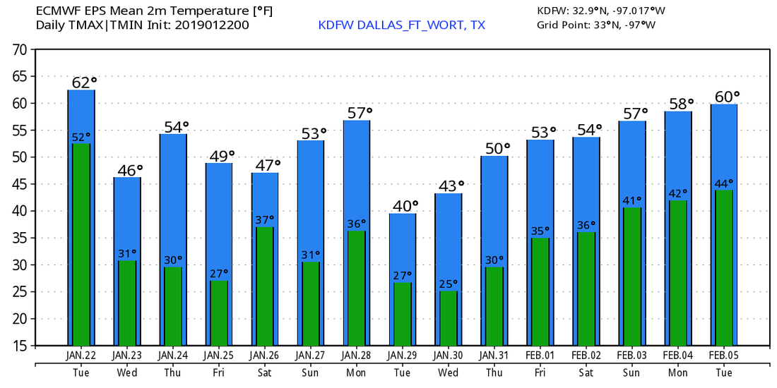 |
Archives
March 2023
Categories |
 RSS Feed
