
|
ANOTHER COOL MORNING: In advance of a storm system, temperatures are currently in the mid 60s this early morning, which is actually not bad for mid April. We actually hang on to clouds this morning, but we will eventually see some clearing as we head into the early afternoon hours. This is typically the case for a severe weather day here in Texas. TAKE A DEEP BREATH: Before I say anything else, keep in mind that we are basically in the peak of severe weather season, meaning, severe weather threats like this will be maximized around this time of the year. There is no need to be scared, however, you need to make sure you are prepared for this evening by making sure you have a way of receiving warnings, and to make sure you and your family or loved ones have a safe place in your home so you can quickly jump in in the event of a significant hailstorm or tornado warning. Not everyone will see severe weather today, and there is definitely a chance that we will see absolutely nothing at all. However, everyone should be prepared today. SEVERE WEATHER EVENT THIS EVENING THROUGH THURSDAY MORNING: A potent storm system located over West Texas will bring the potential for severe thunderstorms over much of North and Central Texas this afternoon through the overnight hours. We have found out over the years that North Texas is a famous hail corridor, and we tend to get more reports of hail and damage from hail than anywhere else in the country. We will be dealing with that threat today. We typically have these great threats of significant hail only once, maybe twice a year at best, so this is something that should not be taken lightly. Forecast surface based CAPE values (instability) are expected to soar into the 3,000/4,000 j/kg range, creating a "powder keg" situation by the late afternoon hours. The Storm Prediction Center maintains the "enhanced risk" (3/5) of severe storms over all of the North-Central Texas region through Central Texas and some of the adjacent states. 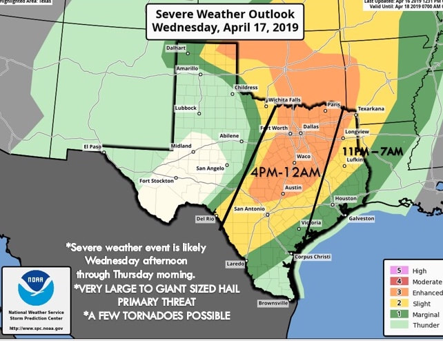 Do not get caught up in looking at these risk maps and lines, colors, and vocabulary. This is just simply a guideline, meaning, like we saw on Saturday, storms do not read these maps and certainly do not know where the lines are located. Just know that all of North and Central Texas has a risk of severe weather this afternoon into the overnight hours. TIMING/THREATS: There is the potential for multiple wavves of storms from around 4:00 PM through 12:00 AM Thursday morning. The primary threat with the initial batch of supercells will come from very large to giant sized hail. These usually peak in the size of baseballs, softballs, and grapefruit in the most extreme cases. We could be dealing with that today. Also, the tornado potential is low, but not zero. We will have to especially watch this as the sun goes down as mid level winds become stronger after dark. The damaging wind risk will increase as storms congeal into a line over time. RAIN: Amounts of around 1- 1 1/2 inch are likely. Some flooding issues are possible with cities that receive multiple severe storms. CALL TO ACTION: Be sure you have a way of getting severe weather warnings; a NOAA weather radio is the base standard, and having a good smart phone app is the next level. Make sure you can identify the safe place in your home, and everyone knows where it is. In that safe place, have hard sole shoes and a portable airhorn in case you need help. COLDER AIR: Thursday will be breezy and much cooler with clearing taking place; some lingering showers is possible during the morning hours. Temperatures will hold in the cool 70s much of the day. Then, we drop into the even cooler low 50s by daybreak on Friday. Friday afternoon will be in the low to mid 70s. THE WEEKEND: Expect a much calmer weekend with mostly sunny skies and windy conditions in place. Each day will feature brisk winds, mostly sunny skies with highs in the low 80s. NEXT WEEK: Medium range model data suggests we might see some rain during early next week, but for now, it doesn't look like a setup for severe thunderstorms. See the Texas Weather Discussion Video for more details. 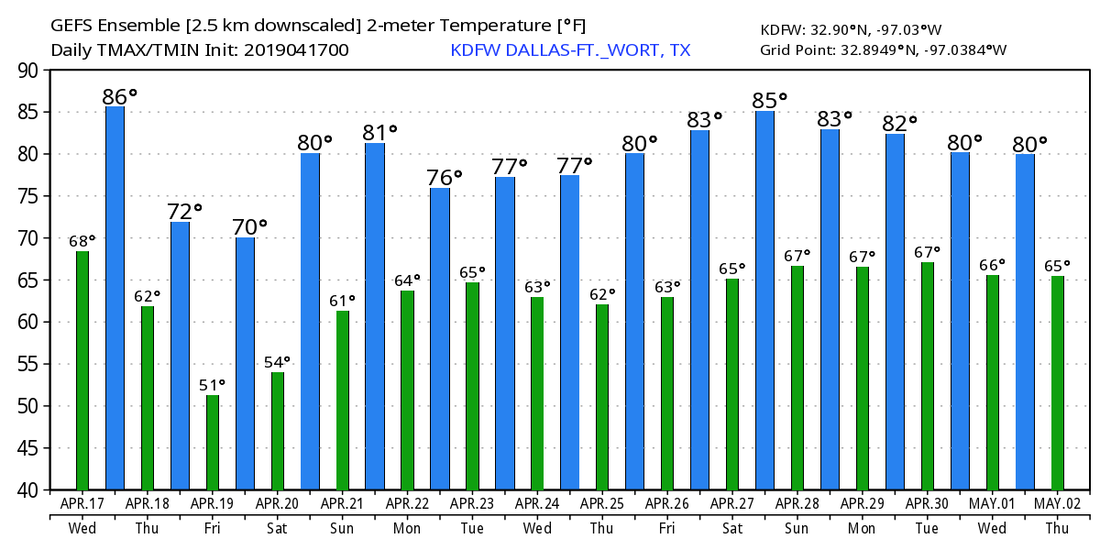 |
Archives
March 2023
Categories |
 RSS Feed
