
|
COMFORTABLE MORNING: After a long, dreary weekend of an unsettled weather pattern, the surface low is finally more in the Ark-La-Tex region, and temperatures are currently in the upper 50s to low 60s this morning. With a full supply of sunshine, we should experience mostly sunny skies with a high in the low 80s this afternoon. Expect even sunnier conditions on Tuesday with sunshine in full force. Most of us will start to feel pretty warm with highs approaching the mid to upper 80s by the afternoon. MID-WEEK: We warm up even more with an abundance of sunshine, and we could see our first 90° day of the year this Wednesday. With a tight pressure gradient with a surface low positioned in Colorado, we will experience gusty winds with a southerly wind of 15-30 mph with gusts of up to 45 mph. Keep in mind that the average high for April 10th is 75° in DFW. We will be well above that... A cold front moves through Thursday morning, and we will only reach the low 70s as a result. Winds will shift to the northwest, but we will still stay breezy. And, Friday should still be mostly dry and relatively breezy with highs in the mid to upper 60s. Both days will feature a mostly sunny sky. THE WEEKEND: Another influx of moisture from the Gulf moves through most of Texas, and we should see another round of scattered showers and thunderstorms on Saturday. It is unknown if we see more severe weather, but for now, this looks to be more of a rain event for North and Central Texas. Then, we begin to clear during the afternoon on Sunday with some sun at times. Highs will be in the low 60s on Saturday, followed by middle 60s by Sunday. NEXT WEEK: Monday stays fairly dry, but another surface front could bring storms through parts of North Texas on Tuesday. At this point, it is way too early to forecast any potential for severe weather. Most of next week stays in the 70s with mostly sunny skies. See the Texas Weather Discussion Video for more details. 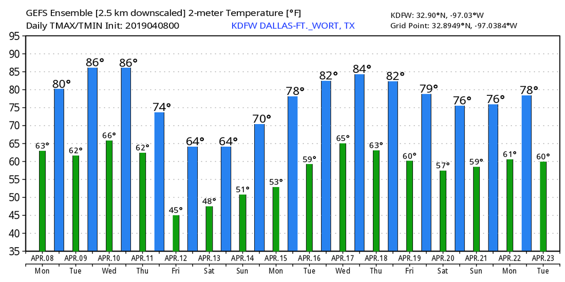 |
Archives
March 2023
Categories |
 RSS Feed
