
|
CLASSIC JUNE MORNING - The day is new, but the forecast feels old this morning with temperatures in the mid to upper 80s. This afternoon will be no different with afternoon highs in the mid to upper 90s with a mix of sun and clouds. However, we are monitoring a complex of showers and thunderstorms in Central Oklahoma that are progressing to the south. The main concern is that if this verifies, we will see some of those thunderstorms move into the North Texas area. Some could be on the strong side with a chance of mainly damaging winds and a hail risk. We do note that the SPC has a marginal risk of severe thunderstorms for much of the DFW metroplex. 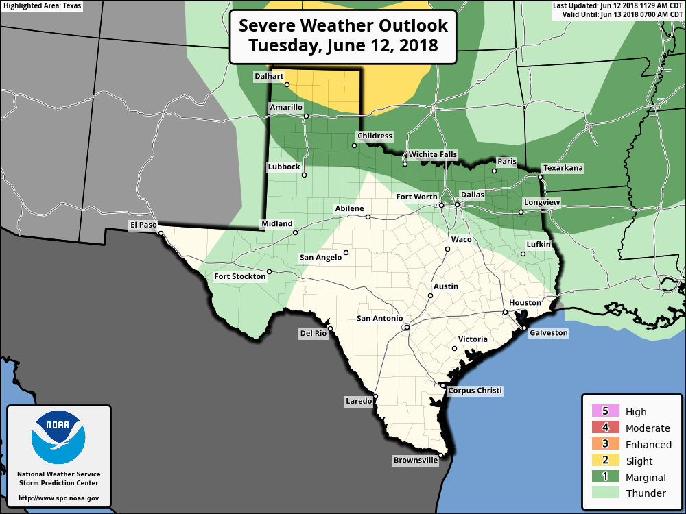 Just know that not everyone will see rain, and the best chance of any one spot getting wet will be in the 50 to 60 percentile. After today, the forecast for the rest of the week will not chance that much. More sun than clouds with afternoon highs in the mid to upper 90s with morning lows in the mid 70s. THE WEEKEND - Most of the weekend stays dry for the most part. By Sunday evening, moisture will continue to advect from the Gulf, which will spread into much of Texas through the early part of next week. But most of the weekend stays dry with highs in the low to mid 90s. NEXT WEEK - The early part of next week will feature scattered to numerous showers and thunderstorms with tropical moisture moving to the north. Right now, the main concern is heavy rain at times, and the best chance of any one spot getting wet will be in the 50/50 percent range for now. Isolated thunderstorm chances will continue to the latter half of the week. Highs will be in the low 90s due to rain-cooled air. See the Texas Weather Discussion Video for more details. 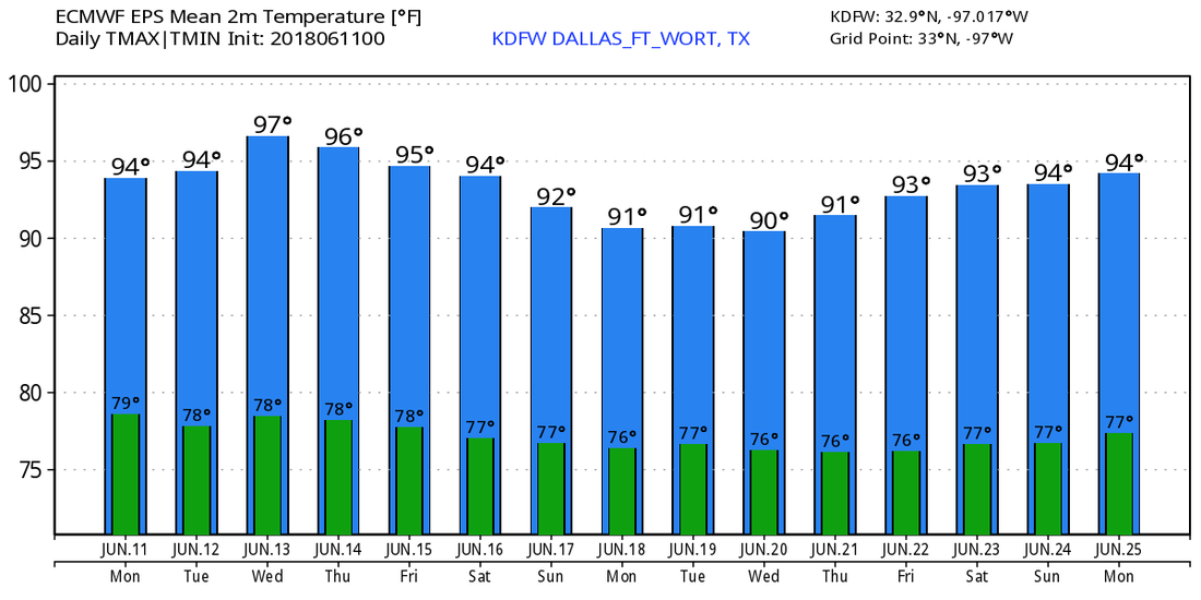 TROPICS - A broad area of disorganized showers and thunderstorms is located in the western Caribbean Sea. It will continue to progress northwestward towards the Lone Star State. NHC only gives this a 20 percent chance of developing within the next five days. However, this will most likely only bring moisture and beneficial rains to our state without becoming a tropical cyclone. 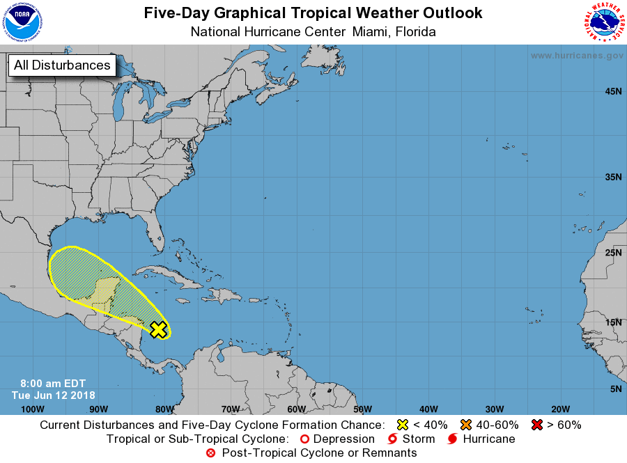 Going to the eastern Pacific, Hurricane Bud is now a category three storm with maximum sustained winds of 125 mph. It will start to weaken later today as it progresses towards Baja California within the next two to three days. By that time, the main threat will be heavy rain. Some of the moisture associated with the remnants of Bud could work its way towards southwest US during the weekend and the early parts of next week. 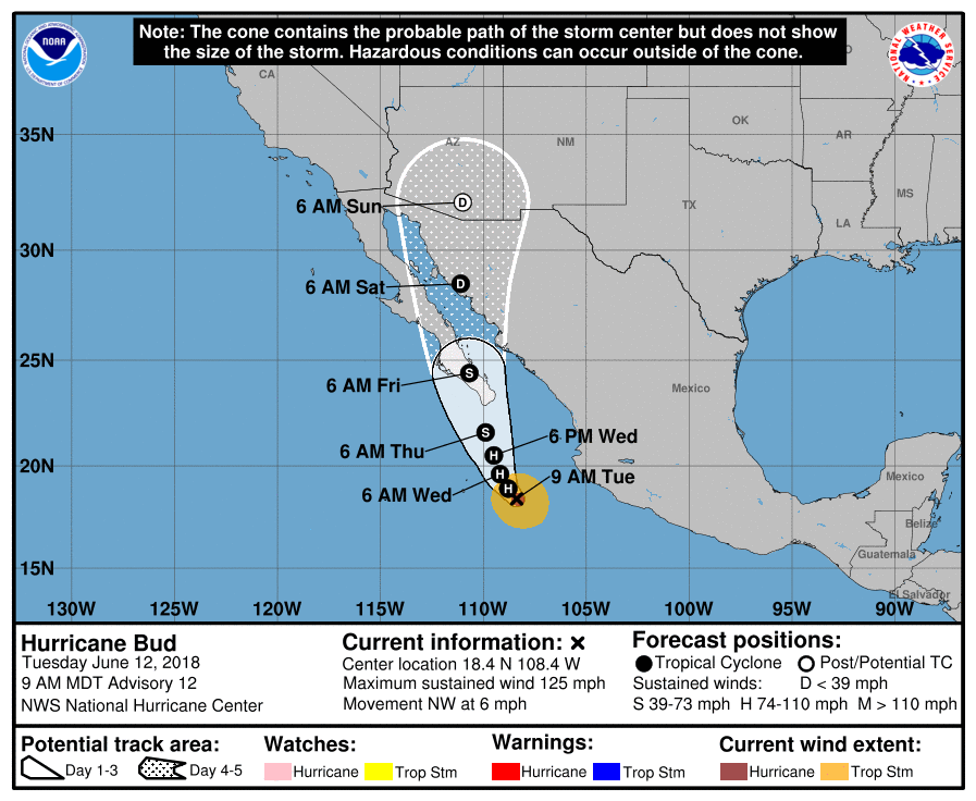 |
Archives
March 2023
Categories |
 RSS Feed
