
|
ANOTHER VERY WARM AFTERNOON - Temperatures are in the upper 80s to low 90s just before 1PM. Expect more sunshine with an increase in the temperature by about a few degrees during the late afternoon hours. This is the time of the year when we forecast the chance of a random, pop-up isolated thunderstorm for the region. We will not be in a volatile airmass like yesterday, so a localized severe weather event is not anticipated, but any storm could produce a heavy downpour, frequent lightning, gusty winds, and a hail threat. TOMORROW AND FRIDAY - Not much change. Dry air stays in place through the region with sunny days and fair nights. Highs will remain in the middle to upper 90s with the heat index in the 100 degree range. THE WEEKEND - Dry air continues to stay in place for the region, which will lead us to a dry forecast through the weekend with more sun than clouds. Again, any isolated storm that forms will have the potential to turn strong to severe. The best chance of one spot getting wet is in the ten to twenty percent bracket. Highs will continue to be in the middle to upper 90s. NEXT WEEK - Our typical June pattern will continue to stay the same through next week. Mostly sunny skies, fair nights. Any thunderstorm that forms will be random and will pose a threat for lightning, downpours, gusty winds, and hail. Highs will remain in the mid to upper 90s for much of the week. See the Texas Weather Discussion Video for more details. 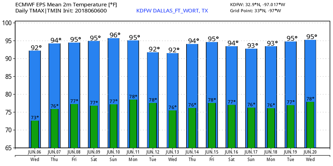 TROPICS - The Atlantic Basin will continue to remain quiet for the next week, and tropical cyclone formation is not anticipated. However, if you go to the Central Pacific, we have Tropical Storm Aletta, the first tropical storm of the season. It is forecast to become a hurricane tomorrow evening, but will move out to see and stay far away from land.
|
Archives
March 2023
Categories |
 RSS Feed
