
|
TODAY - Temperatures are currently in the upper 70s this morning as you wake up. Today will be no different from the past several days; hot afternoons, fair nights with highs in the upper 90s. Places to the west will likely reach the triple digits. A Heat Advisory is still in effect for Young, Jack, Stephens, and Palo Pinto counties until 7PM tomorrow. THE WEEKEND - A good portion of Saturday will be dry. We will likely see our new record temperature of 102-104, beating out the previous record of 100 degree set in 1998. Heat index values will likely be in the 105-110 range, so make sure you are exercising heat safety. A cold front approaches from the north Saturday evening, and a band of isolated showers and storms will be possible along the front. Some of the heavier storms could produce downburst winds along with a low-end hail threat. Most of the storms will start to develop at around 6:30PM, so if you have any outdoor events planned for the evening, just be aware and keep an eye on the radar and pay attention to severe thunderstorm warnings if they are required. Since these storms are more isolated in nature, the chance of one spot getting wet is around the 50/50 range. Cooler air will follow behind the front, and highs will stay in the mid 90s on Sunday with more sun than clouds. NEXT WEEK - Most of the week will stay dry, though a warm front will lift northward which could carry an isolated shower or storm or two by Monday or Tuesday. Otherwise, expect mostly dry conditions with highs in the upper 90s and lows in the upper 70s. See the Texas Weather DIscussion Video for more details. 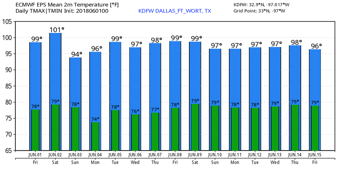 THE 2018 HURRICANE SEASON BEGINS TODAY - Today marks the first day of the 2018 Atlantic Hurricane Season, which will run until November 30. Long-term averages for the number of named storms, hurricanes and major hurricane are 12, 6, and 3, respectively.
The 2018 Tropical Cyclone names include: Alberto (already used), Beryl, Chris, Debby, Ernesto, Florence, Gordon, Helene, Issac, Joyce, Kirk, Leslie, Michael, Nadine, Oscar, Patty, Rafael, Sara, Tony, Valerie, and William. The Atlantic Basin is quiet today, and will continue to stay that way through next week. |
Archives
March 2023
Categories |
 RSS Feed
