
|
Light Freeze - Temperatures are in the upper 20s to mid 30s across the region this morning, and we will continue to stay in dry and mild conditions today. We project a high of 64 degrees, which is above the average January 30 high of 57 degrees. Due to abnormally low relative humidity values and gusty winds, fire weather concerns will return today and tomorrow for all of the DFW metro. The Rest of the Week Ahead - Tomorrow will be very windy and mild with highs in the mid 70s with a very sunny sky. We only stay that warm for a day, where we should fall back to the low 60s the next day. The next coldest morning of the week will come Friday, where we start the day in the low 30s, then we warm to the low 50s. A cold front comes through during the morning hours, which will bring a reinforcing shot of cold air during the day. The Weekend - Saturday will be a great day to do something outside. We start the day in the upper 30s, but we warm to the upper 50s with a good supply of sunshine. We trend cooler on Sunday, with signs of potential "wintery mischief" developing. The GFS has been exhibiting these signs over the past few days, but has not been consistent with the idea. Meanwhile, the reliable European global model continues to show a dry forecast. For now, we will stick with a dry forecast until we start to see consistency. The high Sunday will be in the mid 50s. Next Week - A cold front arrives on Monday, which will put us in the upper 40s for highs on Monday. But, we warm to seasonal averages for the rest of the week. The coldest arctic air will remain north of the state, with no signs of any terribly cold weather anytime soon. See the Texas Weather Discussion Video for more details. 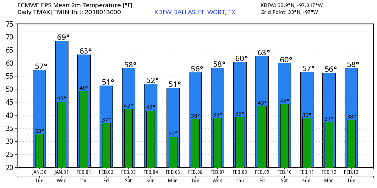 |
Archives
March 2023
Categories |
 RSS Feed
