
|
BITTERLY COLD MORNING - With temperatures in the low to mid 20° range, this is the coldest morning of the season for North-Central Texas. And we won't recover much during the day. We will only warm to the around 40° by the afternoon, with temperatures quickly falling by the evening. Some sleet/snow is possible for our extreme southern counties this morning. Some rain at times is possible during the early evening hours, with a very light wintery mix moving from the south. For North Texas, confidence is moderately high concerning the potential for sleet and/or a light wintery mix early this evening. Some of the mesoscale models shows accumulations of up to 1-2 inches for some spots in DFW. Let me stress that we do NOT expect any major accumulations, maybe 1/2" or a tad greater at best. I expect only a coating for most that get a mix. Additionally, some travel impacts will be likely, as this will most likely some through during the rush hour time period, which means traffic conditions will quickly deteriorate. Keep in mind that not everyone will see winter weather this afternoon, in fact, the best chance of a spot seeing sleet/snow this late afternoon/evening is basically 50/50. THE WEEKEND - Moisture may continue to advect from the north during the afternoon hours on Saturday, which would lead to rain at times during the afternoon. It will be very similar to today with afternoon highs in the low 40s with mostly cloudy skies. Some of the mesoscale models hint the another chance of freezing rain Saturday evening. We will mention a small chance of freezing rain, but nothing like this evening. We turn even wetter Sunday with afternoon highs in the mid 40s. NEXT WEEK - We begin to slowly moderate as we progress towards the latter half of the week. We will keep next week with partly cloudy skies with afternoon highs reaching towards the mid 60s by Friday. See the Texas Weather Discussion Video for more details. 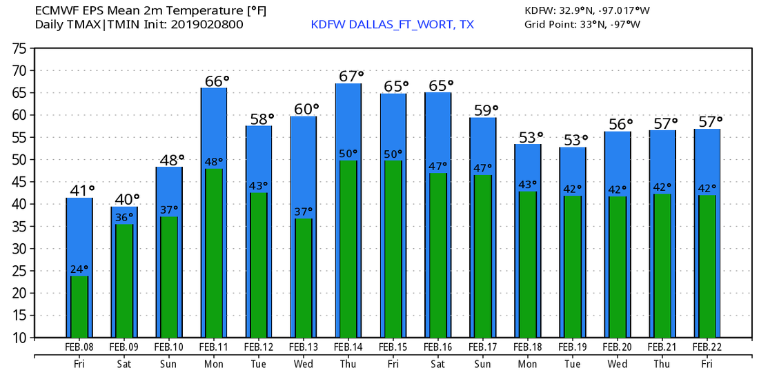 |
Archives
March 2023
Categories |
 RSS Feed
