
|
VERY MILD MORNING - Temperatures are currently in the 60° range across North Texas this morning, which surpasses our average low of 37° for early February. With a mostly sunny sky, temperatures will soar into the low 80s later today, which is above our average high of 58° for February 4. Tomorrow will be very similar to today; we will be down only a few degrees, and we will see more cloud cover. Tomorrow's low will be in the 60s; pretty similar to this morning. WEDNESDAY THROUGH FRIDAY - In advance of a cold front, showers and thunderstorms will become possible Wednesday afternoon through Thursday morning for North Texas. With anonymously high temperatures for early February, concerns for a few strong/severe storms are increasing, hence why the SPC has included some of the North Texas region in a "marginal" risk (level 1 of 5) of severe storms Wednesday afternoon and evening. 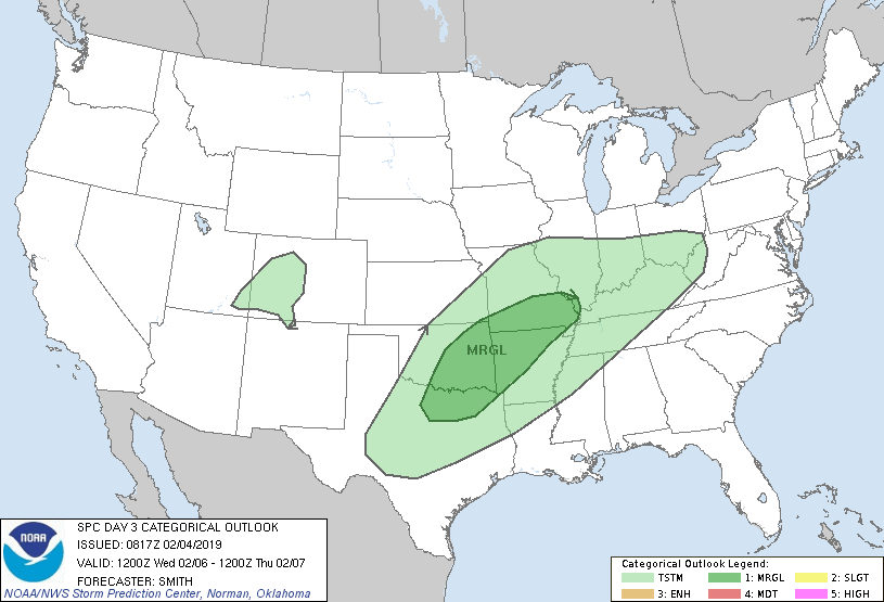 Other severe storms will be possible across the south-central US into parts of the Mississippi River Valley, but some of the strongest storms will be capable of producing some hail at times, and maybe one or two storms could have a couple of rotating updrafts by the evening hours. We are still more than sixty hours away from this severe storm threat, so continue to stay tuned for the latest details. For those that aren't in the severe weather risk, expect thunderstorms and rain at times Wednesday evening through Thursday morning. Amounts of only 1" - 1.5" is expected across North Texas, so I don't expect many flooding issues. Once the rain clears Thursday, temperatures will go the wrong way once we hit a certain point in the morning. We will peak mid-morning with temperatures in the mid 60s, then we will fall to the mid to low 40s by the evening hours with more clouds than sun. We start to catch a break from the rain on Friday, which should be a day featuring a mix of sun and clouds with highs in the mid 40s. Overnight lows may reach the upper 20s. THE WEEKEND - The first half of the weekend will be very chilly with cold air still locked in. We remain mostly cloudy for the weekend with highs in the mid 40s on Saturday. We warm to seasonal averages on Sunday, but may experience a few lingering showers. Highs will be in the mid 50s. NEXT WEEK - Some moisture may continue to linger Monday morning, but then we clear to mostly sunny skies for at least the early part of next week with highs in the 50s. At this time, we do not expect any significant winter weather issues for at least the next ten days.... See the Texas Weather Discussion Video for more details. 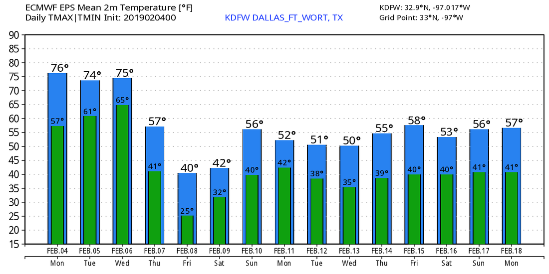 |
Archives
March 2023
Categories |
 RSS Feed
