|
FOGGY MORNING: Temperatures are in the 50s across the board in the North Texas region. With a combination of moist, warm air, places are experiencing dense fog this morning, and a Dense Fog Advisory remains in effect for all of North and Central Texas this morning. The sky will feature mostly cloudy skies, but the day will be mostly dry with only isolated showers about. A cold front will arrive this evening, which will set off showers, which will arrive this evening and persist into early Thursday morning. The best chance of rain will come during the early morning hours tomorrow, and highs will stay in the low 50s.
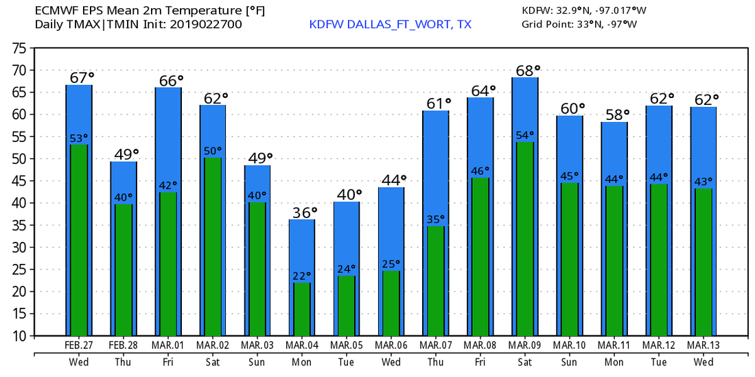
Then, on Friday, clouds should eventually dwindle down as we become mostly sunny with a few clouds in place... we currently project a high in the low 70s. THE WEEKEND: The overall forecast confidence in this weekend's forecast remains relatively low with a very sophisticated pattern across the South. Saturday will turn mostly cloudy and windy with a cold front coming through during the early morning hours. We will only reach the mid 50s by the afternoon with showers possible at times. The greatest threat of anything will come Sunday morning through the afternoon with the cold airmass in place. There is significant spread in the global model output, as the Global Forecast System (GFS) shows nothing but a cold rain with falling temperatures, while the European model (ECMWF) shows a cold rain after a brief period of light snow/mix. We will again trend towards the Euro's scenario and adjust the forecast to a colder, more precipitation prone day. Rain amounts over the weekend will be very light and will stay under a quarter of an inch for most communities. NEXT WEEK: Very cold arctic air will stay in place across the region. Highs will be in the 40s for the early part of next week with lows well into the 20s. Colder pocket around the DFW Metroplex could see upper teens by Wednesday morning. Temperatures moderate by the latter half of the week. See the Texas Weather Discussion Video for more details. |
Archives
March 2023
Categories |


 RSS Feed
