
|
Good afternoon all, Jonathan Williams here... As you likely have heard by now, there is a threat of winter weather as we move into the late part of the weekend. However, there is extreme uncertainty regarding if this even happens, amounts, impacts, and how widespread it would be. IF winter weather occurred, it will likely be able to stick and cause problems with a very cold airmass in place if there was enough precipitation. And that is a significant IF. And the models are split regarding how much precipitation there is. The ECMWF is more aggressive and shows widespread precipitation. Meanwhile, the GFS keeps it more isolated. Here is a detailed explanation from the NWS Office in Fort Worth, TX... NWS - Things start to get interesting (and perplexing) on Sunday. Another shortwave trough will move out of the Rocky Mountains, but this time, at a lower latitude than the one on Saturday. This shortwave trough will act to amplify a longwave trough that will be in place over much of the CONUS. The result at the surface will be a deep intrusion of arctic air across the interior CONUS, including here in North/Central Texas. This synoptic pattern is shown by both the GFS and ECMWF, but with significant timing differences. The ECMWF is faster, and perhaps a bit stronger than the GFS. The ECMWF also shows more widespread precipitation developing within the cold air, whereas the GFS is on the drier side. A closer look at the GFS however shows that parcels are near saturation with condensation pressure deficits generally less than 25 hPa. This means that it would not take much more synoptic-scale ascent than is being advertised by the GFS to result in the development of precipitation (it is no surprise that the ECMWF shows larger height falls, and has the more widespread precipitation). Given the "qualitative" assessment of the synoptic environment, we are inclined to lean a little bit towards the ECMWF. Some of the features within the synoptic setup include the aforementioned height falls, large PV anomalies around the 500 mb level, a 120+ knot jet streak, and conditionally unstable lapse rates. All of this is to say that there should be lift, and there should be cold air. The only question is will we have enough parcel saturation to get precipitation processes started. As you can tell, there is a lot of questions we will have to get answered before we can truly have a good handle on this situation. Similar to the NWS, we will lean towards the ECWMF solution. However, we are keeping winter weather chances on the low side until we have a better handle on this situation. Here is a look at our 10 Day Forecast... 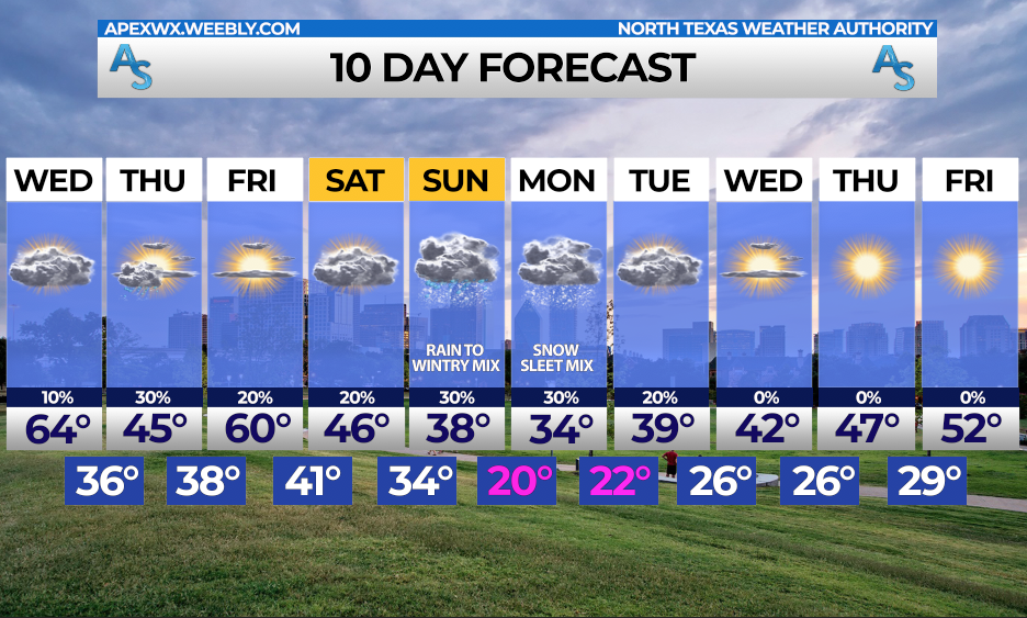 For now, we urge you to stay up to date on the forecast, as IF some of our models verify, we could see some impacts from this system.
Rain, freezing rain, sleet, and snow all seem like plausible scenarios, creating a difficult forecast for us. Stay tuned... Jonathan Williams Main Graphic Creator for ApexStorm NWS Weather Ready Nation Ambassador |
Archives
March 2023
Categories |
 RSS Feed
