
|
After a nice day today, things change heading into your weekend. Let's get into detail. As a cold front approaches tomorrow between 5-9pm, showers and storms are expected to fire up. Storms will have a decent shot of being severe with all modes of severe weather possible. The best severe risk is east of I/35. More isolated activity farther west, but still a threat of severe weather there. We turn sharply colder tomorrow night, before something really rare begins to occur. Yes indeed, some ice could make a comeback into the forecast, IN APRIL! Some of the latest guidance has us falling to near freezing Saturday morning, with some left over lift and moisture. 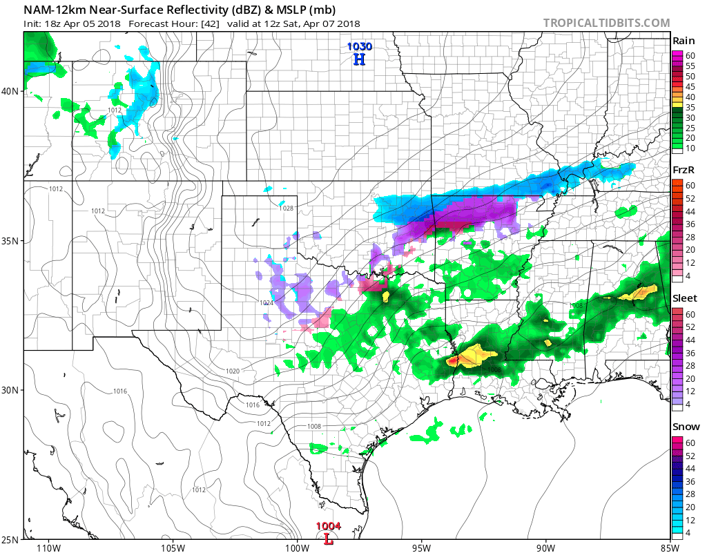 Some light rain may mix with light sleet or freezing rain across parts of the area. The more favored area will be northwest of DFW, but I cannot completely rule out some very light winter weather. Either way, no accumulations are expected at this time with maybe a slick spot northwest of the metroplex.
The NAM, which is more accurate with shallow air masses, has us only rebounding to the 40s Saturday afternoon. I'll have a high of 50° for now, but will adjust as needed. We dry out late Saturday and we quickly warm up Sunday. We start in the upper 30s, but reach the 70s by afternoon. Texas, stop drinking your beer! We remain warm anf mainly dry next week, with possibly some storms returning later in the week. Jonathan Williams Weather Forecaster Storm Specialist NWS/NOAA Ambassador COOL/CALM - Temperatures are in the mid to upper 40s this morning across the region. We will likely see these drop a degree or two in the next hour or so, but the sky will become mostly sunny with afternoon highs in the mid 70s. Friday - For most, the daytime should be dry with highs in the mid 80s by the afternoon. We will mention the chance of a random showers during the day. A strong cold front will push from the north during the evening, and scattered thunderstorms will accompany it. Some of those storms could turn quite severe with potential for all modes of severe weather. The Storm Prediction Center maintains the standard "slight" risk of severe storms for the DFW Metro and points to the east and south. 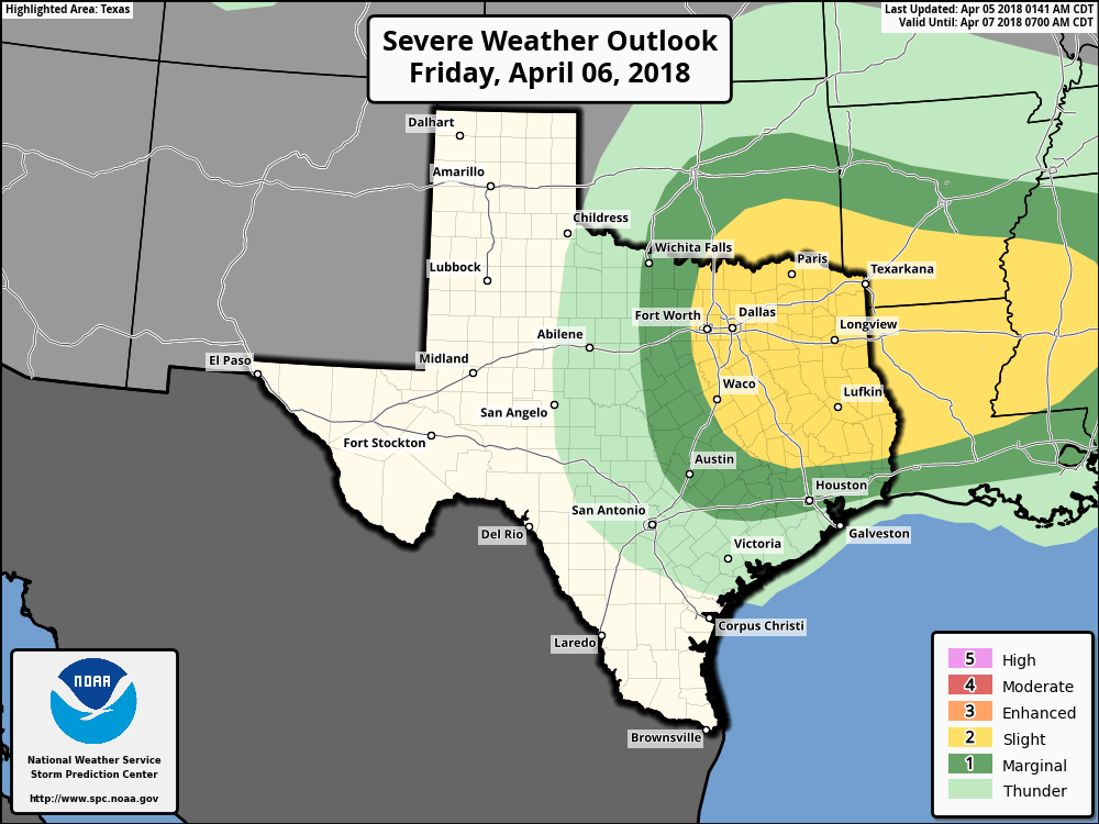 THREATS - As previously stated above, all modes of severe weather will be possible. The damaging wind threat will stay relevant to any storms that can stay along the cold front and remain in a cluster. The more discrete supercells will have the potential to rotate, producing large hail at times and a few tornadoes. Uncertainty regarding storm initiation ahead of the cold front precludes the risk for a more significant severe weather event. The more intense storms might stay to the southeast of DFW, where energy helicity is maximized. TIMING - A few showers will be possible during the day, then a strong cold front comes through at around 7-9pm, bringing severe weather on the backside of the front. Of course, we will still mention the potential for a few storms to develop ahead of the main front, so the peak hours for storms in DFW are around 6-10PM. Areas to the southeast - 7pm-12AM. We will continue to keep you updated as new information comes out. GROWERS BEWARE - As the cold front comes through, cold air advection will follow, which will make Saturday morning feel like winter to some extent. We will mostly be in the mid to upper 30s around sub-freezing temperatures, though some of the naturally cooler spots could see a light freeze in some places. A chance of a wintery mix exists later in the morning for some parts of Oklahoma and west Texas. After the morning, we will turn dry, but highs will only reach the mid 50s. We turn sunny again on Sunday with highs in the mid 50s NEXT WEEK - A great chunk of next week remains dry with a mix of sun and clouds with highs in the 70 degree range. After Saturday, we could be done with freezes for the rest of the season. See the Texas Weather Discussion Video for more details. 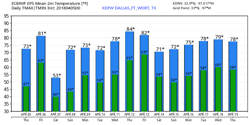 CHILLY START - You will need a jacket as you head to work or school this morning. Temperatures this morning are in the mid 40s across the region with light and variable winds. A chilly start will give off to a pleasant day ahead with lots of sunshine. Highs should be in the mid 60s. Tomorrow will be very similar to today; chilly mornings, pleasant days. We start the day in the mid 40s before warming up to the mid to upper 70s during the afternoon. FRIDAY AND THE WEEKEND - A cold front comes through during the day on Friday, and we will need to mention the chance of widely scattered showers and thunderstorms during the day. That activity will progress overnight, and we will likely see our main event Friday night/early Saturday morning. Some of those storms could be on the strong to severe side with hail and gusty winds possible. We do note that the SPC has defined the standard "slight" risk for much of North and Central Texas and points to the east.  It's still a bit too early to pinpoint exact timing of the storms, or the magnitude of the threat. We will have a good look at this risk later today or tomorrow morning. Highs should be low 80s on Friday. Saturday morning will be quite chilly due to a strong cold front moving through during the day on Friday. Some places could see lows in the mid to upper 30s with a light freeze possible for counties along the Red River. Once the rain clears in the morning, we will still only be in the mid 50s. The sun returns Sunday, and we should be back to the mid 70s. NEXT WEEK - Most of the week will feature cool nights and pleasant days with lots of sunshine. Highs will be in the mid 70s, very average temperatures going into mid April. See the Texas Weather Discussion Video for more details. 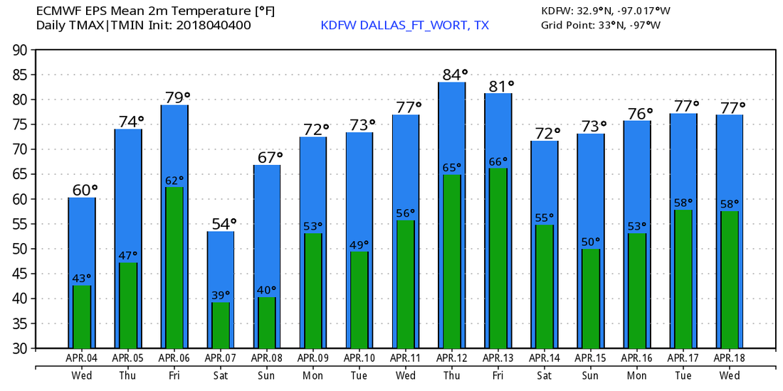 After the quick line of strong storms rolled in mid afternoon as expected, we have cleared out in the metroplex. Some storms produced up to quarter size hail and 50mph winds.
We will remain clear overnight with cold air settling in. We will fall to the upper 30s to lower 40s in the area. We will be sunny and nice tomorrow into Thursday with highs in the 60s tomorrow, with 70s by Thursday. A cold front will approach the area Friday with severe weather expected. This has the potential to be our first significant severe weather event of the season. A cold front will cause widespread storm development during the evening. We will have ample instability, and we will have extreme severe weather parameters. Stay tuned as this looks like our first significant severe weather event of the season. All modes of severe weather are possible. We will be cloudy and cold on Saturday with highs in the lower 50s. We rebound to near 70° on Sunday with scattered storms during the evening. A strong to severe storm is possible. Next week looks mainly quiet, but a few storms are possible later in the week. Jonathan Williams Weather Forecaster Storm Specialist NWS/NOAA Ambassador **No morning Texas Weather Discussion Video today. Weather permitting, we will try to do one this afternoon** Warm Morning - Temperatures are in the 64-70 degree range across the north Texas region with clouds out. The sky will remain mostly cloudy through most of the day with brisk northwest winds with highs in the low 80s. STRONG STORMS THIS AFTERNOON/EVENING - A line of strong to severe thunderstorms will develop in North Texas this afternoon. The SPC maintains a marginal risk of severe storms to the east of Dallas; a line from San Antonio to the east of Paris. 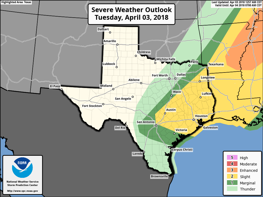 TIMING - The greatest risk of thunderstorms developing will come at around 1pm to 3pm. Based on relevant data, most of these storms will develop to the east of the metro and move towards east Texas, where their core threat is from around 4PM to 8PM. THREATS - In DFW, we are in the thunder zone, which means no organized severe weather is expected for the time being. Although if something does try to show up, the main issue will be strong straight-line winds and large hail at times. The risk of one or two isolated, brief tornadoes can't be ruled out in East Texas, especially in the "slight" risk area. RAIN AMOUNTS - Rain amounts for most will be in under a tenth of an inch. No flooding issues are expected. WEDNESDAY THROUGH FRIDAY - The sun comes back in full force on Wednesday, and will also be cool and comfortable with highs in the mid 60s. We warm substantially again on Thursday, this time with highs in the mid to upper 70s. Moisture returns on Friday, and we will introduce the risk for scattered showers and thunderstorms. It is also important to note that the SPC has outlined a risk for severe weather for Day 4 (Friday).  The Weekend - A few showers will stick around Saturday morning, then the rest of the weekend will be dry with a mix of sun and clouds. Highs will be in the low 70s on Saturday, and low 80s on Sunday. NEXT WEEK - Next week looks generally dry and sunny with afternoon highs in the 70 degree range. Rain could return during the latter half of the week. 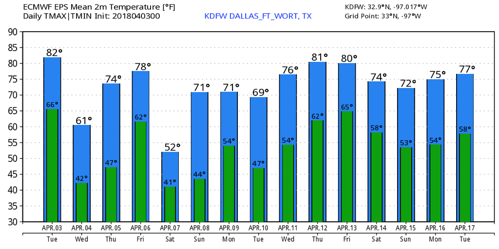 ON THIS DAY IN 2012 - A slight risk of severe storms was issued for mainly the DFW Metroplex. A severe thunderstorm watch was issued at around 9, but was upgraded to a tornado watch later in the morning. Past noon, two supercells developed and moved north. One moved through Lancaster and East Dallas, producing a tornado that would cause EF-2 damage, and another moved through Kennedale and parts of Arlington, producing a tornado that would also cause EF-2 damage. More storms formed that day, including the supercell that would produce EF-3 tornado damage in the Forney area. Fortunately, no one was killed from this localized tornado outbreak. Comment if you remember being in school in shelter in place when this happened!!
Temperatures right now are rising slowly into the lower to in a few spots the mid 60s, and this trend will continue into the overnight. Odd, huh! Why is this happening? A warm front is moving through the region currently.
Tomorrow near daybreak as the kiddos head off to school and you head off to work, you won't want that jacket! Unless you seem to always be cold, leave it at home! We will wake up near 70°F with humid conditions, along with some low level clouds. I don't expect much precipitation, but a few sprinkles or some mist isn't ruled out, which will just make it feel even more muggy. By mid to late morning, we will be near 75° with some clouds around, but some sun may be out. If this happens, the afternoon will be worse. I'll get to that in a minute. A cold front will be near Wichita Falls and will be penetrating south/east. We will be into the upper 70s heading into the lunch hour, with very humid conditions. I still don't expect much rain activity during lunch hour. But, things change mid afternoon. As mentioned, a strong cold front will he moving into the region. By 2-4PM, it will be near the metroplex. With significant instability approaches 4000, a severe storm risk will be with us. Scattered severe storms are expected to develop in the metroplex, with storm coverage near 30-50%. Storms that develop may produce large hail and damaging straight-line wind gusts, but an isolated tornado isn't ruled out. These storms will exit the DFW area after 6pm and will continue into our southeast counties. Some storms are expected into Central Texas, mainly along and east of a line from Waco to Austin. (I/35) Some of them may turn severe, primarily with damaging wind gusts and possibly some large hail. A tornado isn't ruled out well east of Waco/Austin. The cold front will bring in some colder air on Wednesday, with morning temperatures in the upper 30s. It appears unlikely for any frost due to low dewpoint values. We will only make it to the lower 60s Wednesday afternoon with a northerly wind. Sunshine is expected to be in abundance, but some high level thin clouds are possible, mainly after 1pm. Another weak disturbance will move through the Central Plains on Thursday, bringing some cumulus fields across the area. A stray shower or thunderstorm is possible north of DFW. Highs will be in the upper 70s. A strong cold front will move into region late Friday evening. A shortwave will also accompany this frontal boundary. Instability amounts won't be too terribly high, but they will suffice for a risk of strong to severe storms capable of damaging winds and large hail. The tornado risk looks fairly low, but it isn't zero. Some more showers and storms are expected Saturday morning, before we dry out and clear out with some much cooler air moving back in. Highs will only be in the upper 50s to lower 60s. We quickly warm up on Sunday however into the 80s. A few models have parts of the area into the 90s as well. What a difference 24 hours can make! Why will this happen? Strong southwesterly winds will quickly push out any cool air and allow us to shoot way up Sunday. With a dryline approaching from the west, some lift, moisture, and ample instability will allow for a few storms to develop. Some storms may turn severe. We dry out on Monday and we will be noticeably cooler with highs in the mid 60s to near 70°F. Jonathan Williams Weather Forecaster Storm Specialist NWS/NOAA Ambassador While it's been a chilly/cloudy day, things change heading into your Tuesday.
A warm front lifts northward overnight, bringing in warm and humid air tonight. We will wake up to the upper 60s to near 70°F with some very humid air. As I've been advertising in the past several days, a strong cold front will move in late tomorrow morning. Well, things have changed in newest guidance. The cold front in the past several days was expected to move in between 10am to the midday hour with isolated storms, some of which would be severe. In the newest model data, the cold front looks to move into the northwestern areas of the metroplex (i.e. Denton & Collin Counties) near 2-3PM. It will approach the immediate Dallas/Fort Worth area by 4-5PM. A squall line of storms will develop along this in Montague, Grayson, and Northern Denton and Collin counties. Storms may produce very large hail and damaging winds. We will watch the potential of discrete storm development in DFW and areas in Central Texas. Any of these storms will produce very large hail, damaging winds, and a threat of rotating supercells capable of tornadoes. The squall line of strong storms will be on top of the DFW metroplex by 3-5PM producing quarter to golf ball size hail, 65mph winds, and possibly a tornado or two. The storms will move southeast of the DFW area by 6-7PM. They will continue to produce a severe risk in East Texas and areas in East Central Texas. I have officially decided to issue a WEATHER ALERT DAY tomorrow for the DFW area. I will be issuing these on days of severe weather, extreme warmth or cold, flooding rains, or icy days or snowy days. This one obviously is for severe weather. We will have colder air Wednesday with highs in the mid 60s. Warmer air returns Thursday under partly sunny skies. A cold front will bring a chance of showers and storms on Friday, some of which may be severe. Some cool air returns Saturday with highs in the 60s after spotty morning storms. We quickly warm up Sunday into the 80s with a risk of isolated supercells. Severe weather is likely during this time. Jonathan Williams Weather Forecaster Storm Specialist NWS/NOAA Ambassador While it's been very cold this morning, we will slowly warm up this afternoon to the mid 50s. We may be lower or higher than this number depending on if clouds stay firm or they scatter out.
A warm front lifts north overnight, and temperatures rise to the lower 60s with moisture returning. As a cold front approaches the metroplex tomorrow early-mid afternoon tomorrow, isolated/scattered showers and thunderstorms are expected to develop. While only 30% of the area will see storms, with moderate amounts of instability, any storms that develop may pose a severe risk. The main threat in DFW will be large hail and up to 65mph wind gusts. The storms move southeast of our area after 4pm and we dry out and clear out. Lows tomorrow night will be in the mid-upper 30s. We will only reach the lower 60s Wednesday afternoon. On Thursday, a few more clouds may be in place ahead of our next system. A shower or storm isn't ruled out north of I/20 during the afternoon hours. No severe weather is expected at this time. On Friday as a cold front and strong disturbance collide over DFW, scattered to widespread showers and thunderstorms are expected. Some storms may be strong-severe during the afternoon and evening hours. A cold front brings in cooler air and post-frontal shower activity heading into Saturday with highs in the 60s. We made a very quick rebound next Sunday to the 80s, and isolated storms are likely to develop along another weak cold front. It looks likely that storms will pose a severe risk into this timeframe. Jonathan Williams Weather Forecaster Storm Specialist NWS/NOAA Ambassador Chilly Start - As we begin the first workweek of April, we start out pretty chilly due to a strong cold front that came through during the late afternoon yesterday. Temperatures are mostly in the low to mid 40s this morning. We should remain cloudy for much of the day with highs only reaching the low 60s at best. We will need to mention the chance of a few scattered showers during the afternoon, but most places will remain dry. Tomorrow - We turn much warmer as we start the day in the low 60s this time. Our chances of a thunderstorm turning severe are higher on Tuesday, especially within the standard "slight" risk for severe storms, defined by the Storm Prediction Center. 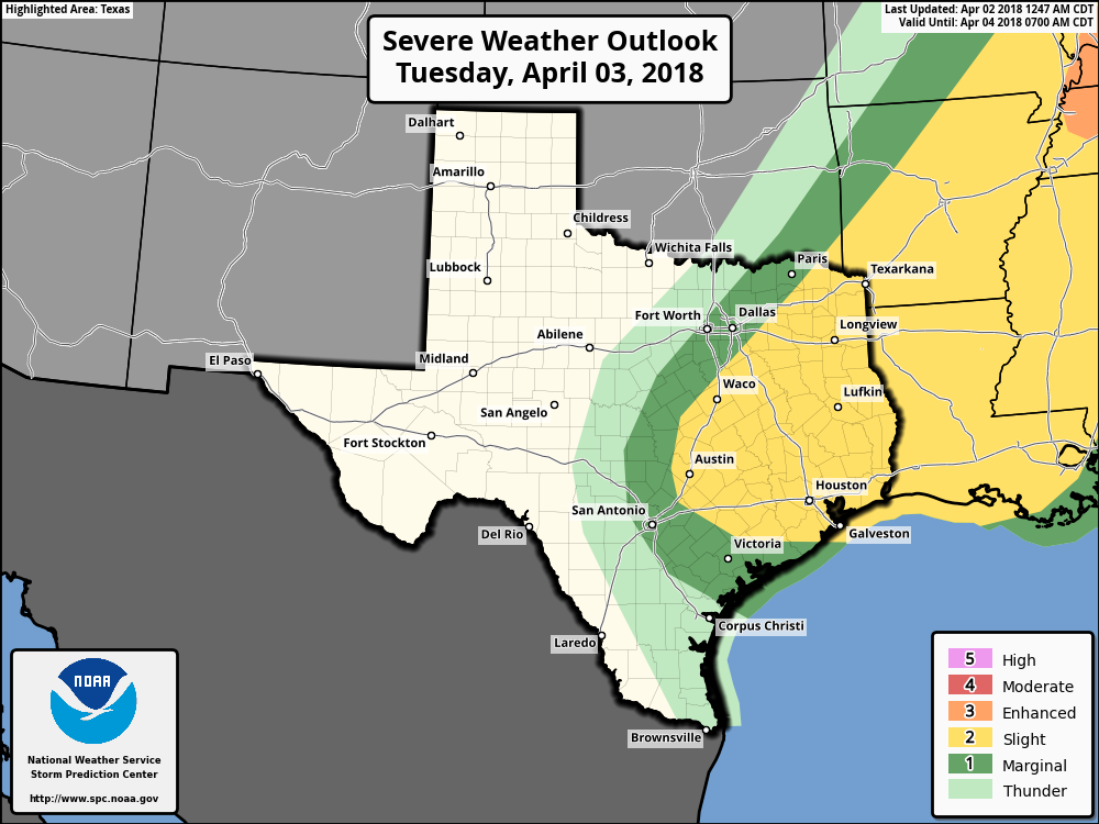 In DFW, we are outlined in the marginal risk for severe storms Tuesday afternoon and evening. Timing - If anything, we will see a band of rain develop towards noon & move to the east, then we will start to see storm initiation at around 3PM in East Texas once the cap breaks. These storms should quickly move to the east, so flooding should not be a concern. Threats - For DFW, the main thing we will have to worry about is damaging winds for any of the storms that can turn marginally severe. In the standard risk zone, damaging winds will be the prominent threat with the formation of a squall line. Steep mid-level lapse rates suggest that large hail will be possible that any storm that remains discrete or can maintain some rotation. A couple of tornadoes can't be ruled out along the warm sector or within the squall line itself. This activity should quickly push off to the east during the evening, and ETX will remain dry overnight. Wednesday Through Friday - We will remain dry until moisture returns on Friday. We will also begin a warming trend with high at around 64 on Wednesday, warming up to around 75 by Friday. We will also need to mention the chance of scattered showers and storms during the day on Friday with moisture returning to the region. The Weekend - We will see some showers try to stick around during the morning hours on Saturday, but the rest of the weekend will be pleasant and dry with highs in the low 70s on Saturday, warming substantially to the low 80s on Sunday. Next Week - The early part of next week looks dry and pleasant with highs mostly in the mid 70s. No signs of any significant severe weather at this time. See the Texas Weather Discussion Video for more details. 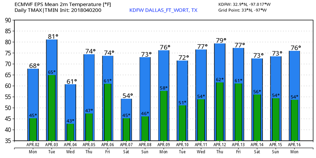 After a cloudy and cold afternoon today with current temps in the lower 50s, we stay this way tomorrow, except some rain is in the forecast.
As a disturbance approaches the western half of Texas, scattered showers and a few rumbles of thunder will roll into North Texas mid to late morning tomorrow. This will not be anything severe, but a few showers may produce some moderate rain at times. This has really begun to show up in some of the mesoscale models, especially the HRRR. Coverage is only expected to be 30-40%, but have the rain gear ready for some splash-n'-dash type of day. Highs tomorrow will struggle to reach the mid to upper 50s, with most areas in the lower to a few mid 50s, but a few areas may only stay in the 40s! Have the jacket/coat ready to roll out the morning door, because air temperatures may be in the 30s across the area. And NO, there will not be any winter precipitation tomorrow, but indeed some chilly temperatures will be around. A few models have us reaching the 60s tomorrow, but guidance has continued to trend colder and colder and colder. Therefore, we will lower highs to the lower/mid 50s. The frontal boundary will lift back north tomorrow night, causing for increasing temperatures overnight tomorrow and more moisture. Another cold front and a shortwave will approach the area Tuesday, and as these meet over DFW near midday, scattered showers and thunderstorms are expected. Some instability could support a few stronger storms will hail and strong winds. Some storms will be severe, mainly east of the Dallas/Fort Worth area. Large hail and damaging winds are possible in those areas, but that does NOT include the DFW area. Behind the front Tuesday afternoon, we will turn cooler with temperatures in the 60s. Clouds will be with us however through most of the afternoon. We will turn sunny and cool on Wednesday with cooler air and subsidence behind the boundary. Highs will be in the upper 50s and lower to mid 60s. Some clouds will move towards the area Thursday with a disturbance in the central plains, but we should remain mainly dry on Thursday, but an isolated storm isn't ruled out along the Red River during the afternoon. Severe weather is not in the forecast. As a cold front/shortwave move toward the area Friday, numerous showers and thunderstorms are posed to develop, mainly after 2PM. Strong to severe thunderstorms are in the forecast during this timeframe, as CAPE will be quite excessive during the day. Large hail, damaging winds, and tornadoes are possible. Highest severe risk looks to be north of I/20. A few showers are possible early Saturday morning, but clearing skies will occur late morning into the afternoon with drier air and subsidence moving into the region. Highs will be cooler in the 60s. We warm back up quickly Sunday with highs approaching 80°F by the afternoon hours. We look to turn active with frequent severe risks heading into the week of the 9th-16th. Jonathan Williams Weather Forecaster Storm Specialist NWS/NOAA Ambassador TODAY: Cloudy and warm through 3PM, then turning colder and remaining cloudy this afternoon. High: 74°F but falling to 54°F by 6PM.
TONIGHT: Cloudy and cool with scattered drizzle/light rain. Low: 43°F TOMORROW: Cloudy and cool with a chance of showers. (30%) High: 58°F TUESDAY: A cold front moves into the area late morning into mid afternoon. Strong to severe storms are possible. (50%) Large hail and damaging winds possible. Most likely time for storms is between 12PM-3PM. Storms shift southeast of the metroplex late afternoon/evening. High: 73°F WEDNESDAY: Mainly sunny and cool. Brisk northerly winds will be in place. High: 62°F THURSDAY: Partly Sunny skies with a chance of a thunderstorm east of I/35. (10%) Warmer. High: 74°F FRIDAY: Scattered showers and storms during the morning, but thunderstorms likely late afternoon into the evening. (60%) Storms may be severe during the afternoon. Warm and humid. High: 78°F SATURDAY: Partly Sunny with scattered showers and thunderstorms expected. (50%) High: 65°F SUNDAY: Mostly Sunny skies and warmer. Breezy. High: 76°F Overall, we remain active over the next seven days, but some days will be dry. Any storm on Tuesday/Friday will pose a severe risk. Jonathan Williams Weather Forecaster Storm Specialist NWS/NOAA Ambassador Clouds are in abundance right now, and they will stay that way all day. A few spotty showers are possible this afternoon as a cold front moves through the region. Temperatures will fall into the lower 50s late afternoon and evening. Grab the coat!
Overnight, we will fall to the lower 40s and a few mid 40s across the area, with even a few 30s in isolated spots north/west of the metroplex. A few 50s aren't ruled out in the warmer areas. (Heat island affect of Dallas) Heading into your Monday, we have a tricky forecast in play. If the front doesn't lift back north, we will be cold and dreary all day with highs in the 40s & 50s. If it does lift back northward, we will warm to the mid 70s with isolated severe storms developing late afternoon with CAPE near 2000 late afternoon as very weak lift moves into the area. I apologize for the inconvenience for not really knowing what will happen, due to models having very little agreement of what happens tomorrow, therefore making me have to give you the 2 scenarios that will play out. For now, time will tell. Either way, the front will be north of us tomorrow night and we will be in the 60s (rising temps overnight if cold solution or steady temps in warm solution) with a threat of a storm or two. No severe weather is expected at this time. As another front and dryline approach us early Tuesday afternoon, scattered showers and thunderstorms will develop. CAPE at 2PM will be near 3000, so any storms may turn severe quickly. The main threat will be very large hail, but damaging winds and a tornado is possible. The threat will shift south/east of the metroplex late afternoon and evening. Some of the timing is uncertain, so I'll keep you updated. Cooler air and subsidence will move in Wednesday leading to sunshine and highs in the lower 60s. We warm up on Thursday with partly sunny skies with highs in the 70s. A stray thunderstorm may develop in the afternoon. Our next system and frontal boundary moves in next weekend, with a chance of showers and thunderstorms Friday into Saturday. A few severe storms are possible Friday &a Friday Night. Some cooler air will move in Saturday with highs back into the upper 50s. Jonathan Williams Weather Forecaster Storm Specialist NWS/NOAA Ambassador |
Archives
March 2023
Categories |
 RSS Feed
