
|
*No Texas Weather Discussion Video today* COOL START - Temperatures are currently in the upper 40s to the low to mid 50s across the region this morning. That's about 5 degrees below the average low for mid April. Today will be a very pleasant day but very mild with highs in the low 80s this afternoon. Winds may turn a little gusty this afternoon with a south wind of 20-30 mp/h. Tonight will feature mostly fair skies with overnight lows in the low 60s. We continue a warming trend through Friday, and Thursday should be mostly sunny with highs in the mid 80s this time. FRIDAY - This should be the warmest day of the warming series this week. We start the day in the upper 60s, ending up in the mid to upper 80s by the afternoon. A cold front and a dryline pushes east during the day, and we might see storm initiation along the dryline. You know what that means. Another severe weather risk is in place for Friday the 13th... 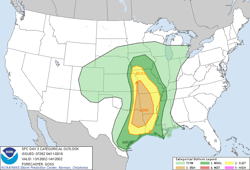 The Enhanced risk extends from Lufkin, Texas to the south of Kansas City. The standard "slight" risk of severe storms extends all the way from Houston to the east of Lincoln, Nebraska. The marginal risk clips areas along and east of the I-35 corridor. TIMING - A morning round of showers and storms is likely during the commute to work and school on Friday. Some of those storms could turn strong and produce at least some gusty winds. As they progressively move to the east, they will start to intensify over time in parts of extreme East Texas through parts of Missouri and Arkansas. As the cold front moves to the east during the afternoon, more development is possible. Once you start feeling cooler air and the front is to the east of you, the risk for thunderstorms for your area is over. THREATS - Storms will start out in a discrete mode at first, posing a risk for mainly large hail and a few tornadoes along the warm sector. The risk for damaging winds comes when the storms begin to transition to more of a linear mode. But keep in mind that most places in North Texas are under a marginal risk or no categorical risk of severe storms, so a few strong cells can pop out, but nothing too widespread. RAIN - Rain amounts will likely stay under 1/2 inch in most places, so flooding will not be an issue. THE WEEKEND - Looks like this weekend will turn cool and pleasant with sunshine in full force. High will only reach the low 60s due to cold air advection from the cold front. We start both days in the 40 degree range. NEXT WEEK - The early part of next week looks dry with cool night and pleasant days ahead featuring mostly sunny skies. Some rain can creep back in during the latter half of the week, but its too early for specifics. 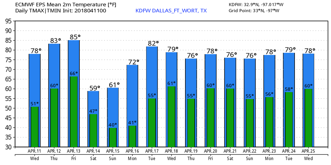 |
Archives
March 2023
Categories |
 RSS Feed
