
|
LOOKING UP - The deep upper surface low that brought heavy rain and severe storms to parts of North Texas this weekend is over Tennessee this morning. The heavy rain and thunderstorms is well off to the east of us and is affecting parts of the Carolinas and the east today. Today will feature a sunny sky with a afternoon high around 82 degrees. MIDWEEK - Scattered showers will remain possible tomorrow as a cold front comes through during the afternoon. The good news is, this will be mainly in the form of rain showers, so no severe weather is expected and not much thunder is expected, either. Just a classic rainy afternoon across the region. We turn breezy and cooler during the day with highs only in the mid 60s during the afternoon. We should go back to mostly sunny skies on Thursday with highs in the mid 70s. FRIDAY OUT - Looks like the magic day plus the weekend will turn out pleasant and dry with lots of sunshine and pleasant nights. The high on Friday will be in the low to mid 70s, warming up to around 80 during the weekend. NEXT WEEK - For the first week of May, most of the week looks mostly cloudy and dreary with a chance of occasional showers and thunderstorms, especially during the latter half of the week with highs in the low 80s. We will need to monitor the potential for severe weather in the southern and central Plains, especially during the latter half of the week going forward. See the Texas Weather Discussion Video for more details. 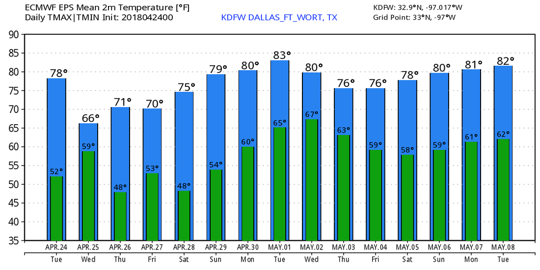 |
Archives
March 2023
Categories |
 RSS Feed
