
|
LIKE A LATE SPRING MORNING: It feels very comfortable outside this morning as temperatures sit in the mid 60s across much of North Texas. If you didn't know any better, you would think that we are in April. However, we all know that when it is this warm for a period of time with a severe weather threat on the horizon, not so good things tend to happen, but let's hope that doesn't happen today. SEVERE STORMS IN TEXAS TODAY: New data coming in this morning maintains the idea of a potent severe weather setup for much of North and Northeast Texas today. The storm system will feature developing strong wind field with the low level jet (5,000 feet off the ground) being in the 50-80 knot range, making for a windy day in East Texas and relatively high storm relative helicity indices (veering of the wind with altitude in relation to storm motion). The SPC has areas to the east of Dallas (including Garland and Rowlett) in a "moderate risk" (level 4/5) of severe storms, while the rest of the metroplex and much of Central Texas falls under the "enhanced risk" (level 3/5) of severe storms, while the standard "slight risk" (level 2/5) extends right through San Antonio through Wichita Falls.  As I always say with any threat of severe storms, please don't get caught within the risk categories or colors. Just be advised that all of North Texas has a risk of severe thunderstorms today. With all of the hype that social media tends to bring, I know that some people that look at that stuff suffer from storm anxiety already, which only makes matters worse. Just understand that even with a significant severe weather day looming over our heads, the chance of one particular spot being affected by hail or even a tornado is still quite low. Just like any severe weather threat, be prepared and you will get through the evening just fine. TIMING: The main window for severe storms over the metroplex will come from around 2 PM to 9PM when/if the cap erodes on time, and 7PM till Saturday morning for most of the moderate risk area. This will generally be a evening/nighttime event. THREATS: Discrete thunderstorms will develop during the late afternoon with potential for very large hail (especially in the Metroplex) and a few tornadoes. Based on specific forecast soundings, I wouldn't be too surprised if we see a strong tornado or two (EF2 or higher) across North and Northeast Texas. However, the main event will come from damaging straight-line winds for much of East Texas and beyond. Some hurricane-force winds is possible for interests in East Texas. Away from the severe weather threat, the pressure gradient will already be fairly high during the day, with winds averaging 15-30 mph with gusts to 40 mph. A wind advisory has been issued for much of East Texas today. RAIN: Rain amounts today should be around 2-3 inches for much of the region with some flooding issues possible. We note that a flash flood watch is in effect for much of the DFW Metroplex and points northeast. CALL TO ACTION: Everyone will need a great way of getting severe weather warnings throughout the afternoon and evening today if needed. Make sure WEA ("emergency alerts") are enabled on your phone. Make sure to have a NOAA Weather Radio in your home and business. NEVER RELY ON AN OUTDOOR SIREN. Just be sure to double check the safe place in your home; a small room on the lowest floor near the center of your house, away from windows. Make sure every person in your home knows where that safe place is, and you have helmets for everyone that lives there. Make sure to have a portable air horn, as well as heavy duty shoes. YOU CAN NOT STAY IN A MOBILE HOME IF YOU ARE IN A TORNADO WARNING. In this situation, know the nearest shelter that is available. ARE TORNADOES UNCOMMON IN JANUARY? Not really. We have seen 43 tornadoes in January since 1880, which goes to show that these events can happen any time of the year. We may experience a light wintery mix tomorrow morning with no travel impacts. Other than that, we clear for the weekend with highs in the low 40s tomorrow and upper 50s on Sunday. NEXT WEEK: Most of next week remains dry with a mix of sun and clouds, featuring highs in the upper 60s for at least the beginning of the week. See the Texas Weather Discussion Video for more details. 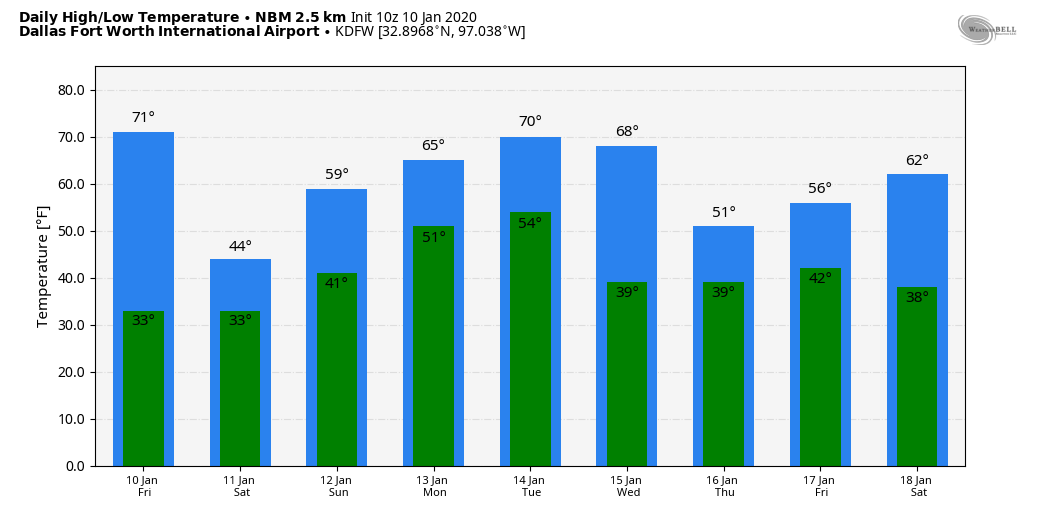 |
Archives
April 2024
Categories |
 RSS Feed