
|
ANOTHER CLASSIC SUMMER DAY: This is honestly what we expect in summer in Texas. Another day of classic summer weather with lots of heat and humidity is expected with highs basically at the century mark. I know this is basically the same forecast over and over and over again, but I promise subtle change will come over time. But for now, another Heat Advisory remains in effect for this afternoon, so you can expect another afternoon with heat indices in the 105-110° range. Not much change tomorrow. Although we might not quite hit the century mark tomorrow, the humidity levels will increase, so it will still feel just as hot as the past few days. Mostly sunny skies are still forecast. FRIDAY AND THE WEEKEND: A weakness in the ridge will allow for a surface front to attempt to push through the region Friday night, when we will introduce a chance of isolated to scattered showers and storms beginning Friday evening, lasting through Saturday during the day. Not everyone will receive rainfall. Look for a mix of sun and clouds each day. Heat levels will be slightly lower due to increased cloud cover. Highs will be in the 95-99° range. NEXT WEEK: We will briefly continue to maintain our hot pattern for the beginning part of next week as the upper high continues to dominate our region. There is evidence of a pattern shift for much of the Central Plains by the latter half of next week, which would allow a surface front to move through the region by Wednesday or Thursday, allowing for greater chances of rain and a cooling trend. But expect routine summer weather conditions before any of that. See the Texas Weather Discussion Video for more details. 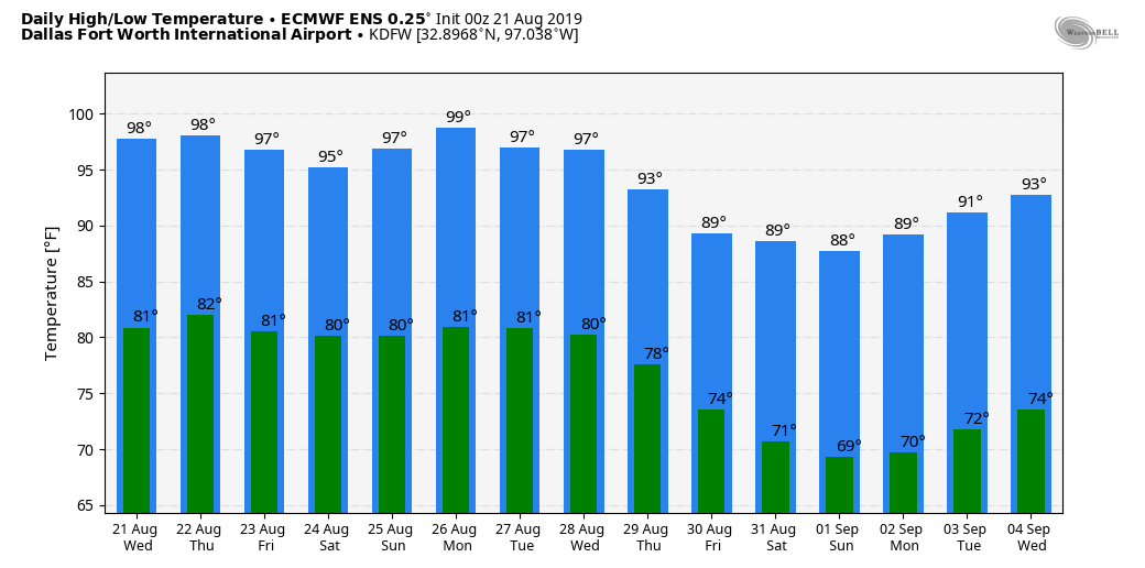 TROPICAL STORM CHANTAL FORMS IN THE NORTHERN ATLANTIC: Rapidly developed, Chantal is a tropical storm in the Northern Atlantic, away from land. It is expected to stay far away from any land, continuing to meander in the North Atlantic until it becomes post-tropical this weekend. The rest of the Atlantic Basin remains quiet.
|
Archives
March 2023
Categories |
 RSS Feed
