
|
SUMMER WEATHER CONTINUES: Look for hot and humid weather again today across North Texas with a partly sunny sky and afternoon temperatures in the 100° range. Like yesterday, the heat indices will be in the 105-110° range this afternoon with a nice, upper-level high parked right on top of us. A Heat Advisory remains in effect for most counties in North Texas. Some counties to the west have been trimmed away from the advisory, but just realize that everyone will remain very hot for the time being. The weather won't change much tomorrow as the classic summer pattern continues. THURSDAY THROUGH THE WEEKEND: The upper high pattern will still persist. However, weak impulses from the High Plains and parts of the Central Gulf Coast will keep much of the region dry for the rest of the work week. However, the abundance of the impulses will work to slowly weaken the ridge parked over us, and temperatures should fall in tandem to the weakness of the ridge. Highs will be in the upper 90s for Thursday and Friday, followed by mid 90s for the weekend. The weakness will allow for a surface front to drop into the region by Friday, allowing low chances of spotty showers and storms mainly Friday night through Saturday morning, but also during the day on Saturday. We stay mostly dry on Sunday, and each day should be filled with mostly sunny skies and subtle increasing cloud cover. NEXT WEEK: The last week of August features seasonal temperatures with the main upper level ridge well to the west of us by Friday. Highs will be in the mid 90s all week, but we end up at around 90-93° by Friday with lows in the mid 70s. See the Texas Weather Discussion Video for more details. 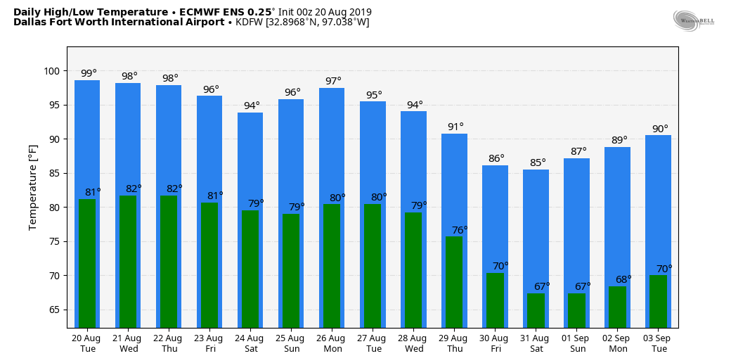 |
Archives
March 2023
Categories |
 RSS Feed
