
|
RADAR CHECK: Most of the showers and thunderstorms have pushed out of the North-Central Texas region this morning, leaving only a cluster of thunderstorms just south of the Red River. We do note that those storms have triggered a Flash Flood Warning to be posted for a portion of Cooke and Grayson counties until 11:00 AM this morning. For the coverage area this afternoon, I expect mostly dry conditions with a mix of sun and clouds with highs in the middle 70s. However, I can not rule out the potential for a stray thunderstorm or two. Most of our potential third round of heavy rain and strong to severe storms will come during the overnight hours, however. SEVERE RISK FOR MOST OF NORTH AND WEST TEXAS THIS EVENING AND TONIGHT: Current surface analysis reveals a surface low over southwestern Kansas with a quasi-stationary front stretching down to the south across west Texas, extending further to the east across North-Central Texas. The warm sector is characterized by dewpoints in the middle to upper 60s with temperatures reaching the mid to upper 70s in most spots this afternoon. The rich boundary layer in the Big Country combined with daytime heating instability (especially with the sun being out) will cause a risk of severe weather this afternoon and evening for northwest and north-central Texas. The SPC (Storm Prediction Center) has an "enhanced risk" (level 3/5) of severe storms for most of the Big Country and for areas generally north and west of I-35W. The standard "slight risk" (level 2/5) runs through the DFW Metroplex, generally surrounding the Enhanced Risk for about 100 miles apart. Lastly, a "marginal risk" (level 1 of 5) runs through the rest of the North Texas area, extending down towards Central Texas. 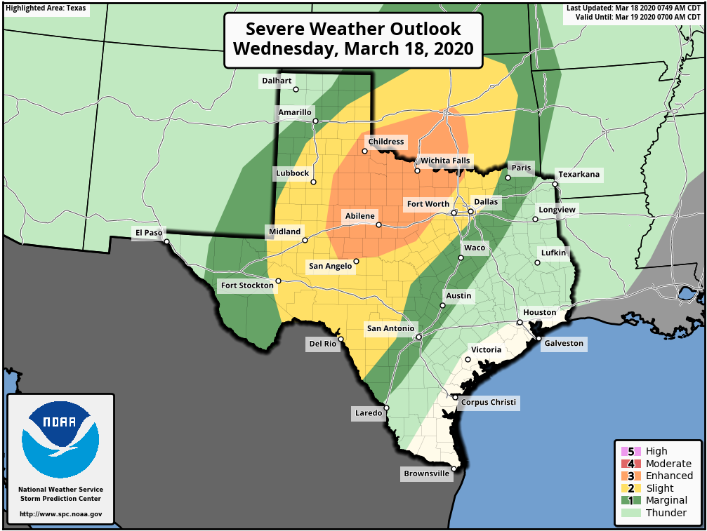 TIMING: Most of the development will take place along the dryline in West Texas at around 5-6PM. The any discrete storm will consolidate into an MCS (mesoscale convective system) later overnight. The severe risk in the North Texas region will run from about 9PM-12AM, with the risk of heavy rain running from midnight to the pre-dawn hours.
THREATS: All modes of severe weather will be possible, just like yesterday night. Large hail and damaging winds will be the primary risk. However, a couple of tornadoes will be possible, like what we saw in Throckmorton yesterday afternoon. There is still a little bit of uncertainty regarding the extent of the spread of heavy during the early morning hours. One of the mesoscale models keeps most of the activity confined to North Texas, while one of them keeps the rain widespread through North and Central Texas. Nonetheless, please keep in mind that North Texas has the best chance of severe with heavy rain chances, which may lead to localized flooding. TOMORROW: The threat of strong to severe thunderstorms will continue tomorrow for our northeastern counties as activity develops from a remnant outflow boundary. Associated lift should support the threat for large hail and damaging winds for those zones. Flooding will be a continued issue in already saturated areas. FRIDAY: Things cool off considerably Friday with a cold front pushing southward late Thursday night into Friday with highs in the 50s and 60s. An upstream shortwave will approach from the south, which will add another chance of showers and thunderstorms which should affect our southernmost counties. Flooding should not be much of concern by that point. We should get a break from the rain Saturday and for most of Sunday with highs in the mid 50s. We will see mostly sunny skies Saturday followed by cloudiness on Sunday. Please keep tabs on our twitter and Facebook page, as we will be updating frequently. Donovan Neal |
Archives
March 2023
Categories |
 RSS Feed
