
|
ALREADY FEELS LIKE A SPRING AFTERNOON: Temperatures are mostly in the middle 80s this morning across North Texas, which would probably be our high temperature if we were in April. We project highs to be above 100° again for the region with heat indices around the 110° area. A Heat Advisory remains in effect for all of North Texas, but an Excessive Heat Watch is in effect for the DFW Metroplex and for areas to the east of US 281. How today goes will determine if we stick with a Heat Advisory or issue an Excessive Heat Warning for some areas. Not much change is expected tomorrow. We will be a few degrees hotter with highs around mid triple digit range. MIDWEEK: A mid-August cold front sweeps through here by late Tuesday night, which will bring the chance of scattered showers and storms through Wednesday morning. Not everyone will see rain, as the best chance of a spot getting wet is only one in three. But the good news is we will not be baking as much. Highs will be in the mid 90s for a couple of days, which is near our seasonal averages. FRIDAY AND THE WEEKEND: Unfortunately, we will go back to our same prolonged hot and dry pattern as before, except the upper-level high will not be as strong as it is now. It will still be very oppressive with highs in the upper 90s, but dewpoints will make it feel like 100-105°. Another Heat Advisory will likely be needed to address this potential. NEXT WEEK: Another week of prolonged hot and dry weather is expected with highs in the upper 90s for most of the week with overnight lows in the upper 70s. We begin to cool down towards the end of the month with temperatures regularly in the mid to low 90s. See the Texas Weather Discussion Video for more details. 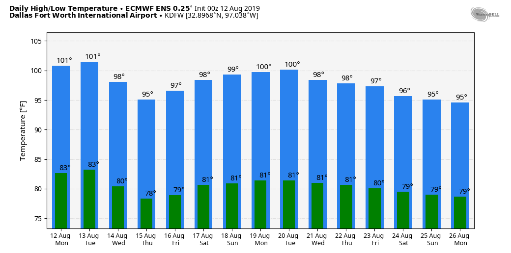 |
Archives
March 2023
Categories |
 RSS Feed
