
|
CALM SPRING WEATHER TODAY - We project a high in the 76-81 degree range across North Texas this afternoon under a mostly cloudy sky. While there is moisture surging south from the Gulf, an upper ridge and a strong cap will keep the region mostly dry today. However, an isolated shower or two can not be ruled out this afternoon, but the chance of any one spot seeing rain is only 5-10%; not really worth mentioning in any forecast. ACTIVE WEATHER PATTERN BEGINS TOMORROW - A substantial shortwave is expected to lift northeastward across the south-central High Plains during the pre-dawn hours tomorrow, setting the stage for an active severe weather day from Iowa down to the South Plains in the afternoon. 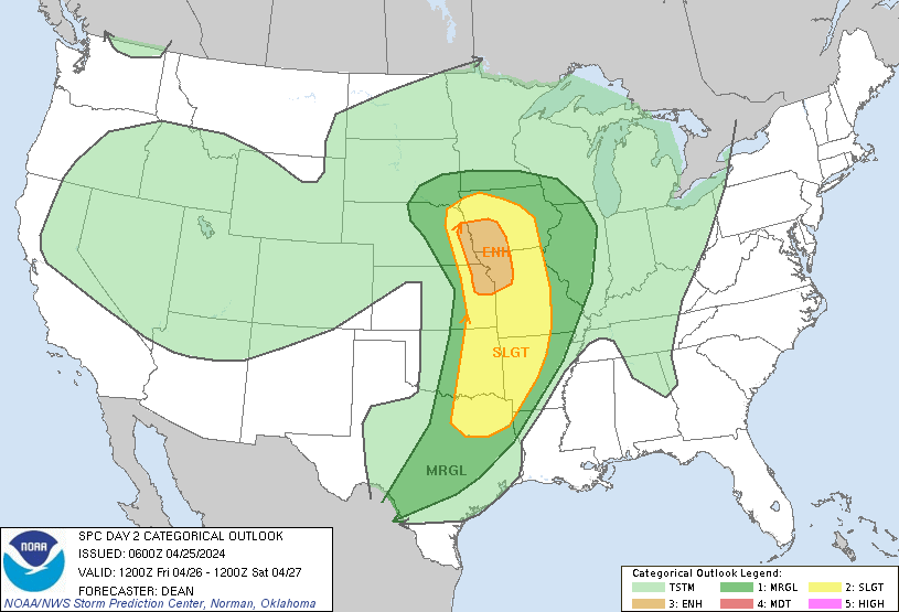 While the greatest threat of severe weather remains well to the north of North Texas, we do note the standard "slight" risk (level 2/5) of severe storms in DFW metroplex, extending as far south as Corsicana and up north through the Ark-La-Tex region. 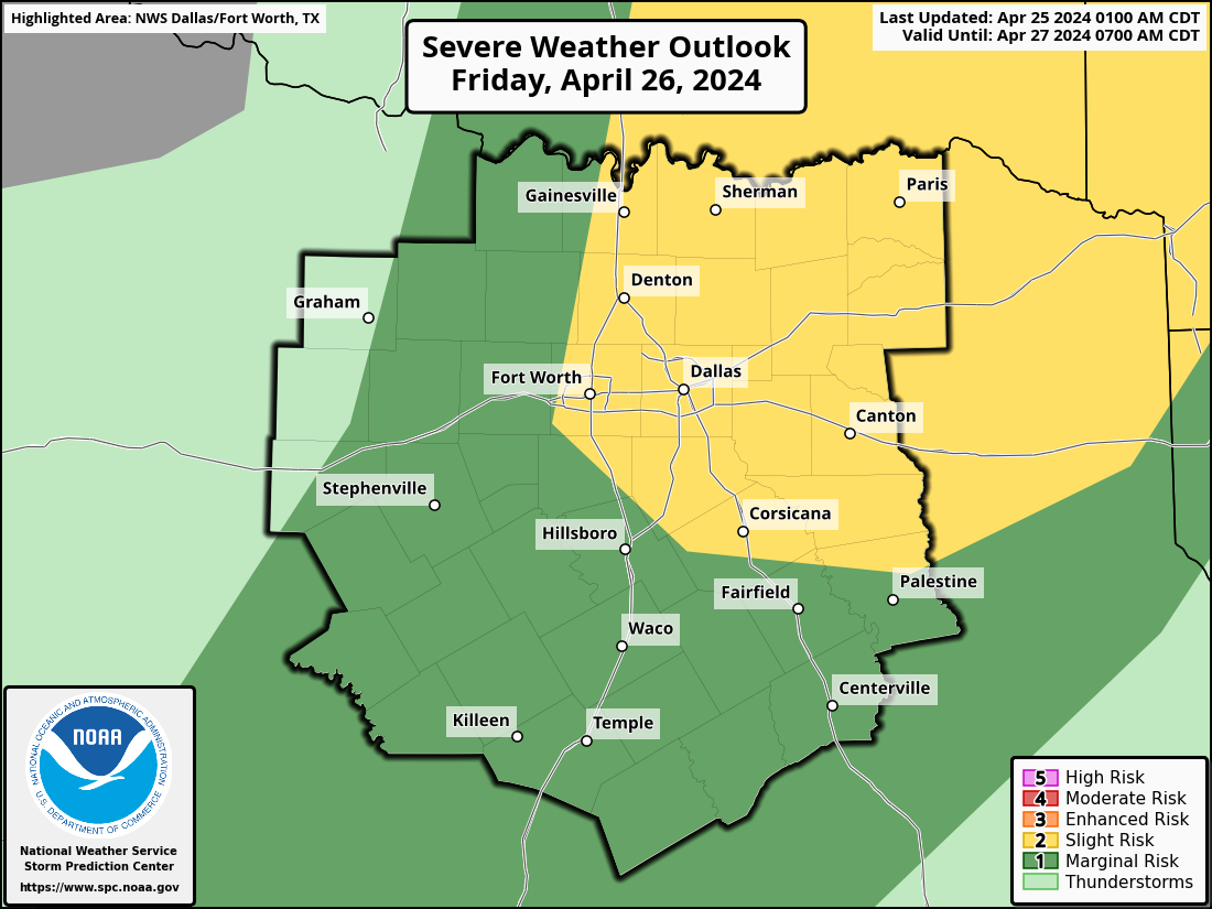 FRIDAY MORNING - The passing of the Pacific front in addition to a weak cap should allow clusters of strong to severe storms to develop near Abilene during pre-dawn, moving northeastward into the metroplex right in time for morning rush hour. As typical with these severe weather threats, large hail and wind damage remain the most primary concerns, however, an isolated tornado is definitely not out of the question. 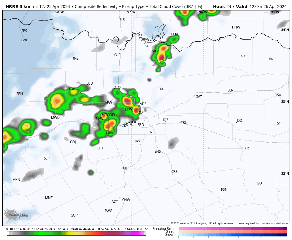 HRRR (High-Resolution Rapid Refresh) model valid tomorrow at 7:00a. Once morning convection pushes past the region, clouds will exit the region early in the afternoon, which should allow temperatures to warm to the 85-90 degree range. THE WEEKEND - As a negatively tilted trough provides dynamic support while moisture from the Gulf surges northward, the stage will be set for what could be a classic Central Plains tornado outbreak Saturday afternoon and evening across Central Oklahoma and Kansas. Currently, there is an "enhanced" risk (level 3/5) of severe storms for that region, however, it is a matter of when, not if, higher severe probabilities are introduced for the region in question over the next couple of days., 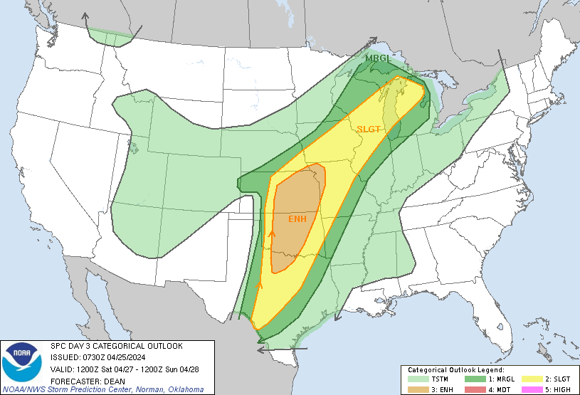 While the greatest threat of severe storms once again remains well to our north, the enhanced risk remains to the north and west of the metroplex, while much of the region maintains the standard "slight" risk of severe storms. 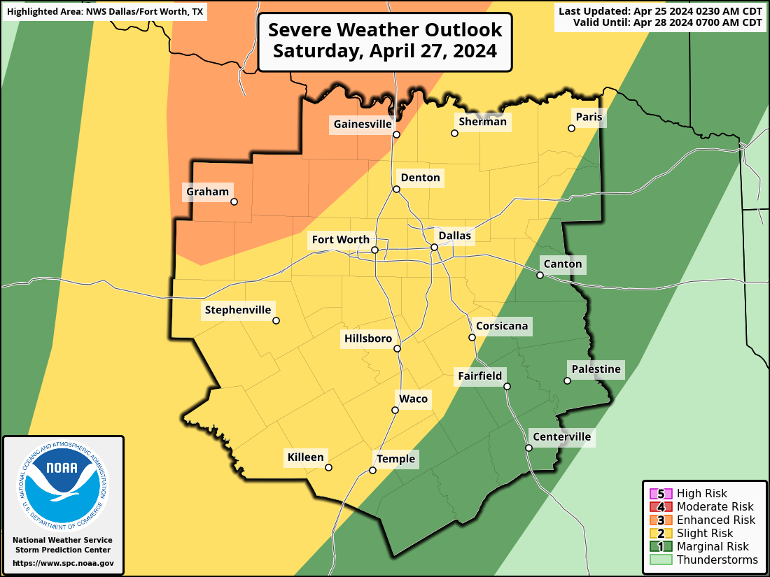 SATURDAY - While the risk for storms tomorrow morning is very clear, Saturday presents a complex forecast, one that can not be properly communicated through the use of common weather apps. At this time, morning showers appear possible Saturday, but it is unclear the extent of how numerous these showers may be. This can very well play a role in how severe afternoon/evening storms become. If there is minimal convection in the morning, severe thunderstorms become more likely in the afternoon/evening as the environment need not "recover" from morning convection. In this case, a few supercell thunderstorms will be possible with the potential for large to very large hail stones and perhaps a couple of isolated tornadoes. It is still too early to determine exact placement of the front to ascertain start time of severe storms. Not everyone will see severe weather this weekend, however, widespread rain becomes likely Saturday night into Sunday late morning, especially for those closest to the Red River. Rain amounts will range from 1-2" regionwide with potential for 3"+ measurements along the Red River where storms have more potential to train through the night. We also note the possibility of overnight flooding. The Weather Prediciton Center has a "slight" risk of excessive rainfall for North Texas. 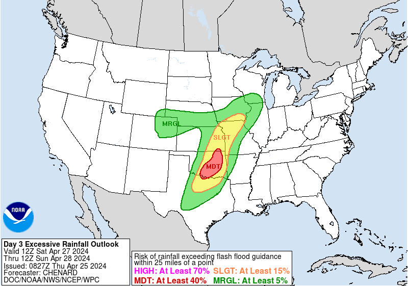 Once rain exits the region in the afternoon, clouds will begin to clear from west to east. We project a high in the low 80s. NEXT WEEK - Active weather continues into the next week multiple rounds of thunderstorms likely throughout at least the early week. Monday and Tuesday evening along with Wednesday afternoon will pose multiple chances of storms, However, confidence is too low to mention any severe probabilities at this time. 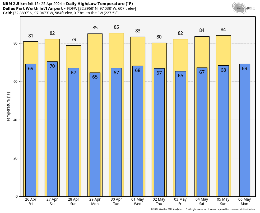 ON THIS DATE IN 1994 - A localized tornado event, part of a multi-day Central and South plains tornado outbreak, spawned 6 tornadoes in the metroplex. Four of them, rated F0, caused minimal to no damage across Ellis, Dallas, and Tarrant counties. However, an F2 tornado touched down in DeSoto, damaging over 200 homes, a school, and City Hall. Damages were estimated at $50 million from this tornado. Lastly, a 1/2 mile wide F4 tornado destroyed 80% of historic downtown Lancaster, killing three people and injuring 48 people.
Donovan Neal Owner - ApexStorm WARM START TO APRIL - Today will be another warm day across the region with highs topping off in the low 80s this afternoon under a mostly cloudy sky. It will stay dry until storms develop later this afternoon. NUMEROUS SEVERE STORMS LIKELY THIS EVENING - A positively tilted trough extending through the High Plains region, combined with a dryline in West Texas, moderate instability and moisture returns will set the stage for severe storms to develop across the North-Central Texas region, including as far south as Austin and San Antonio. The SPC has upgraded the 35-split and points to the north (including the DFW metroplex) to an "enhanced risk" (level 3/5) of severe thunderstorms for this afternoon and evening; the standard "slight risk" (level 2/5) extends as far south as Hillsboro, Killeen, Troy, Temple, Killeen, Waco, Palo Pinto, Corsicana, Fairfield, and even down towards Austin and San Antonio. For communities outside of Palo Pinto County, a "marginal risk" (1/5) is in place.  TIMING - The main window for storms across the region will be from 4p to midnight. Once the "cap" (warm layer aloft) erodes, isolated to scattered storms will begin to develop in northwest Texas, moving eastward as we progress through the evening. For DFW, The timing for severe storms will be from 7-10pm.
Areas to the south and east of the metroplex will experience storm development closer to 8-9pm, Moving into East Texas after 10 PM. THREATS - While storms may remain more isolated than in Oklahoma, any storm that develops, especially along the Red River, will have the potential of producing destructive hail (2.5" or greater). While the main parameters for strong tornadoes today remain to the north in Oklahoma and Missouri, a few tornadoes are also possible, given a strongly sheared environment with moderate instability and abundant inflow moisture content to supply the updrafts. RAIN - Due to the isolated nature of storms in our region today, rain amounts won't be high by any means. However, any severe storm can produce up to 1/2" of rain. GET READY NOW - Here are some important notes about preparing for today.
DO NOT BE ANXIOUS OR WORRIED! Events like this are very common in North Texas during our regular tornado season, which includes March, April, and May. Have a way of hearing warnings, have an emergency plan, and you will be fine. Although the odds of any one spot getting a tornado are very low, we must be prepared nonetheless. Looking at the radar, there isn't really that much action going on across the region, however, it is important to note that there will be a redevelopment of marginally severe thunderstorms later this evening towards rush hour. These storms will not be too intense, and will only produce lightning, heavy rain, some gusty winds, and small hail at times. They will quickly move out of the region when the sun goes down. SEVERE WEATHER OUTBREAK POSSIBLE TOMORROW AFTERNOON AND EVENING - A potent storm system coming from the west combined with soupy, moist air from the Gulf will set the stage for potentially significant severe weather tomorrow from North and Central Texas through the Mississippi River Valley. The SPC (Storm Prediction Center) has issued a "moderate" risk (level 4 of 5) of severe weather for communities to the east of downtown Dallas, with the rest of the metroplex and the North-Central Texas region under an "enhanced" risk (level 3 of 5) of severe storms for tomorrow. 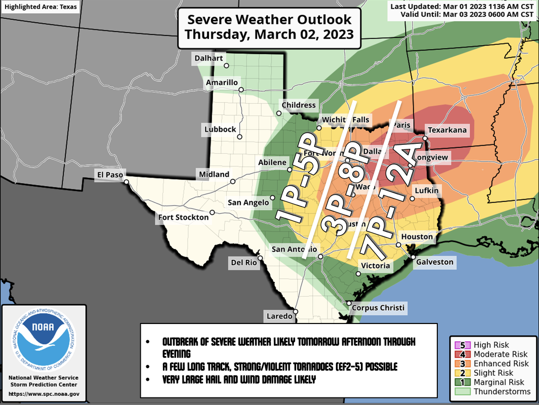 While looking at this map, I always implore people to not get hung up on the exact placement of these colors and lines. Storms inevitably do not follow these maps. They are used to give a general idea of where most of the severe weather is anticipated to happen.
TIMING - In the early morning hours, there will probably be some strong to marginally severe thunderstorms to the south and east of the DFW metroplex. Most of it should be gone by late morning. Everyone in the North-Central Texas region has the potential of seeing severe weather from a broad window of 12pm to 12am tomorrow. However, the core threat for the metroplex will come tomorrow afternoon around the time when most school districts end for the day. The main event for east of the metroplex will come later in the evening after the sun goes down. THREATS - All modes of severe weather will be possible. Very large hail (2" in diameter or greater), wind damage, and several tornadoes are all possible. There might even be a few strong/violent (EF2-EF5) long-track tornadoes tomorrow evening. RAIN - Amounts of 1-2" of rain are likely, and some isolated flash flooding issues are possible. GET READY NOW - Here are some important notes about preparing for tomorrow.
DO NOT BE ANXIOUS OR WORRIED! Events like this are very common in North Texas during our regular tornado season, which includes March, April, and May. Have a way of hearing warnings, have an emergency plan, and you will be fine. Although the odds of any one spot getting a tornado are very low, we must be prepared nonetheless. BE INFORMED: I know I have many first-time readers here. So I would like to say welcome and thank you for taking the time to read my products! I will have many more as we get closer to this event. If you would like frequent weather updates from me, please follow my Twitter @donowx. Please also like our Facebook page linked here. Also, please join our text messaging system to receive daily forecasts and updates by texting @apexstorm to '81010'. Or click the link. THE NORTH TEXAS SEVERE WEATHER THREAT TODAY - A potent storm system from the west is likely to spawn a multi-day severe weather outbreak across much of north and central Texas, continuing into the Deep South through parts of Louisiana, Mississippi, and Alabama tomorrow. The SPC (Storm Prediction Center) has increased the risk of severe storms for much of North Texas to an "enhanced" risk (level 3 of 5), bearing in mind that if confidence increases for long-tracked supercells, an upgrade to "moderate" risk (level 4 of 5) may be issued for areas to the south and east of the metroplex, particularly in central/south-central Texas.  As I always say when I post the severe weather outlook, please do not get too caught up on the exact placement of these colors and zones. The storms ultimately do not know where the exact placement of these colors and will not behave as such. Just know that ALL of the region has a chance of seeing significant severe weather this afternoon and evening. TIMING - Storms could develop in North Texas as early as 2pm. The best chance of significant severe weather for this area will be from 3p to 9p today. This includes ALL of the metroplex. THREATS - ALL modes of severe weather will be possible. This will includes VERY large to perhaps GIANT sized hail in some instances, damaging wind gusts, and the possibility of several tornadoes. In fact, today is one of those days where a strong tornado or two (EF-2 or higher) is not out of the question. Due to the increased amount of rain and moisture in the atmosphere today, any tornado that forms may quickly become rain-wrapped and difficult to see. Do not wait to see or hear a tornado today. If a tornado warning is issued for your area, take cover immediately. WIND - Gradient winds (not pertinent to severe storms) could get as high as 40 mph today. A Wind Advisory is in effect for the metroplex and points to the east until 7pm.  RAIN - About 1.5 - 2" is possible for the metroplex throughout the day, with higher amounts of 2-3" possible for places around Hunt County and points to the northeast. Although a widespread flash flooding event is not anticipated, localized flooding is a possibility.
BE PREPARED, NOT SCARED - Make sure you have a reliable way of receiving warnings this afternoon and evening. DO NOT RELY ON AN OUTDOOR WARNING SIREN. A NOAA Weather Radio should be in every home, and is something that you can easily find at any major retailer. On your phone, make sure you have WEA Alerts enabled. You can join our weather remind by texting @apexstorm to '81010', where we will be sending out updates if a warning gets issued for the metroplex or any of the coverage area. Know the safest place to go in your home, work, or school, and ensure that safe place has helmets for everyone. If you live in a mobile home, you can not stay there during a tornado. Know a site built structure you can evacuate to (business, community shelter, convenience store, etc.) at a moments notice. DO NOT BE ANXIOUS OR WORRIED! Events like this are very common in North Texas during our regular tornado season, which includes March, April, and May. Have a way of hearing warnings, have an emergency plan, and you will be fine. Although the odds of any one spot getting a tornado are very low, we must be prepared nonetheless. BE INFORMED: I know I have many first-time readers here. So I would like to say welcome and thank you for taking the time to read my products! I will have many more as we get closer to this event. If you would like frequent weather updates from me, please follow my Twitter @donowx. Please also like our Facebook page linked here. Also, please join our text messaging system to receive daily forecasts and updates by texting @apexstorm to '81010'. Or click the link. Current surface observations show that the cold front has already moved through the metroplex. As previously mentioned in yesterday's blog entry, this is about 1-3 hours ahead of what the mid-range mesoscale models were showing. Gusty winds and a wind shift to the north can be expected throughout the day, in addition to plunging temperatures before the winter storms' onset.  MAJOR WINTER STORM TO IMPACT THE REGION - As advertised for the past few days, a significant winter storm bringing copious amounts of ice, sleet, and snow is making its' way toward the North Texas region as we speak. *A Winter Storm Warning is in place for ALL of the North Texas region. *The Winter Storm Warning in place for the I-20/287 corridor to the north west of the metroplex goes into effect at 3p today. *The Winter Storm Warning which includes the DFW Metroplex, points to the northeast, and southwest goes into effect at 6p today. *The Winter Storm Warning which includes all areas to the south of the aforementioned municipalities goes into effect at midnight. 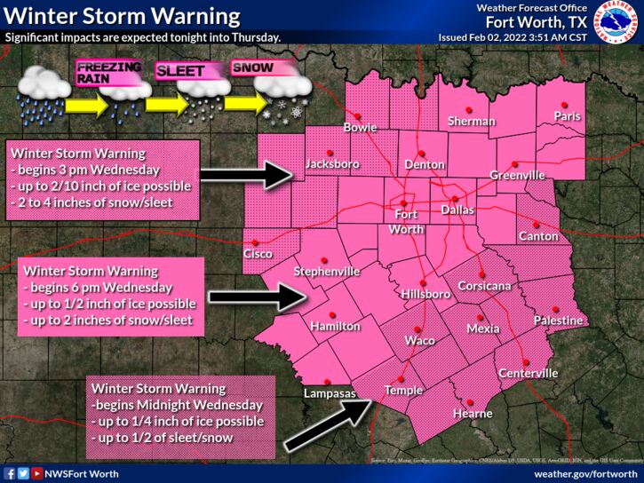 FORECAST UPDATES - As previously mentioned, the cold front is already has already moved through the metroplex, which is a couple of hours ahead of the middle range forecast guidance. This will lead to a higher-end winter weather event. As such, I must adjust the accumulation forecast and timing to compensate for this change.
EARLY WEDNESDAY AFTERNOON - I now expect freezing rain and/or sleet to begin in Montague, Young, and Jack counties as early as 10-11a this morning. For the rest of us, temperatures will continue to fall throughout the day as moderate to heavy rain approaches from the west and south. WEDNESDAY EVENING INTO OVERNIGHT - As moderate to heavy rain falls, expect any pre-existing winter road treatment to dilute or get washed away. I expect most of the metroplex to fall below freezing at around 9-10p tonight. However, because of the fast approach of the front, please do note that there is potential for that to happen potentially in the 8-9p timeframe. All rain will transition to freezing rain when temperatures fall below freezing. From there, a freezing rain/sleet mix can be expected during the overnight hours for much of the metroplex. THURSDAY - While heavy freezing rain and sleet is happening for much of the metroplex at around 3:00a, heavy snow will be approaching from the west, moving to the east. Heavy snow will arrive in the western side of the metroplex at around 4:00a, making it to places such as Denton at around 5:00a. As the system continues to move to the east, I expect a full transition from mostly freezing rain/sleet to moderate to heavy snow for most of the metroplex by 10am, lasting for a few hours. All winter precipitation should be out of the region by late afternoon. ICE ACCUMULATION - A significant ice storm will take place tonight for most of the region, including the metroplex. The northwestern counties will see tad lower ice accumulations than previously forecast due to colder air coming faster than forecast. Most communities to the north of I-20 will see 0.25"-0.5" or greater of ice accumulation. This will make travel extremely difficult for most of the area, including making some roads impossible to travel on. In addition, some power outages and tree damage is likely. SLEET/SNOW ACCUMULATION - Snow will begin in the NW parts of the region, slowing moving east towards the metroplex beginning early Thursday morning, lasting through late Thursday afternoon. For the immediate metroplex, I expect 1-3 inches of sleet/snow accumulation. For those to the NW of the metroplex, higher totals of 2-4" can be expected. TEMPERATURES - Temperatures will fall into the single digits/teens Thursday through Saturday mornings. In addition, temperatures will NOT reach above freezing until Saturday afternoon. Aside from that, Thursday will feature temperatures only reaching the teens into the lower 20s. However, it will feel much colder with a brisk north wind of 15-20mph, gusting to 25mph at times. Wind chills will only reach the single digits throughout the day on Thursday. Many locations will report sub-zero or below temperatures by Friday morning. The actual air temperature will remain in the low 20s throughout the day on Friday. Almost all locations in the metroplex will report below zero wind chills Saturday morning, and most locations will NOT reach above freezing Saturday. Slow melting may occur on Sunday, as temperatures reach sub-freezing by the afternoon. IMPACTS - Please keep in mind that these amounts mentioned in this blog entry are significant and is more than enough to cause disruptions to infrastructure, as well as causing difficult to near impossible travel conditions with some roadways being impossible to travel on. Power outages are likely where ice buildup is on trees and powerlines. Additionally, dangerously cold temperatures are expected in wake of the winter storm for the proceeding days. Appropriate action must be taken to mitigate frostbite and hypothermia. PREPARATIONS SHOULD BE RUSH TO COMPLETION THIS MORNING AND EARLY AFTERNOON. *Be sure all of your phones, tablets, and other devices are fully charged. *Travel is highly discouraged Thursday, Friday, and maybe even Saturday morning. If you MUST travel, create an emergency supply kit for your car. Include jumper cables, sand, a flashlight, warm clothes, blankets, bottled water and non-perishable snacks. Keep a full tank of gas. Have cat litter or sand to help tires get traction, or road salt to melt ice. *Gather supplies in case you need to stay home for several days without power. Keep in mind each person’s specific needs, including medication. Remember the needs of your pets. Have extra batteries for radios and flashlights. *Turn your refrigerator and freezer to their coldest settings. *If you lose power and you plug a generator into the house electrical system, turn the main off in the breaker box. Otherwise it can be very dangerous for the crews working to restore power. *Understand some could be without power for more than 24 hours with very cold, sub-freezing temperatures. Have an alternative source of heat. And, use it safely. WILL THIS BE LIKE FEBRUARY 2021? - That is a bad question. The answer is no. What happened on February 2021 was a generational winter event affect all of Texas, with the coldest temperatures observed in literal decades. We only have storms like that once every 30-40 years. What I will say is that the IMPACTS will be much higher than last year due to having more ice on roadways, power lines, and trees. Power outages may occur from downed trees and power lines from ice, not from high power demand. BE INFORMED: I know I have many first-time readers here. So I would like to say welcome and thank you for taking the time to read my products! I will have many more as we get closer to this event. If you would like frequent weather updates from me, please follow my Twitter @donowx. Please also like our Facebook page linked here. Also, please join our text messaging system to receive daily forecasts and updates by texting @apexstorm to '81010'. Or click the link. Thank you, Donovan Neal Owner - ApexStorm CLOUDY DAY - We begin the day with mostly cloudy skies region wide with temperatures in the low to mid 50s with some isolated cooler spots.  Expect temperatures to be in the middle to upper 60s this afternoon under a mostly cloudy sky. WINTER STORM EXPECTED WEDNESDAY EVENING INTO THURSDAY - A potent arctic cold front combined with a deep upper air trough will bring a winter storm across the central two thirds of the CONUS and much of the North Texas region. This will come in the form of freezing rain, sleet, and even snow. Our best chances of this will be Wednesday evening into Thursday afternoon. DISCLAIMER - THIS FORECAST CAN AND WILL CHANGE WITHIN THE NEXT 24-48 HOURS. I HIGHLY URGE ALL OF YOU TO ONLY USE THE MOST RELEVANT AND FRESH INFORMATION AVAILABLE. IF YOU ARE READING INFORMATION THAT IS AT LEAST HALF A DAY OLD, YOU ARE WORKING WITH BAD INFORMATION. TODAY WILL BE THE LAST GOOD DAY TO PREPARE BEFORE THE INITIAL ONSET OF THE UPCOMING WINTER STORM. WEDNESDAY MORNING AND AFTERNOON - Under a mostly cloudy sky, temperatures will be in the middle to upper 50s in the morning. Upon the arrival of the arctic cold front, temperatures in the metroplex will slowly begin to fall at around lunchtime. In addition, scattered to increasingly widespread showers and thunderstorms will increase throughout the afternoon. The highest chance of heavy rain will be along the I-35 corridor and points to the east. QPF totals will range from 0.5"-1". This will allow any pre-existing winter road treatment to dilute as we progress through the afternoon and evening. WEDNESDAY EVENING INTO EARLY THURSDAY MORNING - Conditions will rapidly deteriorate once temperatures reach below freezing, which will happen from northwest to southeast during the evening. Global models hold off temperatures reaching below freezing until midnight. However, due to the warm bias of these outputs, I fully expect the metroplex to be below freezing by 7 or 8pm. Keep in mind that the arrival of freezing temperatures may arrive earlier or later than the given time by an hour. All rain will transition to freezing rain once temperatures reach below freezing, thus beginning ice accumulation. Then, freezing rain will transition into sleet shortly after the onset of freezing rain. The freezing rain/sleet mix will last all through the night into the morning hours on Thursday. THURSDAY - A wintery mix of sleet and freezing rain will be ongoing for most of the metroplex during the predawn hours. A transition to moderate to heavy snow is likely from west to east, starting at around 8am, lasting for a few hours. Wintery precipitation will diminish through the late afternoon as the trough rotates out of the area, though flurries will still be possible. DANGEROUSLY COLD TEMPERATURES EXPECTED - Below freezing temperatures is expected for the entire metroplex tomorrow evening, lasting through Saturday. That means any precipitation that falls will freeze and remain frozen until we get above freezing for an extended period of time. Aside from that, Thursday will feature temperatures only reaching the teens into the lower 20s. However, it will feel much colder with a brisk north wind of 15-20mph, gusting to 25mph at times. Wind chills will only reach the single digits throughout the day on Thursday. Many locations will report sub-zero or below temperatures by Friday morning. The actual air temperature will remain in the low 20s throughout the day on Friday. Almost all locations in the metroplex will report below zero wind chills Saturday morning, and most locations will NOT reach above freezing Saturday. Slow melting may occur on Sunday, as temperatures reach sub-freezing by the afternoon. IMPACTS - Current thinking is that this will be mainly a freezing rain/sleet event across the metroplex. Areas to the northwest and the metroplex will see 0.5"-1.0" of freezing rain. The highest sleet accumulations will be from the metroplex and northwest, ranging from 0.75" - 1.50" with the possibility of thundersleet. The highest coverage of snow will be in the metroplex and points to the north and weset, where 1-3" will be possible. For DFW, anywhere from a dusting to up to two inches can be expected. Please keep in mind that these amounts are significant and is more than enough to cause disruptions to infrastructure, as well as causing difficult travel conditions with some roadways being impossible to travel on. Power outages are likely where ice buildup is on trees and powerlines. Additionally, dangerously cold temperatures are expected in wake of the winter storm for the proceeding days. Appropriate action must be taken to mitigate frostbite and hypothermia. I fully expect a Winter Storm Warning to be issued for most of North Texas later tonight or sometime tomorrow. PREPARE - Use today to prepare as much as you can around the house... TODAY IS THE LAST GOOD DAY TO PREPARE FOR THIS EVENT. *Be sure all of your phones, tablets, and other devices are fully charged. *Travel is highly discouraged Thursday, Friday, and maybe even Saturday. If you MUST travel, create an emergency supply kit for your car. Include jumper cables, sand, a flashlight, warm clothes, blankets, bottled water and non-perishable snacks. Keep a full tank of gas. Have cat litter or sand to help tires get traction, or road salt to melt ice. *Gather supplies in case you need to stay home for several days without power. Keep in mind each person’s specific needs, including medication. Remember the needs of your pets. Have extra batteries for radios and flashlights. *Turn your refrigerator and freezer to their coldest settings. *If you lose power and you plug a generator into the house electrical system, turn the main off in the breaker box. Otherwise it can be very dangerous for the crews working to restore power. *Understand some could be without power for more than 24 hours with very cold, sub-freezing temperatures. Have an alternative source of heat. And, use it safely. CRAP APPS: All throughout the day yesterday, I have received literally several notes and comments from my professors and colleagues telling me what their weather app is showing. Look, I understand the convenience of the app that is preinstalled on most smartphones. It is insanely convenient! you open it, you are shown a symbol with the high temperature, a low temperature, and a chance of precipitation. In a complex, active winter pattern such as this one, automated apps and websites are pretty much useless 2-3 days in advance (sometimes 24 hours). They use computer model data which can be absolutely horribly inaccurate in a time like this. They do not provide ANY context, and, most importantly, does not communicate uncertainty at all when forecasting. There is going to be range of possibilities and it takes a little more than a glance at an app on a phone to understand the complex weather pattern that we are in. So, I would use great caution while you are looking at an app, and I will leave it at that. :-) MAP LITERACY - Just about anytime we forecast extreme weather, I get dozens of messages that consist of "what about *insert town or city here*". Most of these messages come on posts with references to counties or major highways in North Texas. In my five years of doing this, I have learned that several people struggle with geography, and more specifically have a tough time trying to read maps. I understand. I struggle with many things to. If you were to give me analytic geometry questions, I would look at you like you just shot a man before my eyes. But there is no way we can name hundreds of municipalities in North Texas on every post. I encourage you to take a few minutes to learn the major highways and counties relative to your location. I promise it will help you understand the blog entries and the posts I make here addressing any time of weather extreme.  BE INFORMED: I know I have many first-time readers here. So I would like to say welcome and thank you for taking the time to read my products! I will have many more as we get closer to this event. If you would like frequent weather updates from me, please follow my Twitter @donowx. Please also like our Facebook page linked here. Also, please join our text messaging system to receive daily forecasts and updates by texting @apexstorm to '81010'. Or click the link.
Thank you, Donovan Neal Owner - ApexStorm SEVERE CLEAR THIS MORNING: Most communities feature mostly sunny skies this morning with temperatures in the in the upper 40s to low 50s. Expect a gradual increase in cloud cover throughout the afternoon and evening with day time highs in the middle 60s. There is a chance of showers and thunderstorms this afternoon, mostly for the areas to the south of the I-35 E/W Junction in Hillsboro.  Clouds will remain in place for most of the region on Tuesday, yet, the afternoon will be a few degrees warmer than today with highs in the upper 60s. *POTENTIAL* WINTER STORM POSSIBLE WEDNESDAY EVENING INTO TUESDAY - A potent arctic cold front will bring the possibility of winter weather for much of the central two-thirds of the country in the form of freezing rain, sleet, and snow. Our chances of the aforementioned threats will come from Wednesday evening into Thursday during the day. DISCLAIMER - THIS FORECAST CAN AND WILL CHANGE WITHIN THE NEXT 48-72 HOURS. I HIGHLY URGE ALL OF YOU TO ONLY USE THE MOST RELEVANT AND FRESH INFORMATION AVAILABLE. IF YOU ARE READING INFORMATION THAT IS AT LEAST HALF A DAY OLD, YOU ARE WORKING WITH BAD INFORMATION. TODAY AND TOMORROW WILL BE THE LAST GOOD DAYS TO PREPARE BEFORE THE INITIAL ONSET OF THE UPCOMING WINTER STORM. WEDNESDAY AFTERNOON - Expect the arctic front to slowly arrive into North Texas throughout the afternoon. Conditions will begin to slowly deteriorate upon the arrival of the cold front. A thicker layer of clouds will arrive behind the front. Winds will change directions to the north, in addition to the increase of widespread rain and falling temperatures. WEDNESDAY EVENING (close to when the sun goes down) - Temperatures *may begin to fall below freezing first for the communities to the northwest of the metroplex at around the 4-5p hour, gradually trickling into the urban population through sunset. Though the onset of freezing temperatures won't begin until the sun goes down, the brisk north winds of 20-25 mph will help to expel heat from surface objects, as well as heat from water droplets before they hit the ground. This will lead to ice accumulation with temperatures just at the freezing threshold. *what makes this forecast so challenging is the exact timing of the freezing temperatures. A faster progression of freezing temperatures will result in a more significant winter storm, while a slower progression will lead to minor impacts. For now, the general consensus is sub-freezing to below freezing temperatures by Wednesday night, lasting through Saturday morning. THURSDAY MORNING (pre-dawn hours) - A transition to freezing rain will occur in the metroplex at around midnight, and for those to the south closer to 1-3pm. The subsequent transition to sleet will occur shortly after the onset of the freezing rain (within an hour or two). As temperatures fall below the upper 20s, freezing rain becomes less likely, and sleet will become the dominant precipitation type Thursday morning. Those to the northwest of the metroplex can expect a full transition to snow an hour or two before 'sunrise'. THE REST OF THURSDAY - Winter precipitation will continue through Thursday morning and afternoon, mostly in the form of sleet in the metroplex, tapering off by the evening as the upper level trough moves eastward. IMPACTS - Current thinking is that this will be a freezing rain/sleet event across the metroplex. Areas to the northwest of the metroplex will see 0.25"-0.5" of freezing rain, while the urban islands will see around 0.25". Remember, all it takes is 0.01" of freezing rain to cause significant issues on roadways. The highest sleet accumulations will be from the metroplex and northwest, ranging from 0.75" - 1.50" with the possibility of thundersleet. The highest coverage of snow will be to the northwest of the metroplex where 1-3" will be possible. For DFW, a dusting to an inch can be expected. Please keep in mind that these amounts are significant and is more than enough to cause disruptions to infrastructure, as well as causing difficult travel conditions with some roadways being impossible to travel on. Power outages are likely where ice buildup is on trees and powerlines. I fully expect a Winter Storm Watch or Ice Storm Watch to be issued for most of North Texas later tonight or sometime tomorrow. MAP LITERACY - Just about anytime we forecast extreme weather, I get dozens of messages that consist of "what about *insert town or city here*". Most of these messages come on posts with references to counties or major highways in North Texas. In my five years of doing this, I have learned that several people struggle with geography, and more specifically have a tough time trying to read maps. I understand. I struggle with many things to. If you were to give me analytic geometry questions, I would look at you like you just shot a man before my eyes. But there is no way we can name hundreds of municipalities in North Texas on every post. I encourage you to take a few minutes to learn the major highways and counties relative to your location. I promise it will help you understand the blog entries and the posts I make here addressing any time of weather extreme.
FRIGID DAYS TO COME - With the arrival of the cold front, temperatures will not climb above freezing until Saturday afternoon at the absolute earliest. That means, anything that is on the ground will remain frozen. Dangerously cold temperatures will come Friday and Saturday morning with overnight lows reaching the single digits to the teens, with wind chills in the single digits.
PREPARE - Use today tomorrow to prepare as much as you can around the house... *Be sure all of your phones, tablets, and other devices are fully charged. *Travel is highly discouraged Thursday. If you MUST travel, create an emergency supply kit for your car. Include jumper cables, sand, a flashlight, warm clothes, blankets, bottled water and non-perishable snacks. Keep a full tank of gas. Have cat litter or sand to help tires get traction, or road salt to melt ice. *Gather supplies in case you need to stay home for several days without power. Keep in mind each person’s specific needs, including medication. Remember the needs of your pets. Have extra batteries for radios and flashlights. *Turn your refrigerator and freezer to their coldest settings. *If you lose power and you plug a generator into the house electrical system, turn the main off in the breaker box. Otherwise it can be very dangerous for the crews working to restore power. *Understand some could be without power for more than 24 hours with very cold, sub-freezing temperatures. Have an alternative source of heat. And, use it safely. CRAP APPS: Just from this morning, I have received literally several notes and comments from my professors and colleagues telling me what their weather app is showing. Look, I understand the convenience of the app that is preinstalled on most smartphones. It is insanely convenient! you open it, you are shown a symbol with the high temperature, a low temperature, and a chance of precipitation. In a complex, active winter pattern such as this one, automated apps and websites are pretty much useless 2-3 days in advance (sometimes 24 hours). They use computer model data which can be absolutely horribly inaccurate in a time like this. They do not provide ANY context, and, most importantly, does not communicate uncertainty at all when forecasting. There is going to be range of possibilities and it takes a little more than a glance at an app on a phone to understand the complex weather pattern that we are in. So, I would use great caution while you are looking at an app, and I will leave it at that. :-) BE INFORMED: I know I have many first-time readers here. So I would like to say welcome and thank you for taking the time to read my products! I will have many more as we get closer to this event. If you would like frequent weather updates from me, please follow my Twitter @donowx. Please also like our Facebook page linked here. Also, please join our text messaging system to receive daily forecasts and updates by texting @apexstorm to '81010'. Or click the link. Thank you, Donovan Neal Owner - ApexStorm VERY ACTIVE AFTERNOON - You will want to pay special attention to the weather afternoon as we have the threat of all modes of severe storms this late afternoon into tonight. MIDDAY LULL - As forecast, most of the morning clouds have cleared the region, leaving us with a mostly sunny sky. With the sunshine, temperatures are rising to the middle 80s, making for a very unstable atmosphere. Some places could easily reach the low 90s this late afternoon, which is ten degrees above our average high for this time of the year. It will feel more like an humid, early summer day this afternoon. "SURPRISE" SEVERE WEATHER RISK THIS EVENING - Since the cold front decided it wanted to arrive six hours later than previously forecast, we now have a volatile airmass for severe storms to initiate in. As dynamic support increases, we will have a threat of severe weather through tonight. PLACEMENT - The Storm Prediction Center has defined an "enhanced risk" (level 3/5) of severe weather for all of the immediate metroplex which includes areas along and to the north of US-67 between Johnson and Ellis counties, with the standard "slight risk" (level 2/5) for the rest of the region. The highest tornado probabilities exist within the enhanced risk zone, and a strong/violent tornado is not out of the question here. 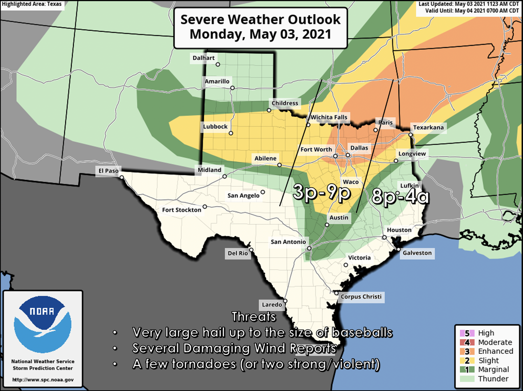 TIMING: I expect storm initiation to take place somewhere to the west of the metroplex at around 3p this afternoon. The main threat of severe weather for most of the population will come at around 6-9p with the threat for our eastern counties at around 8p, lasting through the pre-dawn hours Tuesday morning. THREATS - All modes of severe weather are possible, mainly including the threat for very large hail and the possibility of a few tornadoes. Based on the volatile airmass, there could be one or two strong/violent tornadoes (EF2-EF5). In addition, wind damage will also be a concern as well. CALL TO ACTION - Today is day where you and your family need to keep ready for severe thunderstorms. Be sure you have multiple ways of receiving warnings. NEVER RELY ON A TORNADO SIREN. First, make sure you have a NOAA Weather Radio. Every home in North Texas needs one as they work off of their own network, making them very reliable. On your phone, make sure you have WEA (Wireless Emergency Alerts) enabled on your phone. To make sure of this go to Settings > Notifications > scroll all the way down to the bottom to ensure that "Emergency Alerts" are enabled. Find the safest place in your home. It is typically in a small room, on the lowest floor, near the center of your house, away from windows. In that safe place, have helmets for everyone, airhorns (in case you are injured and need to alert first responders on site), and hard-sole shoes (if you must walk over tornado debris). If you live in a mobile home, you can not stay put during a tornado warning. Identify the nearest location of a shelter or safe place, and know how to get there at a moments notice. TUESDAY THROUGH FRIDAY - Lingering showers and storms should end early in the day on Tuesday, followed by clearing as drier air returns. The weather should remain dry for most of the region with highs in the upper 70s to low 80s. THE WEEKEND - Both days should feature a good supply of sunshine with a high between 85-90. Southerly winds will increase on Saturday. NEXT WEEK - A stalled surface front will keep at least a slight chance of showers and thunderstorms in the forecast through early next week with seasonably warm temperatures for early May... see the Texas Weather Discussion Video for more details. 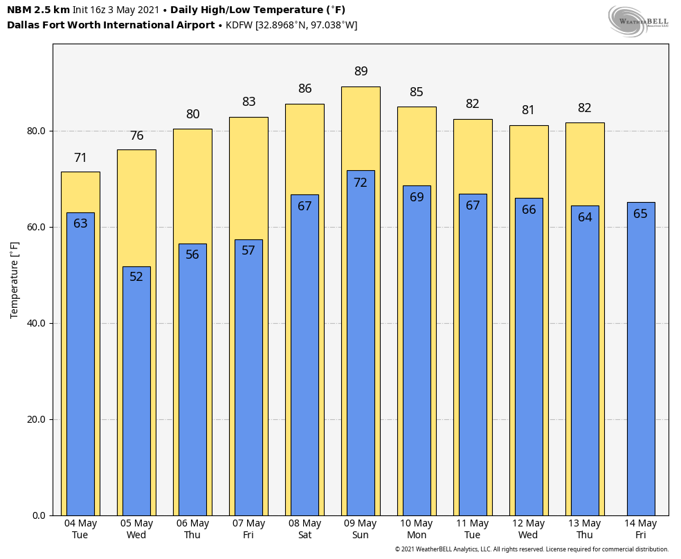 ON THIS DATE IN 1999 - There were 63 tornadoes in Oklahoma, making this the worst outbreak ever to strike the state. In Central Oklahoma alone, eight individual supercell thunderstorms produced 57 tornadoes. Bridge Creek, Moore and southern parts of the Oklahoma City Metro area were hit the hardest. When it was near Moore, Oklahoma, a truck-mounted Doppler radar measured a wind speed of 318 mph, the highest ever observed in a tornado. Forecasters at the Storm Prediction Center in Norman, OK were faced with the unprecedented situation of a major tornado on the ground threatening their location. As a major F5 tornado was approaching the Oklahoma City metro area from the southwest, the SPC notified its backup, the Air Force Weather Agency at Offutt AFB in Omaha, Nebraska that they might have to assume operational responsibility if the tornado approached Norman. The storm remained several miles west of the facility but was visible from the SPC roof. Damage from this single tornado was around one billion dollars, making it the most costly tornado in history.
RECORD COLD MORNING - For many communities outside of the metroplex, temperatures are a touch below freezing, leading to a rare mid-spring freeze across parts of the NTX region and much of the midwest. Here are some of the observed temperatures early this morning... DENTON 33 DFW AIRPORT 40 ARLINGTON 36 GAINSVILLE 32 SHERMAN 32 JACKSBORO 29 MINERAL WELLS 31 GREENWILLE 33 ROCKWALL 36 HILLSBORO 34 To put things in perspective, our average last freeze date is March 12, and our latest last freeze on record is April 13, 1957. We didn't break that record in the metroplex, but we did get really close. We did break our old record low of 39° in the metroplex this morning for April 21. The good news is that we should warm up very nicely this afternoon with a mostly sunny sky with high clouds increasing late in the day. Highs will maintain in the low to mid 60s, just like yesterday. Clouds will stick around for the day tomorrow with some sprinkles at times. Highs will stay in the mid 60s due to cloud cover. SEVERE WEATHER POSSIBLE FRIDAY - A dynamic weather system will bring the possibility of severe storms for much of the south-central Plains and much of the North-Central Texas region Friday afternoon and evening. The Storm Prediction Center continues a large standard "slight" (2/5) risk of severe storms for all of North and Central Texas throughout much of Central Oklahoma. 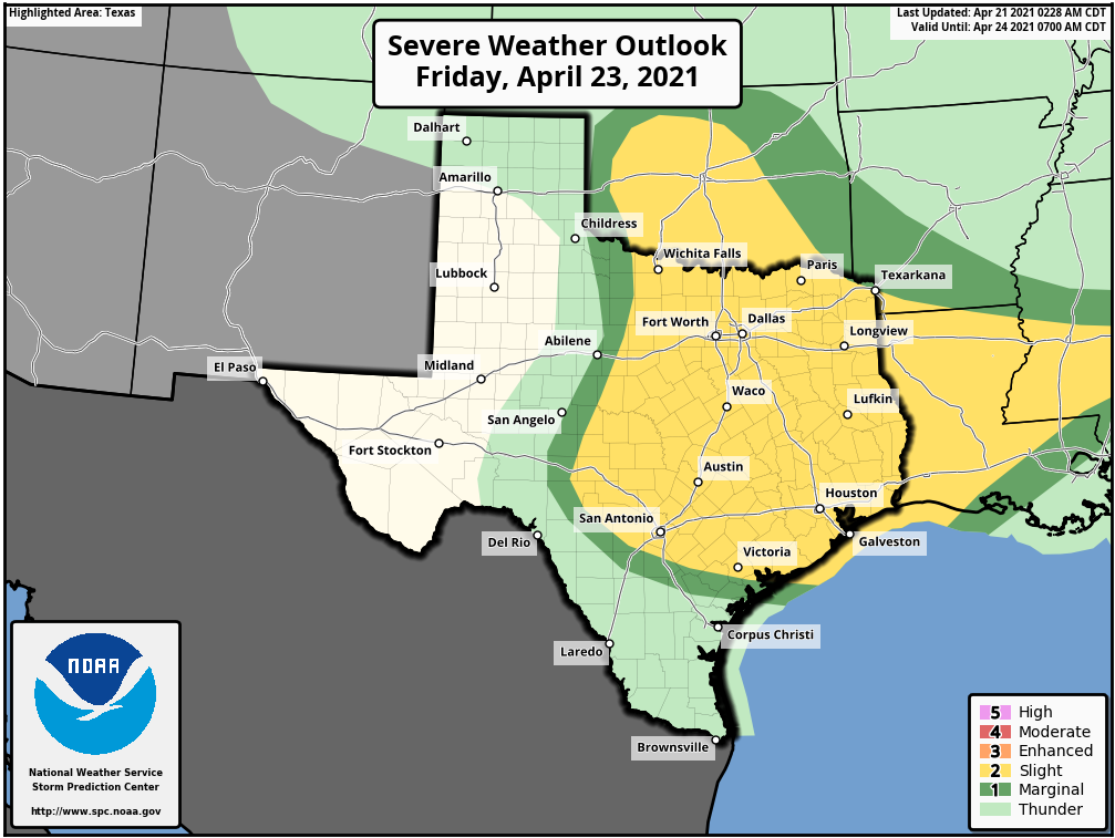 All modes of severe weather appear possible, including the threat for very large hail up to the size of baseballs, in addition to isolated tornadoes. Once we get within 60 hours of the event (that will be later this afternoon and evening) we will get within range of the convection allowing models, and will have a much better idea of the timing and magnitude of the threat. Just know that Friday will be a day where it is imperative that you are weather aware. Dry air returns Saturday morning, and the weekend should be quiet and dry with highs in the upper 70s on Saturday, followed by the low 80s on Friday. NEXT WEEK - Our weather will be very warm and dry on Tuesday... the high Monday will be in the low to mid 80s by the afternoon. A dynamic weather system will spark another chance of severe weather on Tuesday for North-Central Texas through Central Oklahoma. At this time, it appears that all modes of severe weather are possible once again. The SPC has introduced a standard "slight risk" zone for the aforementioned areas, but greater probabilities may be needed if trends continue. See the Texas Weather Discussion Video for more details.  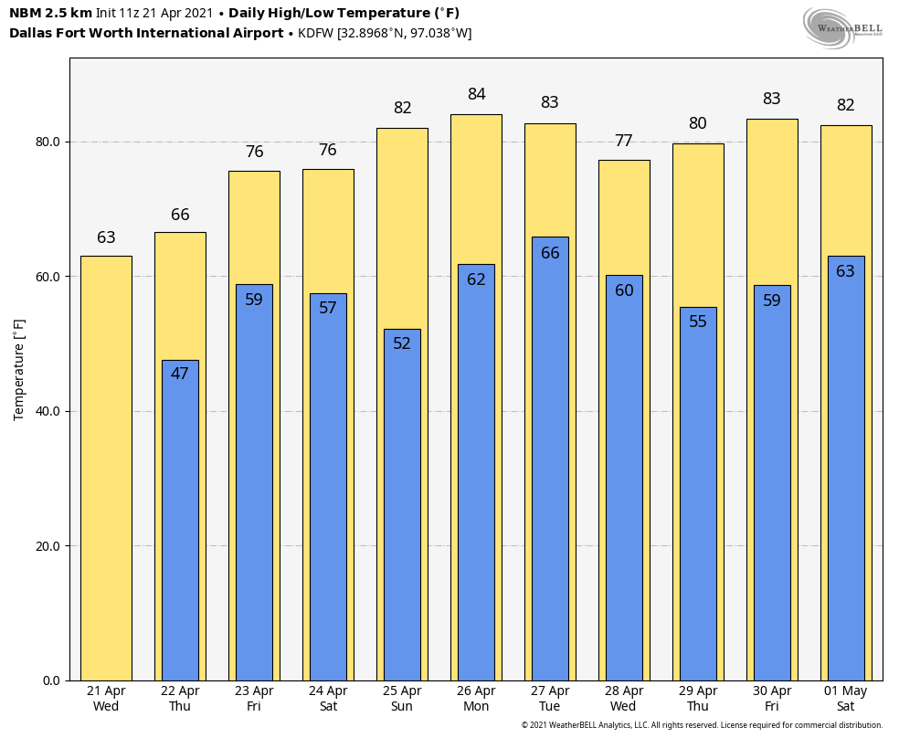 ON THIS DATE IN 1967 - Severe thunderstorms spawned 48 tornadoes in the Upper Midwest. Hardest hit was northern Illinois where sixteen tornadoes touched down during the afternoon and evening hours causing fifty million dollars damage. On that Friday afternoon, tornadoes struck Belvidere IL and the Chicago suburb of Oak Lawn, killing 58 persons.
RADAR CHECK - Another disturbance is currently bringing beneficial rain for a good chunk of the region this mid-morning. 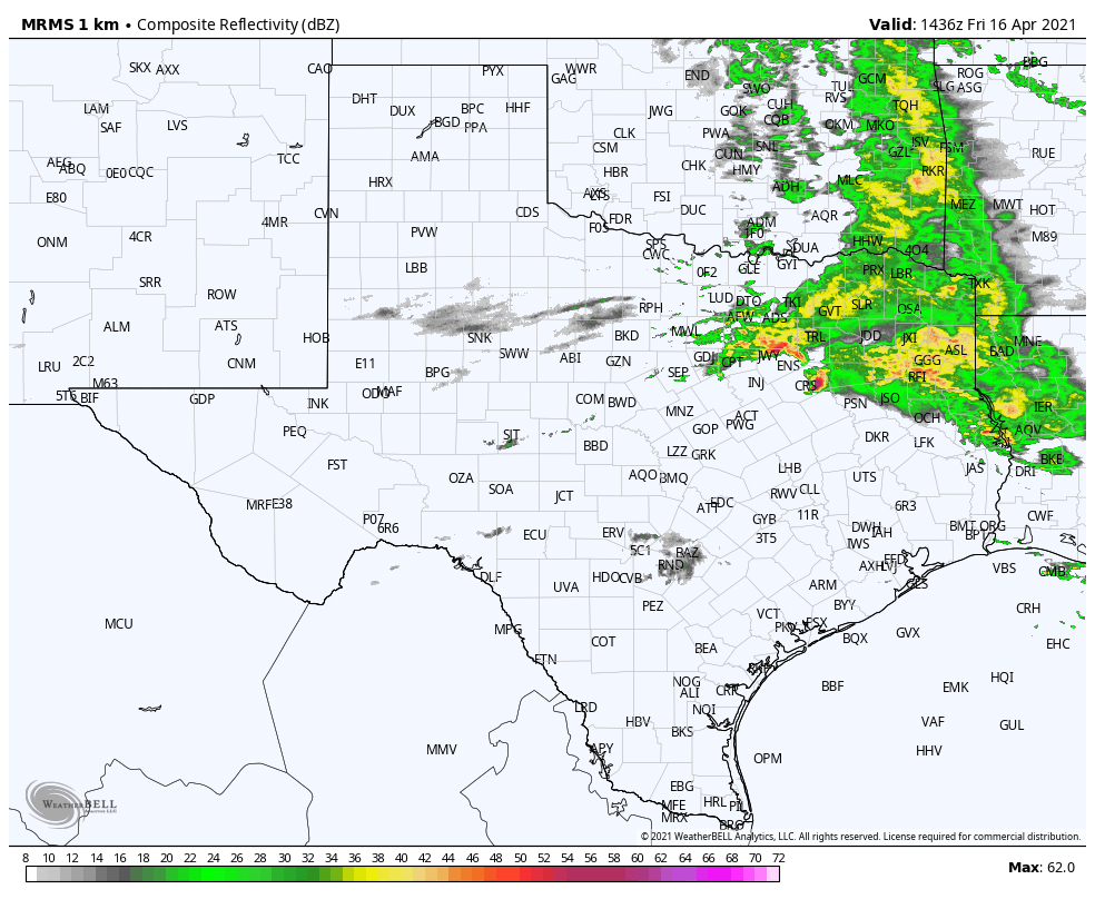 You may hear a few claps of thunder with some of the heavier storms, but all of the storms this morning have remained below severe limits. The SPC is maintaining a low-end "marginal risk" (1/5) of severe thunderstorms for much of the region due to a chance of some of the stronger cells producing hail up to the size of quarters. 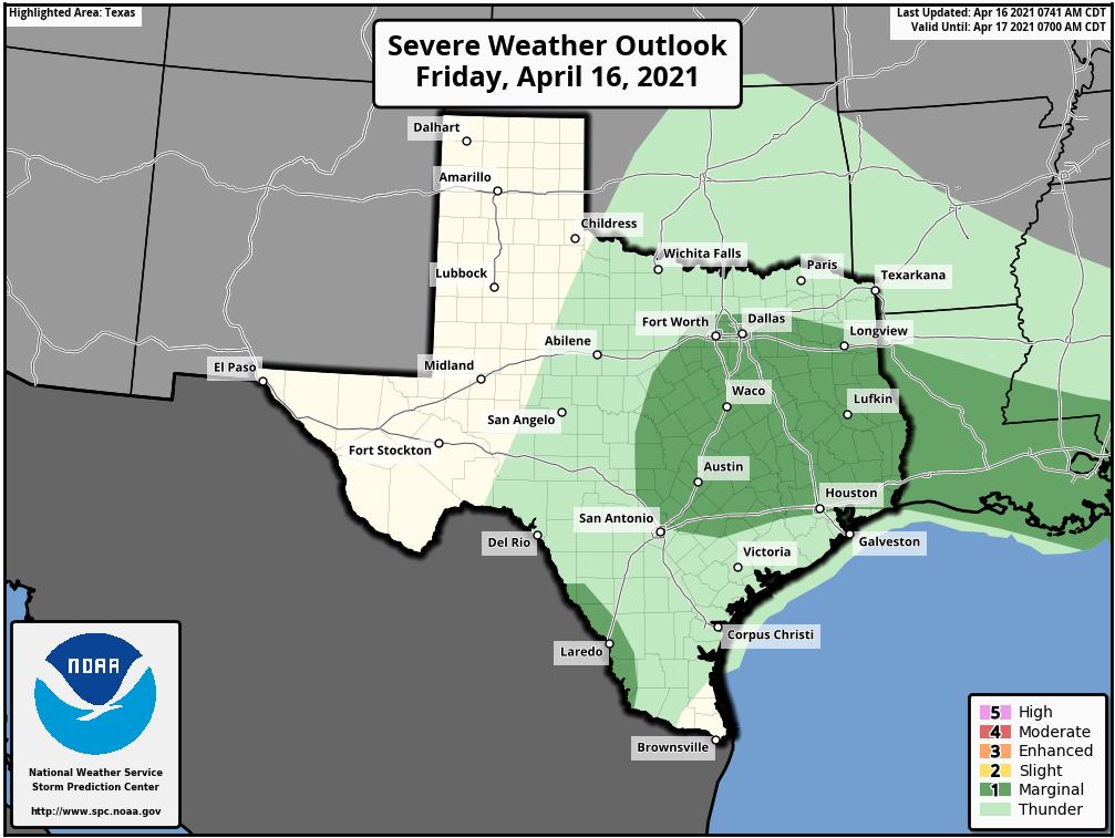 Expect some breaks in the rain by the late morning, and most of the rain should be out of the region by late afternoon with only a few leftovers. I expect a cloudy sky across the state today with temperatures remaining in the low to mid 60s this afternoon, that's about ten degrees below average from our normal high in mid April. THE WEEKEND - I expect a dry weekend ahead as dry air behind the cold front moves through the region. The sky will be mostly cloudy on Saturday (with some periodic breaks) with a chilly breezy northerly wind. Therefore, we are keeping afternoon highs in the low 60s across NTX. Then the sun will appear in sudden fashion with highs warming up to the mid 60s. NEXT WEEK - The weather looks quiet for much of the week. We will begin a gradual warming trend on Monday with highs starting out at around 70° by the afternoon. Monday and Wednesday will feature a sky filled with sunshine, followed by Tuesday and Thursday featuring a mix of sun and clouds. Temperatures will remain seasonably average next week. We will welcome our next chance of rain by Friday afternoon with a shortwave trough positioned near the Arizona/Mexico border. See the Texas Weather Discussion Video for more details. 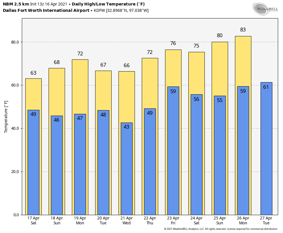 ON THIS DATE IN 2011 - The same system that produced 45 tornadoes in Alabama on April 15, 2011 moved eastward; North Carolina was the hardest hit state. Thirty confirmed tornadoes occurred in North Carolina, the greatest one-day total for North Carolina on record. A total of 24 individuals lost their lives in North Carolina with thirteen tornadoes classified as strong (EF-3 or higher).
RADAR CHECK - Rain continues to fall this afternoon over much of Northwest Texas into West-Central Oklahoma... the rest of the region is dry with a field of clouds. Temperatures are in the upper 70s where some breaks in the clouds have been observed; the northern counties are still in the 60s because of clouds. Scattered rain will increase over North Texas during the midnight hours, and there will be periods of rain through Friday as multiple disturbances past through the region. A few heavier storms with hail up to the size of quarters are likely tomorrow during the day over areas to the south and west of the metroplex, where the SPC has a low end, "marginal risk" (1/5) of severe storms. However, I do not foresee any severe weather issues for most of the region. 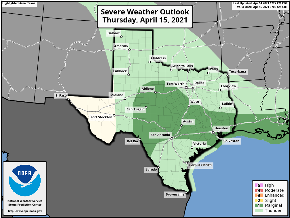 Expect mostly cloudy skies tomorrow through Friday evening with highs staying in the 60s for much of the metroplex. THE WEEKEND - Most communities will be mostly cloudy on Saturday, though lingering showers and thunderstorms during the afternoon is not out of the question. Then, a punch of dry air pushes into the region on Sunday, where we should see most communities enjoying a good supply of sunshine by the afternoon with highs in the mid 60s... about ten degrees below average for mid-April in North Texas. NEXT WEEK - A quiet weather pattern ensues. The weather looks dry Monday through Thursday... some rain could return toward the end of the week on Friday. Temperatures will be near, or, a little below average. See the Texas Weather Discussion Video for more details. 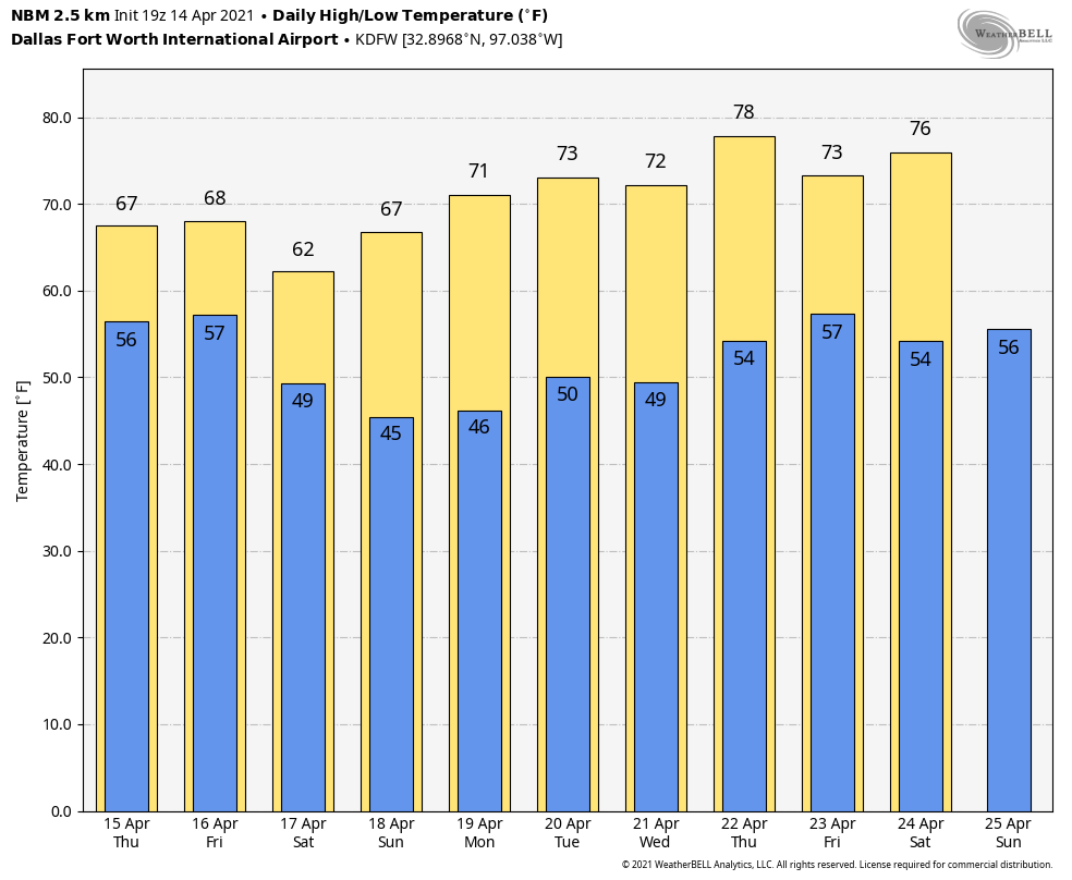 ON THIS DAY IN 1935 - Black Sunday refers to a particularly severe dust storm that occurred on April 14, 1935, as part of the Dust Bowl. During the afternoon, the residents of the Plains States were forced to take cover as a dust storm, or "black blizzard," blew through the region. The storm hit the Oklahoma Panhandle and Northwestern Oklahoma first and moved south for the remainder of the day. It hit Beaver around 4:00 p.m., Boise City around 5:15 p.m., and Amarillo, Texas, at 7:20 p.m. The conditions were the most severe in the Oklahoma and Texas panhandles, but the storm's effects were felt in other surrounding areas.
RADAR CHECK - Isolated thunderstorms are occurring over West Texas, just to the north of Abilene... The rest of the NTX region is dry with a partly sunny sky. Temperatures are in the low 80s to the southeast where the sun is out; DFW remains in the mid 70s due to clouds. Rain and thunderstorms will increase over Oklahoma this evening, and there will be a chance of showers overnight. A few heavier thunderstorms are likely outside of the metroplex, where the SPC continues a low end, "marginal risk" (level 1 of 5) of severe storms. However, there will not be any severe weather issues tonight for most of the region.  The best chance of rain over the eastern half of the state will come during the pre-dawn hours tomorrow. The day will be noticeably cooler tomorrow with highs in the upper 60s in the metroplex. THURSDAY THROUGH THE WEEKEND - Most of Thursday afternoon remains dry with highs in the upper 60s and a partly sunny sky. Then, multiple waves of isolated to scattered showers and thunderstorms are possible Thursday evening through Friday afternoon. As a result, we will forecast a mostly cloudy Friday sky with highs only reaching the mid 60s. We will mention another 1 in 5 chance of showers Saturday morning as another weak disturbance moves through. Most of the metroplex will be dry over the weekend... The sky will feature more clouds than sun on both days with highs between 60 and 65 degrees. NEXT WEEK - The weather remains quiet; generally dry with temperatures around seasonal averages. See the Texas Weather Discussion Video for more details.  ON THIS DAY IN 1987 - Wind gusts up to 98 mph in northern Texas were caused by thunderstorms. At the Killeen Airport, storms caused $1 million in damage. Two planes were destroyed and ten others damaged.
The Texas Weather Discussion Video is a detailed weather discussion that goes far beyond what is normally shown in a traditional TV setting! From Donovan Neal and ApexStorm - Dallas/Fort-Worth. ACTIVE WEATHER AHEAD - A dynamic storm system will bring multiple chances of severe weather from the southern Plains through much of the Deep South this afternoon, evening, and through parts of Saturday morning. The SPC has defined a moderate risk of severe storms (4/5) for the lower Mississippi River Valley, with an Enhanced Risk (3/5) surrounding it. 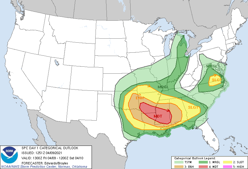 Closer to home, we have the standard "slight" risk (2/5) of severe weather for most of the metroplex, with the enhanced risk in the northeastern corner of the state for this afternoon and evening... 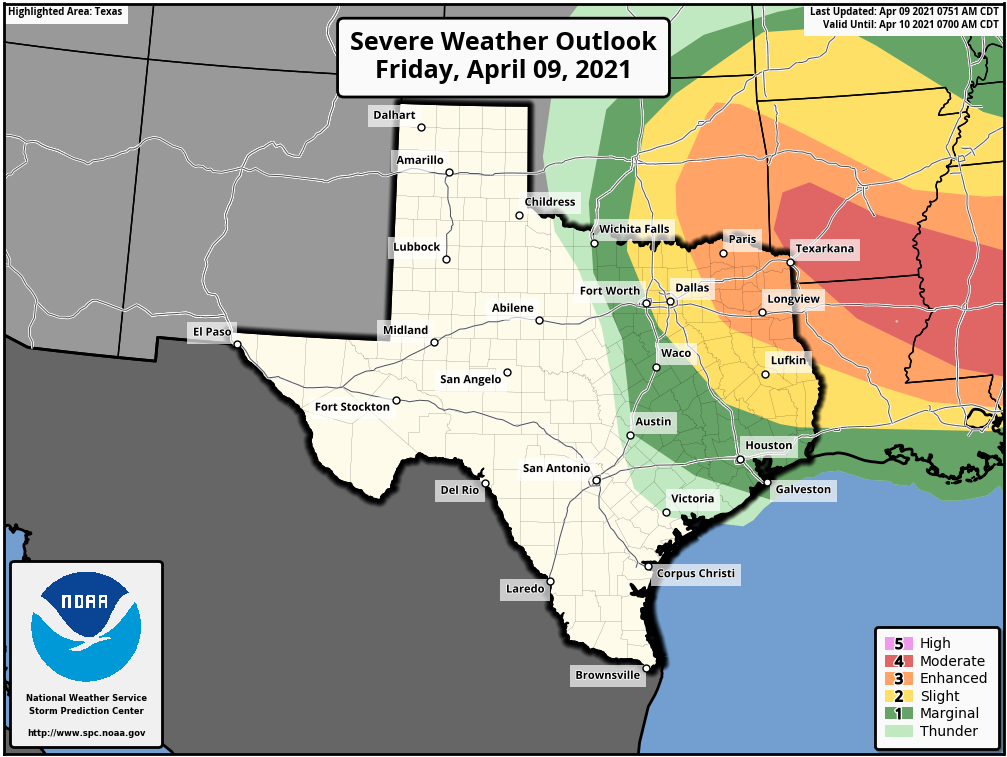 TIMING - Keep in mind that the threat for severe storms today remains very conditional. The cap, which is the warm layer just above the surface, is known for keeping North Texas safe from major severe weather events when they are forecast. If storms had the best chance to break the cap, they would do it from around the 3:00-9:00p hours. THREATS - Any storm that develops will remain isolated. That being said, most places will stay dry this evening. However, said storms would be capable of producing hailstones greater than two inches, and maybe an isolated tornado or two, especially to the east of US 75. RAIN - Rain amounts are expected to stay fairly light, with many locations getting nothing at all, while some places will receive downpours from the isolated storms Just make sure you have a way of getting warnings this afternoon and evening as very large hail will be a concern with any severe thunderstorm that develops in the metroplex during the PM hours. The sky becomes mostly sunny tomorrow as a dry slot moves into the state... the high will be in the mid 70s. SUNDAY AND NEXT WEEK - Sunday and Monday will feature a mix of sun and clouds with dry weather on both days. Highs will stay pretty close to the low 80s with fair nights. A few showers and storms are likely Tuesday through Thursday, with severe weather possible on Friday. See the Texas Weather Discussion Video for maps, graphics, and more details.  ON THIS DATE IN 1947 - An estimated F5 tornado struck Woodward, Oklahoma during the late evening killing 95 persons and causing six million dollars damage. The tornado, one to two miles in width, and traveling at a speed of 50 mph, killed a total of 167 persons along its 221-mile path from Texas into Kansas, injured 980 others, and caused nearly ten million dollars damage.
CONNECT - You can find me on most of the major social networks.... ApexStorm Weather Text Messaging System Be sure to join the text message remind and follow my twitter for weather updates throughout the day... enjoy the weekend! The same principle for winter weather forecasting applies to severe weather forecasting. Before high-end weather events such as this one, it is important that you are reading fresh information. If you are reading products that are 10-12 hours old, you are working with bad information. This blog update was released at 3:54 PM CDT on Tuesday, March 16. DANGEROUS ST. PATRICKS DAY SEVERE WEATHER OUTBREAK TOMORROW - Let me preface this blog entry by saying that this is the most serious threat of severe weather the Deep South has had since April 28, 2014. We saw what transpired in the Texas Panhandle a few days ago and knew that a major severe weather episode was not too far from us. And now, here we are. The Storm Prediction Center (SPC) has a Moderate Risk (4/5) of severe weather for much of Central Alabama, Mississippi, and parts of Louisiana, Arkansas, and Tennessee. The rest of the categorical spectrum follows for the rest of the subsequent areas on the map.  Before I proceed further. I encourage you to not get hung up on the exact placement or names of these risks. Storms do not follow these colorful guidelines and have no idea where they are. It ultimately does not matter whether the SPC issues a High Risk tomorrow. Some red letter severe weather days happen to fall on moderate risk days. The point is that everyone that is in the Enhanced Risk and higher need to pay special attention to the weather over the next 48 hours, and craft a plan for different scenarios.
SYNOPSIS - A negative tilt upper trough with high wind gradients will spin up an upper low over Arkansas. Warm, moist, unstable air will already be covering most of the region. The mid-level jet will become coupled with the low-level jet by the afternoon and evening hours tomorrow, especially after sunset, creating a favorable combination of lift, shear, and helicity for potentially strong tornadoes and very large hail, and damaging winds. The greatest probabilities for a regional episode of tornadoes is forecast in the moderate risk area. Yes, that means there is a threat for strong/violent, long track tornadoes even after dark. In addition to the tornado risk, very large to giant sized (golf ball sized or larger) hail and wind damage will like be likely across a large part of Arkansas, Mississippi, Northern Louisiana, and Western Tennessee tomorrow afternoon and evening.. The threat for damaging winds is expected to increase as a mesoscale convective system (MCS) moves eastward across the entire region Thursday morning, signaling the end of the threat for severe weather by daybreak for Mississippi and Alabama. TIMING - Thunderstorms are likely tomorrow morning for the northern quarter of the aforementioned region along a northerly moving front. Some of those storms could be strong. The severe weather risk associated with that looks very low, however, on days like this, we will have to closely monitor. Afternoon storms will begin to develop to the west by at least 2PM, where they will be scattered in nature. Any storm that develops at this time could quickly turn severe. The peak for discrete supercell thunderstorms for Mississippi and Alabama will come from around 3PM to 3AM. The more organized activity will come well after midnight. THREATS - ALL modes of severe weather will be possible, including the threat for damaging winds and VERY large hail. Several tornadoes are expected, including the possibility for violent long-tracked tornadoes even after dark in many places. UNCERTAINTY - With any severe weather event, comes with the air of uncertainty that could either make for a worse-case scenario or for storms to not be as intense, which is ultimately what we want. Elevated convection within the warm sector is expected during the morning hours, which could dampen the overall severe potential, or produce enough outflow to introduce a higher-end tornado potential. In addition, it is unknown how quick or sharp the cold front will end up being, which can make the difference between several discrete supercells or only a few stronger discrete cells with a lot of clusters in between. This type of uncertainty precludes the need to upgrade to a high risk with this forecast at this present time. However, a High Risk is probable sometime tomorrow due to the potential for a high-end life threatening event across the Deep South. WiLl tHiS bE LiKE aPRiL 27tH, 2011?: I really do not like this question at all. 216 tornadoes were confirmed that day, with a third of them being strong to violent. Those are generational events. Meaning, they tend to happen once every 40 years or more. However, bear in mind that if there is only one tornado in your state, and that happens to come down your street, that is YOUR April 27th, 2011. PREPARE, PREPARE, PREPARE: Today is day where you and your family need to keep ready for severe thunderstorms. Be sure you have multiple ways of receiving warnings. NEVER RELY ON A TORNADO SIREN. First, make sure you have a NOAA Weather Radio. Every home in the Deep South needs one as they work off of their own network, making them very reliable. On your phone, make sure you have WEA (Wireless Emergency Alerts) enabled on your phone. To make sure of this go to Settings > Notifications > scroll all the way down to the bottom to ensure that "Emergency Alerts" are enabled. Find the safest place in your home. It is typically in a small room, on the lowest floor, near the center of your house, away from windows. In that safe place, have helmets for everyone, airhorns (in case you are injured and need to alert first responders on site), and hard-sole shoes (if you must walk over tornado debris). If you live in a mobile home, you can not stay put during a tornado warning. Identify the nearest location of a shelter or safe place, and know how to get there at a moments notice. MAP LITERACY - Just about anytime we forecast extreme weather, we get dozens of messages that consist of "what about *insert town or city here*". Most of these messages come on posts with references to counties or major highways. In my five years of doing this, I have learned that several people struggle with geography, and more specifically have a tough time trying to read maps. I understand. I struggle with many things to. If you were to give me analytic geometry questions, I would look at you like you just shot a man before my eyes. But there is no way we can name hundreds of municipalities on every post. I encourage you to take a few minutes to learn the major highways and counties relative to your location. I promise it will help you understand the blog entries and the posts I make here addressing any time of weather extreme. YOU'RE GONNA BE FINE: I am well aware that we are in a time in our society that most people in the South, and nationwide, are suffering from high anxiety from a global pandemic and civil tensions. The last thing we want as trusted forecasters is to add to that anxiety. However, at the same time, we must present the weather situation the way it currently stands. I understand we have many people across the south who have a literal phobia of thunderstorms and tornadoes. If you are located anywhere in the Deep South, just know that there is no reason to panic about tomorrow. Even during a severe weather outbreak, the chances of a tornado hitting your house are low, as tornadoes are tiny compared to counties, or the entire state. Unfortunately, lots of amateur weather weenies are on the social media outlets today using a myriad of scare tactics, which is ridiculous and irresponsible. They do not have any prior knowledge behind the different models and maps, what they mean, or how to interpret it. Yet, people will share them without second guessing. Please stay away from these pages, as nobody needs more anxiety. Only get weather information from trusted sources (like this blog and our social media outlets). Donovan Neal Owner - ApexStorm TODAY - A warm front is exiting most of Texas this morning. For North Texas, that means skies will remain generally cloudy with isolated to perhaps scattered showers throughout the day, mainly during the afternoon. It will not be a complete washout, but, just keep a close eye on the radar for rain at times. A few rumbles of thunder is possible, but no severe weather issues today. The Storm Prediction Center has removed the marginal risk for parts of North Texas today. Highs will be in the upper 60s to lower 70s. TOMORROW - The old front will exit Texas, and a new, stronger front will begin moving through the region during the morning. Showers will be ongoing for parts of Northeast Texas, eventually spreading to the southeast throughout the day. Most communities will stay dry in the morning, but isolated to scattered showers will increase through the afternoon. Just like Saturday; not a widespread event, but just rain at times. Some storms may produce some thunder, and some of the stronger storms may pose a threat for hail and gusty winds. Highs in the mid to upper 60s. MONDAY - Widespread showers and storms are possible especially during the pre-dawn hours and through most of the afternoon. The cold front will have exited the region by now. Rain will eventually taper off in the evening. No severe weather is expected and afternoon highs will be in the mid 50s due to rain cooled air. TUESDAY - The activity will have finally moved out of the region by early Tuesday morning, which should lead to most of the day being dry, although mostly to partly cloudy. A stray shower or two is never out of the question. Highs will be in the upper 50s/low 60s across the area. WEDNESDAY - The chance of us seeing some sunshine during the day is much greater on Wednesday as we start to dry out now that the shower and thunderstorm activity is out of North Texas. Skies will be mostly sunny with highs in the upper 60s. THURSDAY - A surface low looks to form over the Texas Panhandle during the day that will be moving in our direction throughout the evening. While most of the day will feature a mix of sun and clouds with highs in the upper 60s to low 70s, I can not forget the potential for isolated showers Thursday night and Friday morning as the low rotates through our area. FRIDAY - The low quickly rotates out of our area, and we should be completely dry by daybreak. Another pleasant, spring-like day is expected with highs in the mid to upper 60s across the region.  PROJECTED RAINFALL AMOUNTS - We can expect a decent amount of rainfall over the week ahead as the WPC is projecting anywhere from .5-2" of rain for much of North Texas.
Donovan Neal Owner - ApexStorm Another surge of arctic air is expected over most of the region overnight, which will create the coldest airmass North Texas has seen since 1989, despite us seeing that type of cold this morning. The NBM (National Blend of Models) currently has all of the region at zero degrees, with several places reaching below zero Tuesday morning... 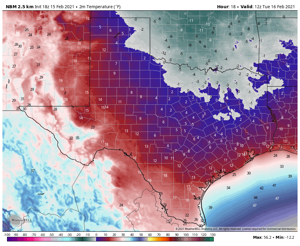 This will allow all of the snow and ice we saw yesterday to continue to stay in place for another day, making travel extremely difficult to nearly impossible throughout the day. I expect the demand to be the same for power across the state, so I don't see any improvements to the power situation across Texas anytime soon. As of 8:08 PM, 4,363,283 Texans are without power right now... 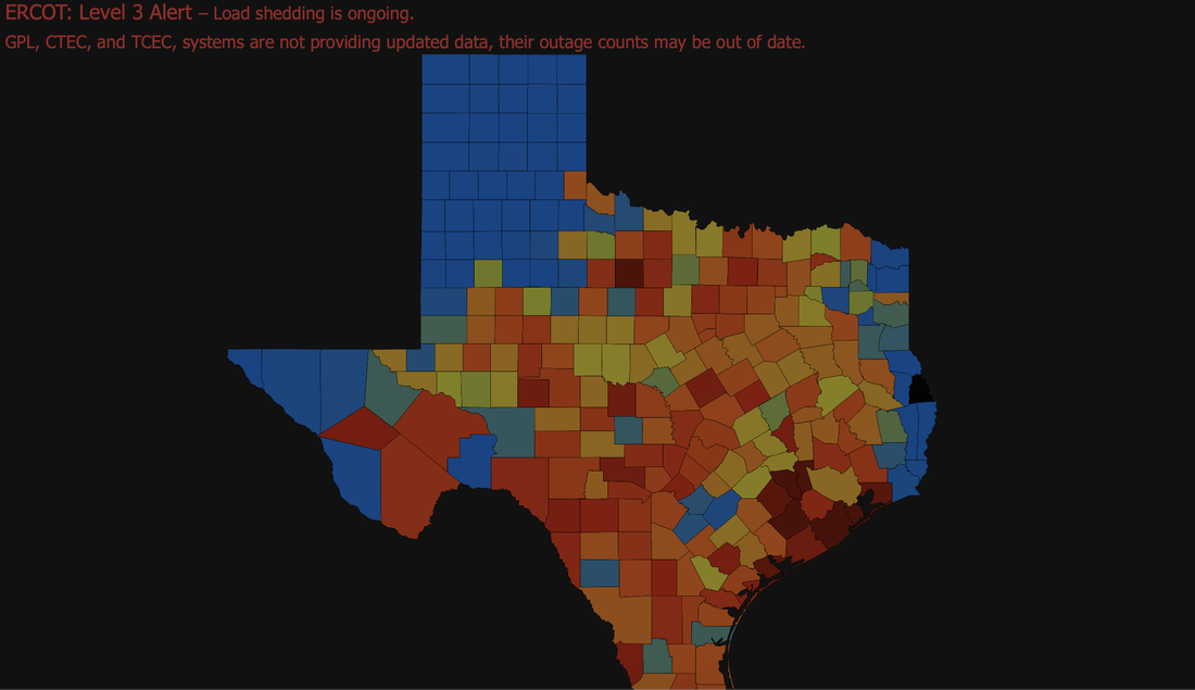 I wish I had good news to share with you all, other than the fact that the sunshine did help just a tad, but not enough to make a difference because of the frigid temperatures. I don't see any improvements on the roads unless they are plowed or until Thursday at the earliest very earliest. WINTER STORM #3 - Our last potent winter storm of this series will impact portions of North Texas, but mainly into East Texas tomorrow night into Wednesday with potential for enough snow and ice accumulation to continue major travel impacts and power outages into Thursday. WATCHES/WARNINGS - All of our North Texas counties are under three warnings... A Hard Freeze Warning is in effect for all counties in North Texas until 12:00 PM tomorrow. A Wind Chill Warning is in effect for all counties in North Texas until 12:00 PM tomorrow. A Winter Storm Warning is in effect for all counties in North Texas until 6AM Thursday morning.
PLACEMENT: The main impact will come in the Winter Storm Warning area. An additional 1-3 inches of snow is possible across the region, which the northwestern side of the region potentially seeing 2-4". For the southern 2/3's of our area, such Waco, Temple, Coriscana, etc., I expect most of your impacts to come in the form of freezing rain, some of which can be heavy at times. That will cause re-icing on most bridges, overpasses and roads. For now, expect another round of snow for all of North Texas, including the Dallas/Fort Worth Metroplex Tuesday evening through Wednesday. However, freezing rain and sleet will also be an issue along with the heavy to moderate snow at times. A change to freezing rain is a good possibility across DFW and points to the south and east as the system skirts eastward with time. Places like Corsicana, Tyler, and Palestine could see a half an inch or more of freezing rain with this event. Some freezing rain is possible as far north as the I35 Junction in Denton county. But again, for most of those in the Winter Storm Warning, it will mostly be snow, some sleet, and freezing rain, in that order. TIMING - The precipitation will come in two phases. The first round will come in a very small window late Tuesday night; light to moderate snow is possible for the northern 2/3rds of the region during that time. Amounts from that will be fairly light, but, it doesn't take much for places to re-ice again, especially since we are still below freezing. The main event will come at around or after midnight for much of North Texas where snow, sleet, and freezing rain will become heavier and more widespread across the winter storm warning area. Impossible travel conditions will continue across the region, and a final layer of ice on top of the snow that has already fallen, including on top of trees and power lines. Precipitation will be over by Thursday afternoon for most of the North Texas region. Roads across the region could remain icy and dangerous all the way through Friday, since temperatures will not reach above freezing until then, even with sunshine. IMPACTS - Not only will be looking at the potential for more heavy snow, but freezing rain and some sleet will be possible. Ice accumulation of .10" to .25" is likely, with additional .40" spots as well. Travel will remain difficult, if not impossible in many areas due to a fresh coating of ice on roads and surfaces. Rolling power outages are likely statewide. This will be a more impactful ice storm for areas to the south and east of the metroplex. 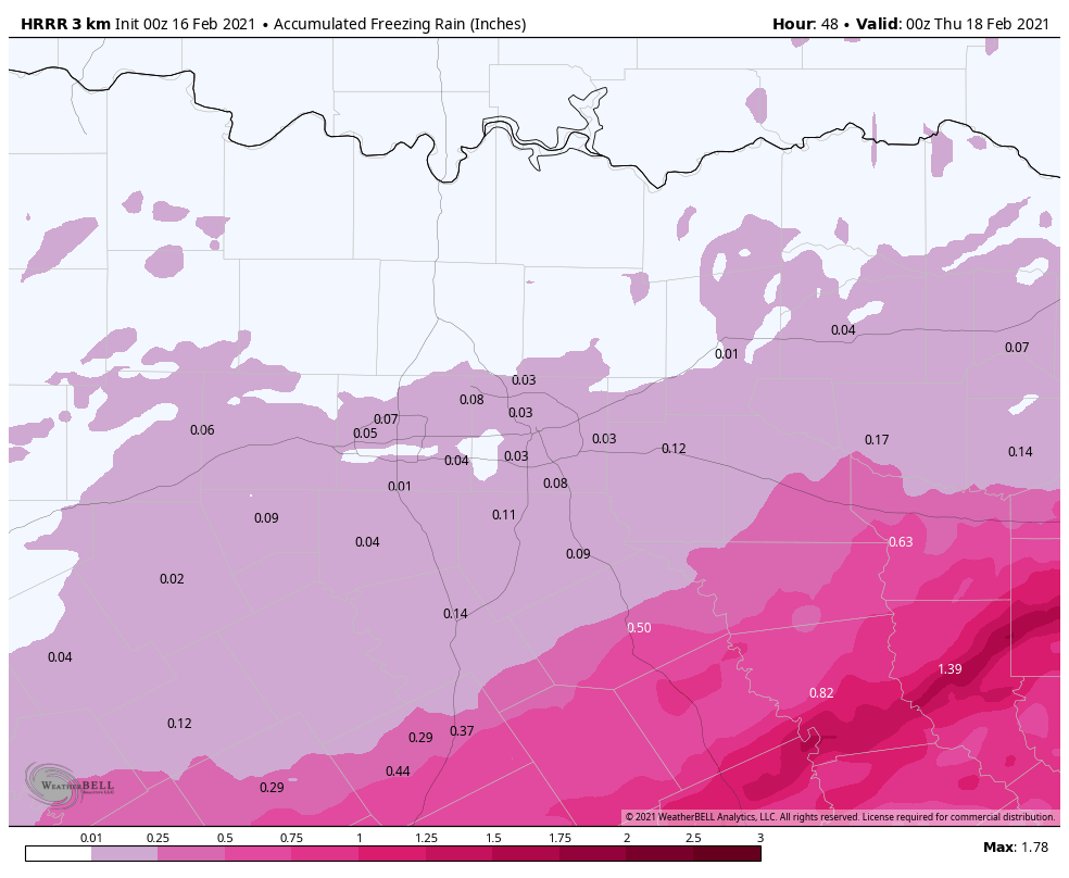 REMEMBER: When we release a snowfall map tomorrow, the boundaries won't be in straight lines like the maps we show you; they are simply used as a guideline. But understand that some places in the winter storm warning will see little to no freezing rain and all snow, while others will see just freezing rain.
More forecast adjustments are possible tomorrow. If you are reading old information, you are working with bad information. PREPARE - Use tomorrow to prepare as much as you can around the house... *Be sure all of your phones, tablets, and other devices are fully charged. *Travel is highly discouraged. If you MUST travel, create an emergency supply kit for your car. Include jumper cables, sand, a flashlight, warm clothes, blankets, bottled water and non-perishable snacks. Keep a full tank of gas. Have cat litter or sand to help tires get traction, or road salt to melt ice. *Gather supplies in case you need to stay home for several days without power. Keep in mind each person’s specific needs, including medication. Remember the needs of your pets. Have extra batteries for radios and flashlights. *Turn your refrigerator and freezer to their coldest settings. *If you lose power and you plug a generator into the house electrical system, turn the main off in the breaker box. Otherwise it can be very dangerous for the crews working to restore power. *Understand some could be without power for more than 24 hours with very cold, sub-freezing temperatures. Have an alternative source of heat. And, use it safely. CONNECT - You can find me on all major social media networks... ApexStorm Text Messaging Join Link Donovan Neal Owner - ApexStorm Before I talk about this region specifically, I would like to point out that Winter Storm Watches or Warnings are in effect for ALL counties of Texas. The entire state of Oklahoma is under a Winter Storm Warning... 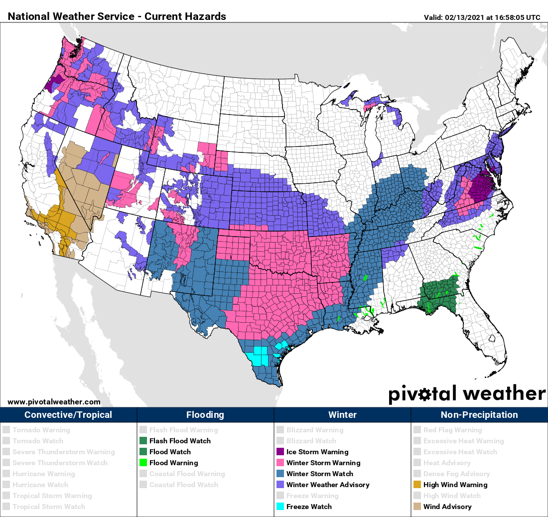 Persons within a winter storm watch will likely be upgraded to a Winter Weather Advisory or a Winter Storm Warning later this afternoon or evening. However, I encourage you not to get hung up on the exact verbiage of these advisories. The main point is, we are expecting accumulating winter precipitation and brutally cold weather across ALL of Texas over the next several days. WEATHER FORECAST HEADLINES - This is probably the most strongly worded headlines I will probably ever write during my time forecasting the weather. The truth is, we have not seen such potential for a winter weather event of this magnitude since the Arctic Outbreak of 1989. With the combination of a winter storm that has the potential to bring snowfall, blizzard-like conditions, freezing rain, and sleet for pretty much everywhere in the Lone Star State, followed by the coldest airmass we have seen in more than three decades, this leads me to conclude that this is a generational event; an event that tends to happen once every 30 years.  FIRST CALL SNOW ACCUMULATIONS - We continue to forecast significant amounts of snow for the northern two thirds of Texas late tonight through Monday morning. Just like I said I would, we went ahead and delayed making a snowfall map until this morning at the earliest since the storm is in the West Coast now. Here is our first official snowfall accumulation map, made today at 11:00 AM... 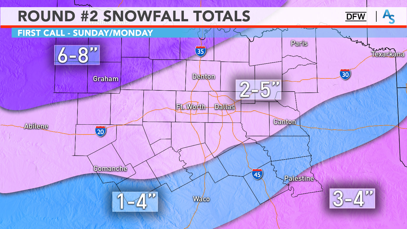 Regarding amounts, it’s still a bit shaky. Keep in mind that this is still on the conservative side of the spectrum, and that any location on this map can see a lot more than forecast. Our NW counties could see 6+ inches of snow, with 2-5” likely in the Metroplex. Yes, it is possible some you see only an inch, some of you may even see 6 inches. It is a wide range due to banding and it is nearly impossible for us to predict, but 100% of North Texas will see snow tomorrow. A good range for us is 2-5 inches with isolated higher and lower totals possible. With temperatures likely in the teens tomorrow afternoon, all this snow will accumulate very easily and travel will be near impossible. Due to gusty north winds and powdery snow, blowing snow will be threat tomorrow and on Monday, even when it’s not snowing. The winter storm warning continues until 6pm on Monday. It is important to note that this storm will not follow these specific guidelines at all. Some places may see more or less snow than what is presented in this forecast, but I think this is a good map; a map that will give everyone in the region an idea of how much snow they can REASONABLY expect. Understand that this map can and will change, even within the next 12 hours. We will probably have another one of these made before you go to bed today. WHAT MAKES THIS WITNER STORM SO DIFFERENT FROM OTHERS WE HAVE SEEN? - Temperatures are currently way below freezing, and will continue to stay that way for a very long time, probably through Thursday. As a result, this winter storm will not be a southern-style winter storm where it snows, and we see roads turn perfectly normal within a few hours of the snow ending. Like I said in yesterday's discussion, this will be a Midwestern style winter storm, where surface temperatures are already below freezing. As a result, anything that falls from the sky, whether it is snow, sleet, freezing rain, etc., will have no problems freezing over, sticking, and turning into ice skating rinks. Additionally, because the air is much drier than with typical snow events in Texas, snow will weigh much lighter. Combined with north sustained winds of 10-20 mph with higher gusts at times, you now mention the issue of blowing snow and near-blizzard conditions, especially for the northern two-thirds of the state. This is exactly why we have been stressing over the fact that travel will become impossible Sunday through at least Tuesday. TIMING: Timing has changed significantly over the past few days. We will be dealing with two storm systems in the next few days. It is now looking like the main event for North Texas from storm #2 will come throughout Sunday, lasting all the way through Monday morning. 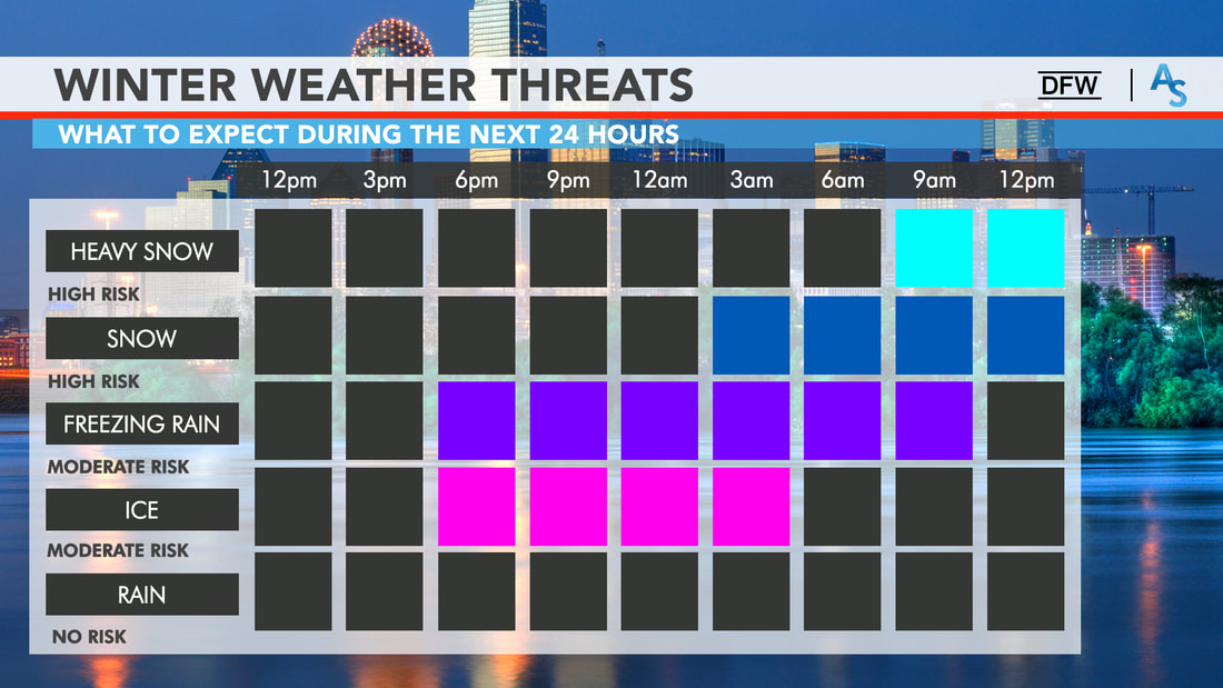 Our first storm system that will affect us is weaker but will be strong enough to sneeze a little winter precipitation before the main storm's onset. Freezing drizzle and rain, and light snow may occur this evening and overnight across North Texas before the main event Sunday morning. While this isn't the main event yet, it is best to not travel when this occurs. Freezing rain creates a glazing of ice on the roads, and it does not take a winter storm to cause major issues on the road ways. The main system will move east overnight, and we could see snow for our far west and northwestern counties as early as the predawn hours tomorrow. Moderate snow should be moving into North Texas, including the DFW metroplex by tomorrow afternoon. Then, a full-fledged mess will unfold for the region by late afternoon tomorrow through tomorrow evening. Most of the snow should be out of the region by Monday afternoon Untreated roads will probably stay undriveable through Wednesday evening at the very, very earliest. HISTORICALLY COLD TEMPERATURES AFTER STORM #2 - As if we weren't cold enough, another brutally cold arctic airmass moves southward on the backside of the departing storm system. This, combined with the cold we are already experiencing, will set the stage for the coldest conditions we have seen in decades by Tuesday morning.
The only way the roads will improve before Wednesday or even Thursday when they get plowed or sanded. Even then, most back roads or untreated roads in residential communities will remain hazardous.
BUT WAIT, THERES MORE! - Another potent upper level storm system will move across the state Tuesday night and Wednesday. Since we have the arctic airmass in place already, this could result in another significant winter storm for North Texas. In addition to what we see with storm #2, several inches of snow is possible for our region again. In fact, this system might be the wetter one with moisture, causing wetter snow and more precipitation than storm #2! This is why I am so adamant that conditions won't start improving until Thursday at the earliest. We will revisit this once we get past tomorrow and Monday. AFTER IT ALL ENDS: - We will be dry for a minute and start slowly increasing in temperature after Wednesday. Even then, we will not see temperatures above freezing until at least Thursday, if the snowpacks melt during that time. CONNECT - You can find me on all social networks... ApexStorm Text Messaging Join Link Donovan Neal Owner - ApexStorm Three Potential Winter Storms With Dangerous Cold This Weekend and Early Next Week For North Texas2/12/2021 One really rough day of winter weather is down in the books. However, we are only a fraction into this entire event, as we have three more potential winter storms to get through over the next five days. Like I said yesterday, not only will this include winter precipitation, but also the coldest air North Texas has felt in decades with some of that cold air already in place as the snow is falling. Definitely not a good combination and certainly not a combination that we are accustomed to. DISCLAIMER: As I mentioned in yesterday's blog entry, this forecast WILL change. I strongly encourage you to only keep up to date with latest information. Remember, if you are reading products that are 16-24 hours old, you are using bad information. READ ME READ ME READ ME READ ME PLSSS: TODAY WILL BE THE LAST GOOD DAY TO PREPARE BEFORE SEVERAL DAYS OF WINTRY PRECIPITATION, DANGEROUSLY COLD TEMPERATURES THAT CAN LEAD TO HYPOTHERMIA AND FROSTBITE IF PRECAUTIONS ARE NOT TAKEN, AND LIFE-THREATENING, HAZARDOUS TO NEAR IMPOSSIBLE TRAVEL CONDITIONS. CONDITIONS WILL SLOWLY START TO GO DOWNHILL SATURDAY NIGHT. FRIDAY: Not as chaotic as yesterday for obvious reasons. We will still need to be on the lookout for freezing drizzle tonight where temperatures are below freezing. That being said, a majority of this blog entry will be focused on tomorrow and early next week. I will post updates about today's conditions on my twitter page if needed. WINTER STORM #1 ON SATURDAY - If you read yesterday's blog, I briefly touched on this. However, I neglected to go into full detail due to some uncertainties. I am getting more concerned about a quick-hitting storm system for much of North and Central Texas for Saturday afternoon and evening. While precipitation mode remains uncertain, this could be a freezing rain/sleet/light snow event for the aforementioned regions. At this time, light snow at times would be the most probable if you are along and north of the I-35W/E Junction in Hillsboro. Conversely, freezing rain and sleet will be more of an issue if you are located so the south of that Junction. In more simple terms in regards to travel, it is possible that roads will start deteriorating in our southern counties by tomorrow evening. Please also be advised that this first storm will not result in a complete whiteout; chances are, you will not see much of any snow fall out of the sky while some areas receive anywhere from a dusting to an inch at best. However, do take notes from yesterday. It does not take a full fledged winter storm to cause major issues on the roads. WINTER STORM #2: THE BIG ONE - I understand that most of you have stayed in the south for most of your life and are not accustomed to Midwest-type winter storms. So, let me preface this section by reminding everybody that when we have winter storms in North Texas, temperatures are generally above freezing in most spots where snow does fall, precluding any extended travel issues after the snow has ended. However, this will not be the case this weekend into early next week. Temperatures will be well below freezing (32°F>) when the snow is falling. This will not only cause dry, powdery snow to fall since the warm air just above the surface is missing, but will also cause long-term travel issues as a result of surfaces already being below freezing, allowing for any precipitation that falls to freeze and accumulate. The drier snow will be more prone to movement by gusty winds, which we will have with this storm. Gusty winds of 10-20 mph with occasionally higher readings is likely. As a result, near blizzard-like conditions are possible, along with the possibility of snowdrifts. HOW MUCH SNOW WILL FALL? - Because the storm system responsible for causing this event is not in our upper air network yet, I will refrain from giving away exact forecast amounts. Instead, I will say that everyone in North Texas has a chance of receiving anywhere from 2-7 inches of snow. Isolated higher amounts are possible, of course. Once this storm system arrives in the West Coast tonight, expect a snowfall map from us as early as potentially tomorrow morning, when we will have access to weather balloon data, as well as higher resolution guidance. WHEN WILL IT GET HERE? - The simple answer is that no one truly knows an accurate answer to that yet. Light snow will already be taking place across the Panhandle by Saturday afternoon and evening, quickly spreading into West Texas during the overnight hours. Precipitation will quickly increase in size and intensity as it slowly begins its journey to the east over the rest of the Lone Star State. Forecast guidance has tried to speed the system up in the last couple of runs, resulting in a mostly Valentines Day event with precipitation ending across East Texas by daybreak on Monday. Others have continued to display a Sunday evening - Monday afternoon event. Like I mentioned previously, we will get a better handle on the timing of this system tomorrow morning. HOW COLD WILL IT GET? - Another surge of arctic air will reach the North Texas area Monday night through Tuesday morning. As if it can't get any colder, this will create the coldest airmass North Texas has seen in decades. Morning lows on Sunday will be in the teens, followed by single digits on Monday, finishing off at near or below zero on Tuesday morning. These are morning lows that I am talking about. Not wind chills. In the worse case scenario, we will see wind chills around 20 below zero for several areas in North Texas. IMPACTS - This will be an extremely dangerous situation for those who are caught traveling in this. With near-blizzard conditions anticipated at the climax of this event, travel will become nearly impossible. I cannot stress how dangerous it will be to travel on Sunday, Monday, and even Tuesday for all of North Texas. It may last several days for the communities that receive significant snowfall/ice accumulations. Power outages are likely in the places we see significant snow and ice buildup on trees and powerlines. Some power outages are possible due to the extreme cold, which will increase the demand for energy. All pipes will be susceptible to bursting if not insulated properly. Hypothermia and frostbite will be possible for those not dressed appropriately. Additionally, we will need warming shelters if the winter storm results in widespread power outages and stranded travelers. Ice and snow will exist on the roads for several days or until road crews are able to plow through the snow drifts. STORM #3 - I alluded to this in the last discussion, but long range forecast guidance suggests the potential for yet another winter storm for much of North Texas either Wednesday or/and Thursday. This would only delay recovery efforts from storm #2. To mitigate the risk of information overload, I will get into more specifics once we through the event this weekend. :-) MAP LITERACY - Just about anytime we forecast extreme weather, we get dozens of messages that consist of "what about *insert town or city here*". Most of these messages come on posts with references to counties or major highways in North Texas. In my five years of doing this, I have learned that several people struggle with geography, and more specifically have a tough time trying to read maps. I understand. I struggle with many things to. If you were to give me analytic geometry questions, I would look at you like you just shot a man before my eyes. But there is no way we can name hundreds of municipalities in North Texas on every post. I encourage you to take a few minutes to learn the major highways and counties relative to your location. I promise it will help you understand the blog entries and the posts I make here addressing any time of weather extreme.
CONNECT - You can find me on all of the major social networks...
ApexStorm Text Messaging Join Link Donovan Neal Owner - ApexStorm FREEZING LINE: The freezing line is south to a line from Marathon to Rocksprings to Boerne to Giddings to Jacksonville to Clarksville. The line represents where temperatures are 32° or below, or, for simple terms, where it is below freezing. As you can see, a majority of the Lone Star State fits under that category right now... 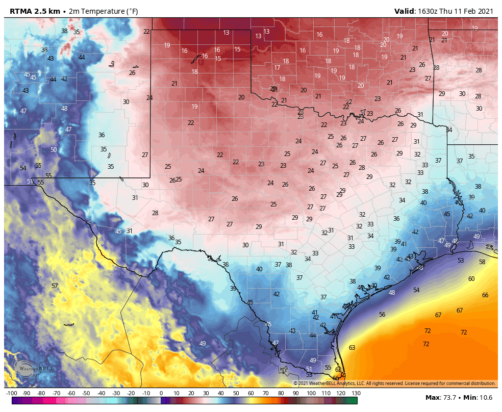 As we saw this morning, the rain, combined with below freezing temperatures, resulted in freezing rain causing ice accretion on several major highways, roads, bridges, and overpasses. Dozens of accidents were reported this morning across the region, and they still continue to come in. A mass casualty incident is taking place in Fort Worth on I-35W just after I-30, where a 100 car pileup occurred, resulting in at least six fatalities.
Fortunately, for the DFW Metroplex, freezing rain has tapered off for the most part, and will continue to do so throughout the afternoon. That should prevent new issues of icy bridges for the rest of the day. The Winter Weather Advisory for DFW will expire at noon today. At the same time, freezing rain will continue for some of our southern North Texas counties, where it will be their turn to experience freezing rain and ice accumulation. FREEZING RAIN CONTINUES THIS AFTERNOON IN SOUTHERN NORTH TEXAS - There are increasing concerns over ice accumulation over than a quarter of an inch over much of Southern North Texas and Central Texas this afternoon. This will lead to not only hazardous travel, but extensive tree damage and power outages. A Winter Storm Warning has been issued for the counties outlined in magenta on the graphic below to address this concern. 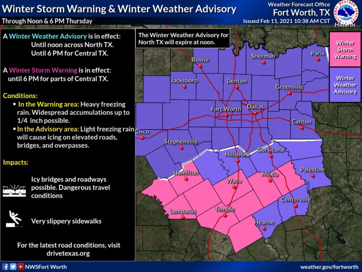 Another great concern is that temperatures will likely have issues rising above the freezing level over the next few days. We have a significant winter storm brewing in the next few days, which would weigh down trees and power lines even more. WINTER STORM EXPECTED FOR MUCH OF TEXAS SUNDAY NIGHT INTO MONDAY - Another surge of arctic air is expected to arrive on Sunday, resulting in a MAJOR temperature drop for ALL of Texas. This is not just cold air that I'm talking about, I am talking about the coldest airmass we have seen in decades. However, most of you are not really concerned about how cold it is going to get next week, but are more focused on the precipitation aspect, so I am going to save the discussion on temperatures for the final part of the blog entry. DISCLAIMER: THIS FORECAST WILL CHANGE, CONSIDERING HOW THE STORM SYSTEM RESPONSIBLE FOR THE EVENTS SUNDAY THROUGH MONDAY WILL NOT ENTER THE AMERICAN UPPER AIR NETWORK UNTIL FRIDAY NIGHT. Long time followers of ApexStorm know that I do not 'hype' these events (sharing the most eye-catching snowfall maps, or posting the worst case scenario) in an effort to get likes, clicks, shares, follows, and retweets. I have been doing this for five years, and know all of the people on Facebook and Twitter that will use scary maps and verbiage to elicit a reaction from the general public. That's not me. I try and share the information I know with the experience I have, explain the uncertainties, what we don't know yet, and go from there. Keep that in mind as you continue reading and as you read the subsequent blogs in coming days. BEHIND THE SCENES: The long-range weather analysis has done an excellent job illustrating this arctic air outbreak over the past two weeks. Guidance in that sector continues to agree on Sunday and Monday. Deterministic weather guidance continues to disagree on snow totals and timing. Like I have said before, looking at deterministic weather output is not helpful at all. This far out, it is best to use ensemble model output, as well as probabilistic forecasts. An ensemble is a set of forecasts that present a myriad of future meteorological possibilities. Each simulation has a slight variant in its' initial conditions and with slightly skewed weather models. These simulations represent uncertainty in the initial conditions and approximations in the models. For a more simple definition, the name is derived from a range of possible weather conditions. The ECMWF-EPS (European Ensemble Model) suggests the chance of snow greater than one inch for North Texas is about 90-100 percent. Meanwhile, the GEFS ( American Ensemble Model) shows the same thing. Point being, confidence is high that a significant winter storm resulting in major impacts over a widespread area late Sunday into early Tuesday morning. TIMING: Snow will be in progress Sunday afternoon and evening over parts of the Texas Panhandle into Northern West Texas. For North Texas, scattered to perhaps widespread sleet is possible throughout the day on Sunday. That being said, you will not see sleet all day, just sleet at times, and certainly might be enough to cause travel issues due to the surfaces already being below freezing. By the overnight hours, snowfall rates will significantly increase and become more widespread out in West Texas as it moves east overnight. SNOW TOTALS AND IMPACTS: Significant snow accumulations are forecast. For now, we are going with 3-6" over the North Texas region. However, based on latest guidance, I may need to raise those numbers in later updates. Gusty winds from the north at around 15-20 mph with gusts of up to 30+ would result in blowing snow and snowdrifts. This will be a scenario where travel will be extremely difficult to near impossible for not only North Texas, but for much of the state. It is looking like 100% coverage for a good part of this event in North Texas. I must remind everyone again, we are still hypothesizing about many of this storm's features, considering how we need it to be in at the US West Coast to get weather balloon data on it, and that will not happen until Friday. That is why I must state again that this forecast will change in the coming days. As we get closer to the event, we will be able to narrow down specific precipitation types, timing, accumulation totals, and temperatures during and after the event. Winter Storm Watches will be issued by the National Weather Service Office in Fort Worth once we are within a few days of the winter storm’s onset. DANGEROUSLY COLD AIR EXPECTED EARLY NEXT WEEK: While a brutally cold airmass is already in place during the winter storm, more arctic air will usher in from the north as the storm exits the region Monday night into Tuesday, creating the coldest airmass Texas has seen in decades. To make matters worse, because extremely cold air will be in place before the snow begins (rare in North Texas) there is a chance many areas will see snowpacks - layers of snow that are incredibly slow to melt. In that scenario, to get a more accurate understanding of what the low temperature may be, subtract five to ten degrees from the numbers on that map. Yes, that would result in near or below zero low temperatures for North Texas on Tuesday, and we are not even talking about the wind chill. Wind chills, in that scenario, would be ten to around 20 degrees below freezing across the region Tuesday morning. Yes, that means danger from the cold will be a real threat, as many will not be informed as to how cold it will really get. Additionally, we could have a real issue with people needing warming shelters if the winter storm results in widespread power outages or stranded travelers.  CRAP APPS: For those who did not see my story on Snapchat yesterday, I have received literally dozens of stories and comments from people telling me what their weather app is showing.
Look, I understand the convenience of the app that is preinstalled on most smartphones. It is insanely convenient! you open it, you are shown a symbol with the high temperature, a low temperature, and a chance of precipitation. In a complex, active winter pattern such as this one, automated apps and websites are pretty much useless 5-6 days in advance (sometimes 24-48 hours as well). They use computer model data which can be absolutely horribly inaccurate in a time like this. They do not provide ANY context, and, most importantly, does not communicate uncertainty at all when forecasting. There is going to be range of possibilities and it takes a little more than a glance at an app on a phone to understand the complex weather pattern that we are in. So, I would use great caution while you are looking at an app, and I will leave it at that. :-) LATER IN THE WEEK: Temperatures will be hard-pressed to rise above freezing across Northern Texas until any snowpacks begin to melt. Speaking of snow, we are tracking another chance of a winter storm across North Texas next Wednesday into Thursday. But, I think I've talked enough for one blog post. BE INFORMED: I know I have many first-time readers here. So I would like to say welcome and thank you for taking the time to read my products! I will have many more as we get closer to this event. If you would like frequent weather updates from me, please follow my Twitter @donowx. Please also like our Facebook page linked here. Also, please join our text messaging system to receive daily forecasts and updates by texting @apexstorm to '81010'. Or click the link. Donovan Neal Owner - ApexStorm WEEKEND UPDATE: Happy Super Bowl Sunday everyone! A great game is slated for today and I think it’d be easier to predict the score of the game than next week’s forecast as there is so much uncertainty. I’ll detail everything you’ll need to know about next week and what to look out for! EARLY WEEK: Monday and Tuesday will be relatively cool days with some overcast skies and occasionally breaks in the clouds. An arctic front will slowly be approaching North Texas as the week progresses so each day will become cooler and cooler. While the initial front will move through Oklahoma on Monday, it won’t make it to DFW until midday Tuesday, as it slowly encroaches upon the region. The arctic air mass is relatively shallow, so while we know it will come into North Texas sometime on Tuesday, it’s hard to know how quickly it’ll move through, and how deep the cold will be. The GFS and Euro have it fizzling out and staying relatively warm (in the 50s and 60s) through Wednesday, whereas the NAM shows a brief warmup period early Tuesday with another drop in temperatures as DFW struggles to get out of the 40s. Typically, models struggle with shallow cold, so expect wild temperature swings in the forecast for the next few days. In addition, some of the mid range models are indicating the potential for freezing drizzle overnight Tuesday into Wednesday as the arctic air seeps its way into Texas. The initial front on Monday/Tuesday won’t have any moisture associated with it but there is a low chance of it occurring overnight Tuesday. However, it’s extremely minimal so don’t anticipate any wintry weather for the first part of the week. ARCTIC BLAST: Cold air has been building up in Canada for a few days as Greenland Blocking and global teleconnections have set up conditions for a proper arctic blast. A ridge of cold air will move southward and make it to NTX sometime later in the week. There are large differences between the models as the ICON and GFS are forecasting extremely cold temperatures (as low as the single digits for Valentine’s Day) due to a stronger front with more arctic air, whereas the Euro slows the progression of the front and limits temperatures. On Wednesday, there’s decent potential for moisture, however most of it will likely be a cold rain. That being said, there is low confidence in a potential ice storm taking place overnight if the air moves quickly enough. In addition, there is some general instability that could facilitate a few thunderstorms south of DFW along the boundary of the air mass. While it’s unclear what will happen with that moisture overnight, it’s likely that it won’t have any travel impacts on the region. It’s generally agreed upon, however, that by Thursday, temperatures will be in the 30s and possibly dip down into the low 20s overnight. And, as the weekend approaches, temperatures are supposed to decline—it’s just unclear by how much. Also, as we shift to a period of cooler temperatures, it’s possible we might have multiple shots at winter weather, with ice storms, freezing rain, and snow all shown as a possibility over the next 10 days, with multiple chances for precipitation. It’s hard to hone in on one example due to high model disagreements over the progression of the arctic airmass and global oscillations that affect larger air mass movements and pressure systems. Ensemble guidance is promising but continues to change, so it will be something to monitor as we progress through the week. For now, enjoy the last few mild days as it starts to get colder next week. Stay warm, stay safe, and stay weather aware! -Colin Welty
Hello ApexStorm readers! I’m here with another weekend update where I’ll detail the upcoming week and what weather North Texas is set to experience! There’s not too much to discuss as it’s a relatively mild week ahead of us, so it’ll be a shorter blog today.
EARLY WEEK: Monday will be a slightly cool day with temperatures likely not making it out of the 50s. Sunshine will be at a premium with scarce cirrus clouds possible from time to time. After an extremely windy weekend, wind will start to subside with gusts only reaching about 20 mph. A small chance for hazy skies due to drought-induced dust from West Texas will still be possible but it will likely be less prevalent or intense as it was over the weekend. A freeze is possible overnight for the Red River counties, but most of North Texas won’t dip below freezing the entire week, unless a temperature bust occurs of course. These are often unpredictable but I see no reason that should occur. Tuesday will be seasonal February temperatures in the upper 50s and low 60s with clouds lingering in the morning. Wind will also be lighter this day. MIDWEEK: Some seasonably warm temperatures will be present Wednesday and Thursday as temperatures climb into the high 60s both days and potentially low 70s on Thursday. Some stronger southerly winds are possible both days as a surface level low approaches our area. Thursday will also be a slightly more humid day with more clouds as a result of the low. LATE WEEK COLD FRONT: Attached to the surface level low will be a cold front that moves in sometime late Thursday with a high level of uncertainty regarding the potential for precipitation. I’m guessing a low level of precipitation at this point with coverage of around 30%. The air mass behind the front is much colder and drier and will keep temperatures much cooler for the weekend. There is also pretty strong model guidance for an artic blast occurring over the weekend and into the following week that will bring much colder temperatures and the potential for winter weather a week from tomorrow. However, it’s extremely low confidence and will definitely require another blog update in the future. For now, stay safe, stay cool, and stay weather aware! -Colin Welty Hello ApexStorm followers! I’m here with another blog update specifically focused on the upcoming winter storm for NTX. I’ll construct this blog a little differently than I normally do but even as we are less than 24 hours out, we’re still dealing with many uncertainties. And yes, I said snow. I’m pretty confident now that DFW will end this snow drought. WHAT WE KNOW: An upper level low is currently sitting over Colorado and is forecasted to move over Texas, starting tonight in the panhandle and moving through Texas until Sunday night. Associated with the upper level low will be a larger amount of QPF (precipitation) than normal due to higher gulf moisture and seasonably cool temperatures. The blocking pattern and upper level dynamics match up nicely to previous major snowstorms in DFW’s history, reminiscing the famous February 2010 snowstorm where parts of the area got a foot of snow. These upper level dynamics are extremely complex and result in a high potential for variability due to the possibility of snow banding and heavy rates of snow, in addition to thermal cooling from high precipitation rates. We also know that areas south and west of here, in places such as Abeliene, Lubbock, and Waco, will receive measurable snowfall. While it’s extremely likely that DFW will receive a dusting, we can certainly say the aforementioned regions will get snow. The track of this low will vary but there is enough guidance from the models showing snow that there will likely be some high totals across Central Texas. WHAT WE DON’T KNOW: The track of the ULL can still change. Models have somewhat come to a consensus that the low will travel across Central Texas, but it could still change by upwards of 50 miles. This track, if more southern, would likely leave DFW with only a dusting. If it went more northern, however, we could be seeing a multi inch storm. It’s extremely complex and we likely won’t know the track of the low until mere hours before. In addition, this setup is conducive for heavy banding of snow. These bands of snow are highly erratic and difficult to predict. While we’re pretty certain on where the higher snow amounts will be, localized heavy bands are likely across all parts of Texas. These localized bands could drop up to 4 inches of snow regardless of where they pass and cool temperatures, which means that anyone who gets a band over them will have higher snowfall amounts than areas around them. The timing of the changeover will also influence amounts. Global models are calling for the switchover to occur after noon, while high resolution models are calling for the switchover before noon. QPF will maintain regardless of what precipitation type it is, so the earlier the changeover, the higher the amounts. 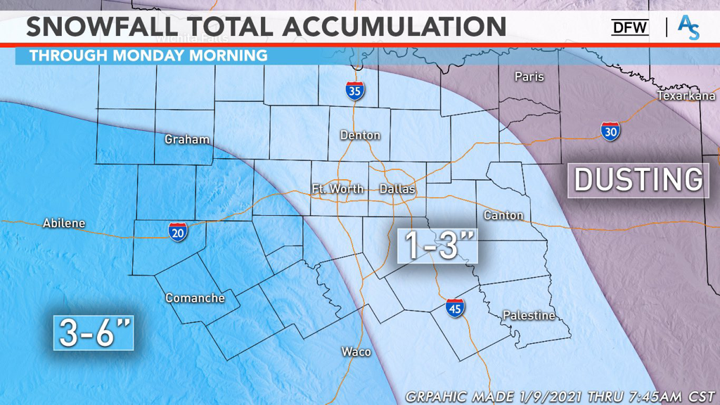 WHAT WE ARE PREDICTING:
The Red River down to the edge of the metro area will likely only see up to an inch, if even a dusting. We’re calling for the bulk of the DFW metro to see between 1 and 3 inches of snow with the potential for higher amounts with localized banding. Areas south and southwest of DFW will see between 3 and 6 inches of snow with localized heavier amounts possible as well. This forecast lines up with most of the professional meteorologist’s opinions as well, such as the legendary Steve McCauley, who is calling for 1-3 inches for DFW as well. This forecast is just that—a forecast. It is SUBJECT TO CHANGE right until the event and we have moved into nowcasting. Pay attention to radars and local meteorologists as this has the potential to be a massive bust or a massive over-performing system. For now, stay warm, stay alert, and stay weather aware! -Colin Welty 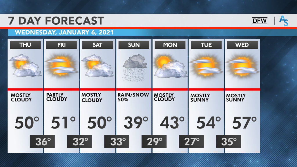 Hello everyone! I hope everyone has been paying attention to some of the chatter around the weather community lately because there is an extremely exciting potential for some wintry weather this weekend. I’ll talk briefly about the end of this week but I’m also going to be focusing a lot on what could happen this weekend and what to look out for. I also want to let everyone know that very soon, I’ll be putting out updates for OKC and Southern Oklahoma as part of our expansion for ApexStorm! I’m really excited for that opportunity and we’re finalizing a few things before we get everything started.
END OF THE WEEK: The persistence of a fairly gloomy pattern will result in relatively cool temperatures today with most of the region failing to get out of the 40s. There’s a minimal chance of some spotty showers here and there but it will likely be a cold, overcast day for much of North Texas. Temperatures will largely remain the same for Friday with DFW barely reaching the 50s, seeking up for a likely freeze taking place overnight into Saturday. The clouds will break at some point on Friday, giving way to pockets of sunshine to break up the otherwise dull, gray clouds. Saturday will be really similar to Friday as well, but as it transitions into the night, it gets a lot more interesting. DOES DFW BREAK THE DROUGHT: Wintry weather is a fickle part of weather around here. Some years it’s easy to get multiple events. Other years are more of the snowless status quo. This winter has, so far, been a continuation of the last 5 years. DFW hasn’t seen any snowfall greater than an inch since March of 2015, making it the 3rd longest drought in recorded history. It’s been difficult, time after time, seeing what looks to be a promising signal of winter weather, only to be left with flurries at best or cold rain at worst. However, this weekend could be the end of that drought. A classic bowling ball low is projected to sweep across Texas from the pacific overnight Saturday and through Sunday. This type of upper level pattern has a history of bringing snow to all parts of Texas and is ripe for both cold air and moisture. If you are wanting to see a good snowstorm, this is exactly what you want. In addition, the larger scale blocking patterns are also extremely promising, reminiscent of those back in February of 2010 when DFW set the record for highest snowfall in one day. Most of our near misses haven’t had a good upper level pattern like this—it’s always been a case of trying to find the cold when we have moisture, or trying to find moisture when we have the cold. However, while this pattern is precisely what we want for snow, it doesn’t guarantee it. The model guidance, then, becomes very important for our confidence on what might happen this weekend. In general, there have been two predominant solutions shown by the models. One solution was to have a fairly strong low pressure system move southward over Texas and into the gulf, bringing the bulk of the snow to Central Texas. The other solution was to have a weaker disturbance move over central texas and take a more northern track, resulting in more snowfall north of Interstate 20. These two conflicting solutions had made it difficult to forecast what would happen over the past few days. However, just in the last few runs, the models have all trended towards a different, compromising solution: a stronger, more northern low tracking over Texas. The amount of precipitation we have won’t be an issue, as there is almost unanimous agreement that North Texas will see a lot of moisture. The question now becomes about where the upper level low will track and where the freezing line will be. We’ve come to a general conclusion that a wintry mix is likely and it’s probable to see some light snow on Sunday. While model runs have shown the possibility for convective banding and genuine snowfall accumulation, it’s best to wait it out a few more days and see what trends endure and what trends fade. What we do know is that ensemble guidance is already showing some of the strongest signals for winter weather in the last decade and anything is possible this far out. We’re keeping it at a modest 50% wintry mix for Sunday, but we encourage everyone to continue to follow along for future updates. Nothing is off the table and be prepared to make adjustments to your schedule if trends continue. It’s been a long time since DFW had good snow and this storm is shaping up to be our best shot in years. As we get closer to the weekend, continue to follow along with the NWS and your local mets to see how this situation develops. If this were a drive in football, an interception would be just as likely as a touchdown. Stay alert, stay warm, and stay weather aware! -Colin Welty WINTER(?) - Albeit a bit cool, today was an absolutely pleasant day, especially the afternoon; I could not find a cloud in the sky as I was driving to Plano today! A very weak cold front, which resulted in a wind shift to the northwest, helped to keep the winds speeds up this afternoon. Due to the abundance of dry air just above the surface, no precipitation is expected through the rest of the evening. We will be chilly overnight, as always, with temperatures in mid 30s across North Texas. Mid to upper level cloud cover combined with radiational cooling will allow patchy fog to develop in most low-lying spots across the region tomorrow morning. Although a majority of the fog should be relatively shallow, a few dense areas is not completely out of the question. Make sure to exercise caution if you encounter any of those spots while driving. Not much change during the day tomorrow and Tuesday. Another mostly sunny, pleasant day is expected with temperatures in the low to mid 60s. Make sure to go outside for at least 30 minutes and enjoy it because we are supposed to be in the mid 50s around this time of the year. WEDNESDAY THROUGH FRIDAY: Another cold front will enter our northwestern counties Tuesday night, exiting the southeastern counties by Wednesday evening. Convergence along the cold front will lead to Isolated to scattered showers and storms ahead of the cold front. Not everyone will see rain; the best chance of any particular spot getting wet is about one in three, with the highest chances to the east of Interstate 35, where the highest moisture content lies. The lack of CAPE (instability) will keep any threat of severe weather to a bare minimum. Rain totals should be very light across the region, ranging from a trace to the northwest to about a half of an inch to the southeastern areas. Highs will be in the upper 50s to low 60s. Then, we go back to fairly quiet weather on Thursday and Friday. Same forecast ensues with partly cloudy skies, highs in the low to mid 60s, and overnight lows in the 30s. THE WEEKEND: Saturday will feature a mix of sun and clouds with highs in the low 50s. By Sunday, a surface low develops near Big Bend, tracking towards the Gulf Coast, bringing precipitation a large part of the region. Global models have been showing winter precipitation in our area, however, because of certain model's natural cold bias, will forecast any precipitation as all rain at this present time, some of which may be heavy. For now, we will roll with more clouds than sun and highs in the mid 40s. NEXT WEEK: Fairly tranquil weather for at least early next week. We go back to at or below normal temperatures with highs in the 50s. A mix of sun and clouds is expected each day. 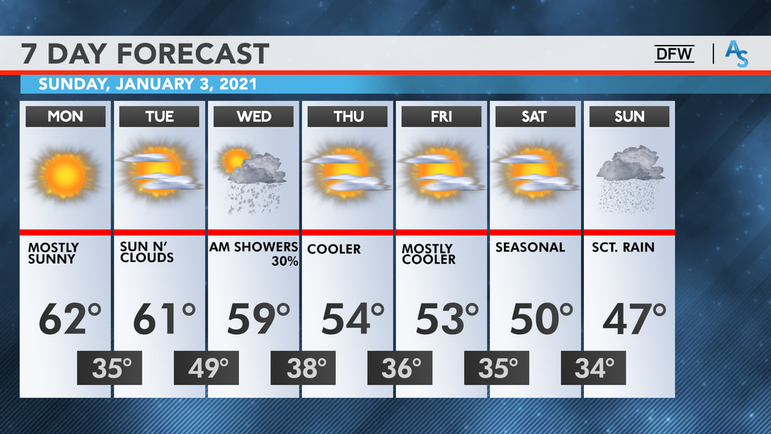 Colin and Logan should be back from vacation this week, so expect the next blog entry on Sunday! Enjoy the week!
Donovan Neal Owner ApexStorm Hello North Texas! We have a really exciting weather week ahead of us and so many possible outcomes could happen just in the span of a week. I’ll try my best to give a brief overview of everything and some of the events might warrant a second blog post soon.
EARLY WEEK: The rest of Sunday and Monday will be relatively uneventful, with highs in the 70s today and a cloudy day in the 60s on Monday. However, by early Tuesday morning, moisture from the gulf is expected to bring some brief showers. It’ll be relatively seasonal with temperatures in the 60s as precipitation starts around midnight, and it will linger throughout the day with spotty showers and low stratus clouds making it an overall gloomy day. The moisture will be ahead of an upper level low that is projected to track over Texas starting from the Mexico/New Mexico area, and that upper level low provides for a tricky but intriguing scenario on Wednesday. SEVERE WEATHER AND SNOW: The track of the upper level low will determine exactly what happens in the next few days. Wednesday is probably for some severe weather near the metroplex, as the low sweeps through Texas. A few thunderstorms can’t be ruled out for DFW proper, but there’s differing model solutions for exactly where and how severe the weather will be. The global models have a wider swath of precipitation whereas the NAM has a tighter squall line. I think the DFW metro area will likely see some morning storms without a chance for hail, with a potential for some strong winds and thunder. However, as this upper level low tracks across Texas, we have a very decent chance at some wintry weather. While a wintry mix is the most likely solution, the track of the low could turn that into more substantial wintry weather. We won’t have any issue with QPF (precipitation) which places it all on the track of the low. The CMC and UKMET shows a very low, deep trough, with plenty of wrap around snow in the DFW area, with accumulations of around 4 inches. The GFS, however, pulls back with the trough and shows higher accumulations in Central Texas, with only a dusting in NTX and more prominent ice accumulations in DFW due to a stronger warm nose. The NAM isn’t quite at a good range and doesn’t show anything yet for Texas, but the Euro and the NAM look to be heading towards a mix of the two solutions and I would mostly agree. I think, just for caution’s sake, to plan on a wintry mix that develops as a changeover on New Year’s Eve, with a light dusting of snow overnight into 2021. For how poor 2020 has been for mostly everyone, ending it with a little bit of winter fun would be the perfect way to transition into the New Year. We here at ApexStorm will keep you up to date! Stay warm, stay safe, and stay weather aware! -Colin Welty |
Archives
March 2023
Categories |
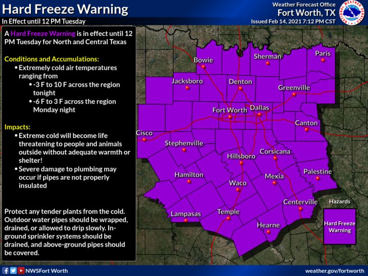
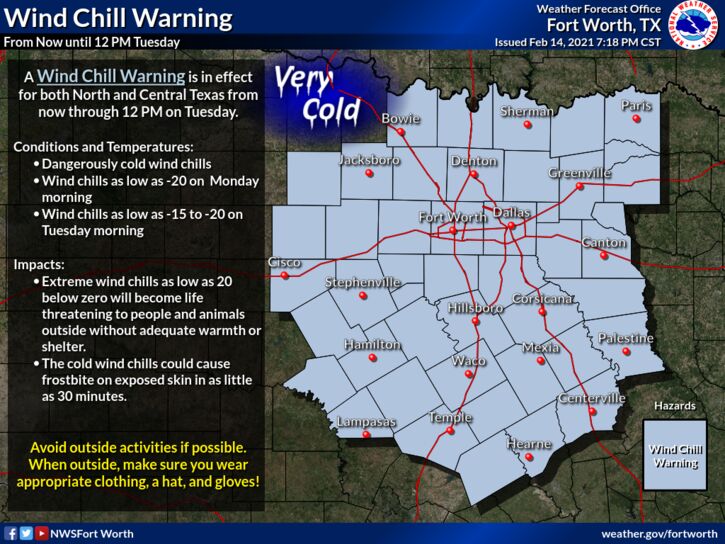
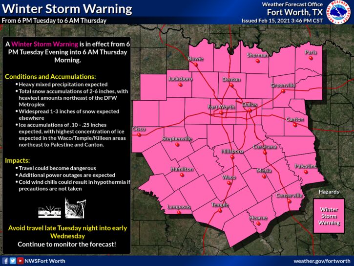
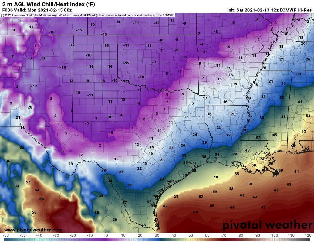
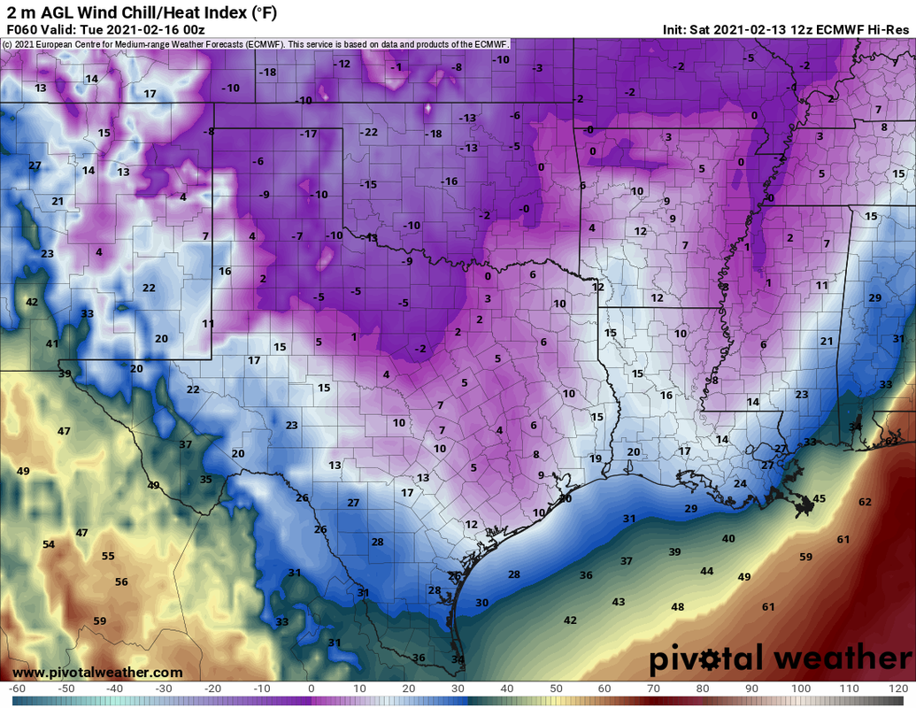
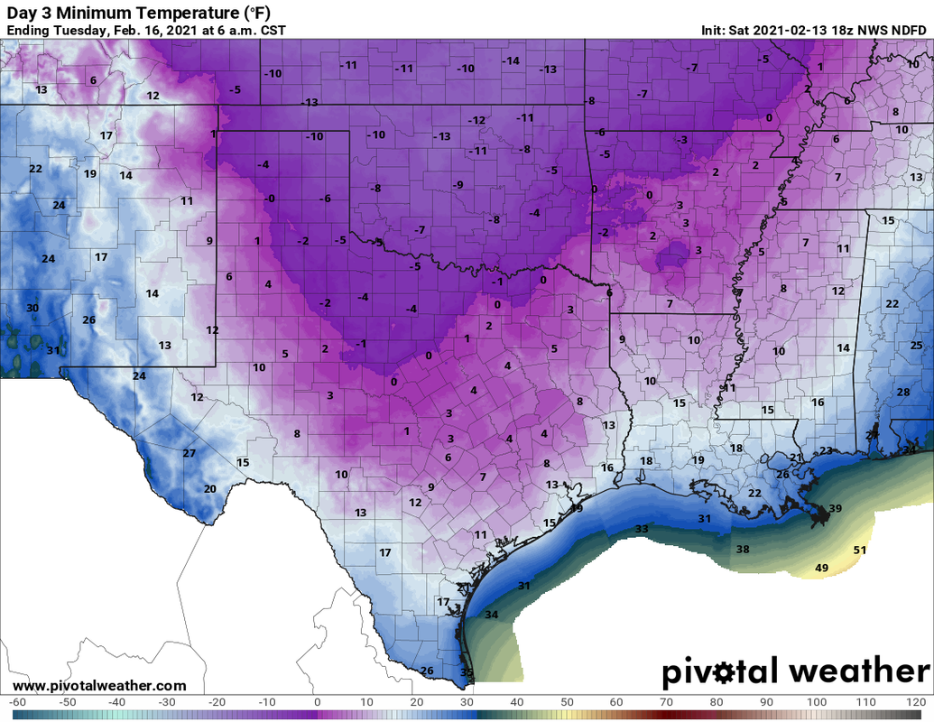


 RSS Feed
