
|
Current surface observations show that the cold front has already moved through the metroplex. As previously mentioned in yesterday's blog entry, this is about 1-3 hours ahead of what the mid-range mesoscale models were showing. Gusty winds and a wind shift to the north can be expected throughout the day, in addition to plunging temperatures before the winter storms' onset. 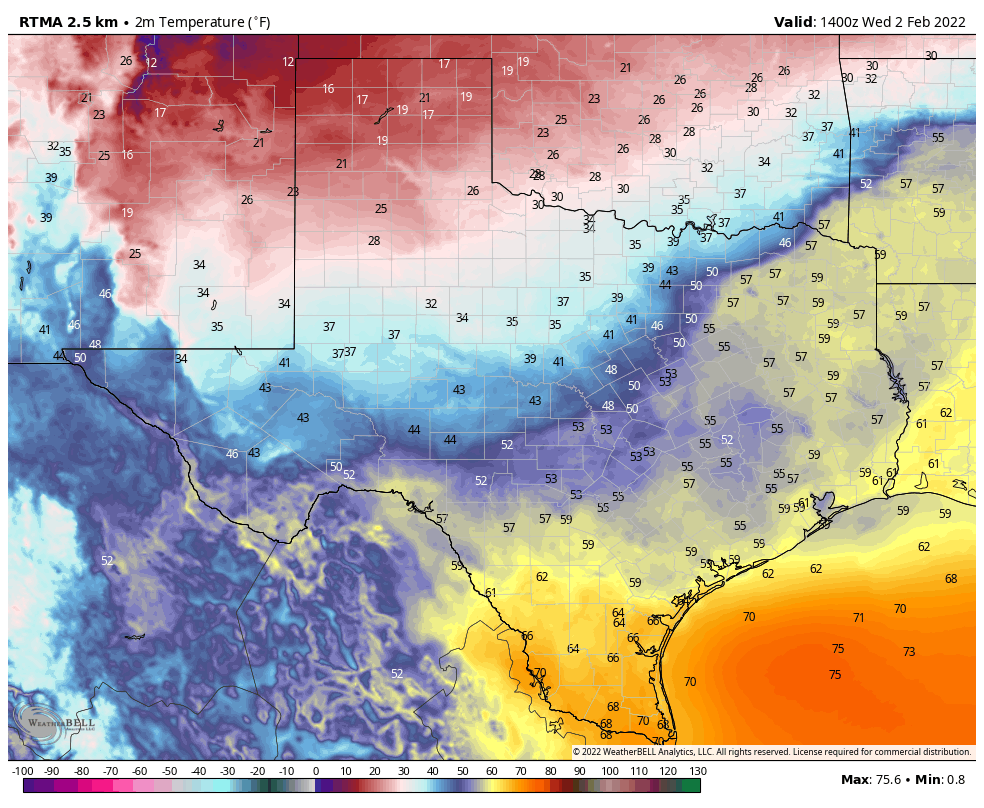 MAJOR WINTER STORM TO IMPACT THE REGION - As advertised for the past few days, a significant winter storm bringing copious amounts of ice, sleet, and snow is making its' way toward the North Texas region as we speak. *A Winter Storm Warning is in place for ALL of the North Texas region. *The Winter Storm Warning in place for the I-20/287 corridor to the north west of the metroplex goes into effect at 3p today. *The Winter Storm Warning which includes the DFW Metroplex, points to the northeast, and southwest goes into effect at 6p today. *The Winter Storm Warning which includes all areas to the south of the aforementioned municipalities goes into effect at midnight. 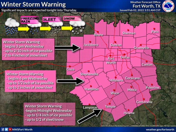 FORECAST UPDATES - As previously mentioned, the cold front is already has already moved through the metroplex, which is a couple of hours ahead of the middle range forecast guidance. This will lead to a higher-end winter weather event. As such, I must adjust the accumulation forecast and timing to compensate for this change.
EARLY WEDNESDAY AFTERNOON - I now expect freezing rain and/or sleet to begin in Montague, Young, and Jack counties as early as 10-11a this morning. For the rest of us, temperatures will continue to fall throughout the day as moderate to heavy rain approaches from the west and south. WEDNESDAY EVENING INTO OVERNIGHT - As moderate to heavy rain falls, expect any pre-existing winter road treatment to dilute or get washed away. I expect most of the metroplex to fall below freezing at around 9-10p tonight. However, because of the fast approach of the front, please do note that there is potential for that to happen potentially in the 8-9p timeframe. All rain will transition to freezing rain when temperatures fall below freezing. From there, a freezing rain/sleet mix can be expected during the overnight hours for much of the metroplex. THURSDAY - While heavy freezing rain and sleet is happening for much of the metroplex at around 3:00a, heavy snow will be approaching from the west, moving to the east. Heavy snow will arrive in the western side of the metroplex at around 4:00a, making it to places such as Denton at around 5:00a. As the system continues to move to the east, I expect a full transition from mostly freezing rain/sleet to moderate to heavy snow for most of the metroplex by 10am, lasting for a few hours. All winter precipitation should be out of the region by late afternoon. ICE ACCUMULATION - A significant ice storm will take place tonight for most of the region, including the metroplex. The northwestern counties will see tad lower ice accumulations than previously forecast due to colder air coming faster than forecast. Most communities to the north of I-20 will see 0.25"-0.5" or greater of ice accumulation. This will make travel extremely difficult for most of the area, including making some roads impossible to travel on. In addition, some power outages and tree damage is likely. SLEET/SNOW ACCUMULATION - Snow will begin in the NW parts of the region, slowing moving east towards the metroplex beginning early Thursday morning, lasting through late Thursday afternoon. For the immediate metroplex, I expect 1-3 inches of sleet/snow accumulation. For those to the NW of the metroplex, higher totals of 2-4" can be expected. TEMPERATURES - Temperatures will fall into the single digits/teens Thursday through Saturday mornings. In addition, temperatures will NOT reach above freezing until Saturday afternoon. Aside from that, Thursday will feature temperatures only reaching the teens into the lower 20s. However, it will feel much colder with a brisk north wind of 15-20mph, gusting to 25mph at times. Wind chills will only reach the single digits throughout the day on Thursday. Many locations will report sub-zero or below temperatures by Friday morning. The actual air temperature will remain in the low 20s throughout the day on Friday. Almost all locations in the metroplex will report below zero wind chills Saturday morning, and most locations will NOT reach above freezing Saturday. Slow melting may occur on Sunday, as temperatures reach sub-freezing by the afternoon. IMPACTS - Please keep in mind that these amounts mentioned in this blog entry are significant and is more than enough to cause disruptions to infrastructure, as well as causing difficult to near impossible travel conditions with some roadways being impossible to travel on. Power outages are likely where ice buildup is on trees and powerlines. Additionally, dangerously cold temperatures are expected in wake of the winter storm for the proceeding days. Appropriate action must be taken to mitigate frostbite and hypothermia. PREPARATIONS SHOULD BE RUSH TO COMPLETION THIS MORNING AND EARLY AFTERNOON. *Be sure all of your phones, tablets, and other devices are fully charged. *Travel is highly discouraged Thursday, Friday, and maybe even Saturday morning. If you MUST travel, create an emergency supply kit for your car. Include jumper cables, sand, a flashlight, warm clothes, blankets, bottled water and non-perishable snacks. Keep a full tank of gas. Have cat litter or sand to help tires get traction, or road salt to melt ice. *Gather supplies in case you need to stay home for several days without power. Keep in mind each person’s specific needs, including medication. Remember the needs of your pets. Have extra batteries for radios and flashlights. *Turn your refrigerator and freezer to their coldest settings. *If you lose power and you plug a generator into the house electrical system, turn the main off in the breaker box. Otherwise it can be very dangerous for the crews working to restore power. *Understand some could be without power for more than 24 hours with very cold, sub-freezing temperatures. Have an alternative source of heat. And, use it safely. WILL THIS BE LIKE FEBRUARY 2021? - That is a bad question. The answer is no. What happened on February 2021 was a generational winter event affect all of Texas, with the coldest temperatures observed in literal decades. We only have storms like that once every 30-40 years. What I will say is that the IMPACTS will be much higher than last year due to having more ice on roadways, power lines, and trees. Power outages may occur from downed trees and power lines from ice, not from high power demand. BE INFORMED: I know I have many first-time readers here. So I would like to say welcome and thank you for taking the time to read my products! I will have many more as we get closer to this event. If you would like frequent weather updates from me, please follow my Twitter @donowx. Please also like our Facebook page linked here. Also, please join our text messaging system to receive daily forecasts and updates by texting @apexstorm to '81010'. Or click the link. Thank you, Donovan Neal Owner - ApexStorm |
Archives
March 2023
Categories |
 RSS Feed
