
|
CLOUDY DAY - We begin the day with mostly cloudy skies region wide with temperatures in the low to mid 50s with some isolated cooler spots. 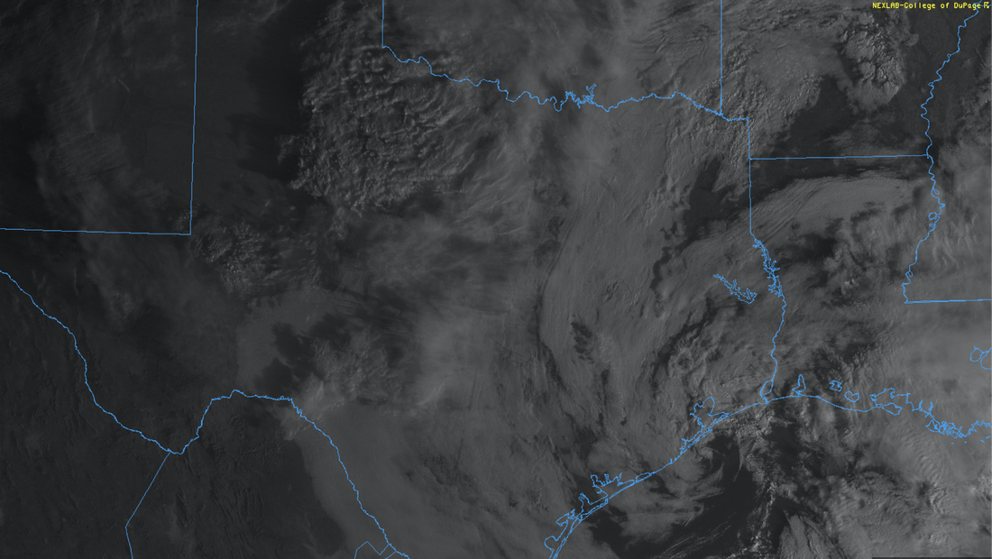 Expect temperatures to be in the middle to upper 60s this afternoon under a mostly cloudy sky. WINTER STORM EXPECTED WEDNESDAY EVENING INTO THURSDAY - A potent arctic cold front combined with a deep upper air trough will bring a winter storm across the central two thirds of the CONUS and much of the North Texas region. This will come in the form of freezing rain, sleet, and even snow. Our best chances of this will be Wednesday evening into Thursday afternoon. DISCLAIMER - THIS FORECAST CAN AND WILL CHANGE WITHIN THE NEXT 24-48 HOURS. I HIGHLY URGE ALL OF YOU TO ONLY USE THE MOST RELEVANT AND FRESH INFORMATION AVAILABLE. IF YOU ARE READING INFORMATION THAT IS AT LEAST HALF A DAY OLD, YOU ARE WORKING WITH BAD INFORMATION. TODAY WILL BE THE LAST GOOD DAY TO PREPARE BEFORE THE INITIAL ONSET OF THE UPCOMING WINTER STORM. WEDNESDAY MORNING AND AFTERNOON - Under a mostly cloudy sky, temperatures will be in the middle to upper 50s in the morning. Upon the arrival of the arctic cold front, temperatures in the metroplex will slowly begin to fall at around lunchtime. In addition, scattered to increasingly widespread showers and thunderstorms will increase throughout the afternoon. The highest chance of heavy rain will be along the I-35 corridor and points to the east. QPF totals will range from 0.5"-1". This will allow any pre-existing winter road treatment to dilute as we progress through the afternoon and evening. WEDNESDAY EVENING INTO EARLY THURSDAY MORNING - Conditions will rapidly deteriorate once temperatures reach below freezing, which will happen from northwest to southeast during the evening. Global models hold off temperatures reaching below freezing until midnight. However, due to the warm bias of these outputs, I fully expect the metroplex to be below freezing by 7 or 8pm. Keep in mind that the arrival of freezing temperatures may arrive earlier or later than the given time by an hour. All rain will transition to freezing rain once temperatures reach below freezing, thus beginning ice accumulation. Then, freezing rain will transition into sleet shortly after the onset of freezing rain. The freezing rain/sleet mix will last all through the night into the morning hours on Thursday. THURSDAY - A wintery mix of sleet and freezing rain will be ongoing for most of the metroplex during the predawn hours. A transition to moderate to heavy snow is likely from west to east, starting at around 8am, lasting for a few hours. Wintery precipitation will diminish through the late afternoon as the trough rotates out of the area, though flurries will still be possible. DANGEROUSLY COLD TEMPERATURES EXPECTED - Below freezing temperatures is expected for the entire metroplex tomorrow evening, lasting through Saturday. That means any precipitation that falls will freeze and remain frozen until we get above freezing for an extended period of time. Aside from that, Thursday will feature temperatures only reaching the teens into the lower 20s. However, it will feel much colder with a brisk north wind of 15-20mph, gusting to 25mph at times. Wind chills will only reach the single digits throughout the day on Thursday. Many locations will report sub-zero or below temperatures by Friday morning. The actual air temperature will remain in the low 20s throughout the day on Friday. Almost all locations in the metroplex will report below zero wind chills Saturday morning, and most locations will NOT reach above freezing Saturday. Slow melting may occur on Sunday, as temperatures reach sub-freezing by the afternoon. IMPACTS - Current thinking is that this will be mainly a freezing rain/sleet event across the metroplex. Areas to the northwest and the metroplex will see 0.5"-1.0" of freezing rain. The highest sleet accumulations will be from the metroplex and northwest, ranging from 0.75" - 1.50" with the possibility of thundersleet. The highest coverage of snow will be in the metroplex and points to the north and weset, where 1-3" will be possible. For DFW, anywhere from a dusting to up to two inches can be expected. Please keep in mind that these amounts are significant and is more than enough to cause disruptions to infrastructure, as well as causing difficult travel conditions with some roadways being impossible to travel on. Power outages are likely where ice buildup is on trees and powerlines. Additionally, dangerously cold temperatures are expected in wake of the winter storm for the proceeding days. Appropriate action must be taken to mitigate frostbite and hypothermia. I fully expect a Winter Storm Warning to be issued for most of North Texas later tonight or sometime tomorrow. PREPARE - Use today to prepare as much as you can around the house... TODAY IS THE LAST GOOD DAY TO PREPARE FOR THIS EVENT. *Be sure all of your phones, tablets, and other devices are fully charged. *Travel is highly discouraged Thursday, Friday, and maybe even Saturday. If you MUST travel, create an emergency supply kit for your car. Include jumper cables, sand, a flashlight, warm clothes, blankets, bottled water and non-perishable snacks. Keep a full tank of gas. Have cat litter or sand to help tires get traction, or road salt to melt ice. *Gather supplies in case you need to stay home for several days without power. Keep in mind each person’s specific needs, including medication. Remember the needs of your pets. Have extra batteries for radios and flashlights. *Turn your refrigerator and freezer to their coldest settings. *If you lose power and you plug a generator into the house electrical system, turn the main off in the breaker box. Otherwise it can be very dangerous for the crews working to restore power. *Understand some could be without power for more than 24 hours with very cold, sub-freezing temperatures. Have an alternative source of heat. And, use it safely. CRAP APPS: All throughout the day yesterday, I have received literally several notes and comments from my professors and colleagues telling me what their weather app is showing. Look, I understand the convenience of the app that is preinstalled on most smartphones. It is insanely convenient! you open it, you are shown a symbol with the high temperature, a low temperature, and a chance of precipitation. In a complex, active winter pattern such as this one, automated apps and websites are pretty much useless 2-3 days in advance (sometimes 24 hours). They use computer model data which can be absolutely horribly inaccurate in a time like this. They do not provide ANY context, and, most importantly, does not communicate uncertainty at all when forecasting. There is going to be range of possibilities and it takes a little more than a glance at an app on a phone to understand the complex weather pattern that we are in. So, I would use great caution while you are looking at an app, and I will leave it at that. :-) MAP LITERACY - Just about anytime we forecast extreme weather, I get dozens of messages that consist of "what about *insert town or city here*". Most of these messages come on posts with references to counties or major highways in North Texas. In my five years of doing this, I have learned that several people struggle with geography, and more specifically have a tough time trying to read maps. I understand. I struggle with many things to. If you were to give me analytic geometry questions, I would look at you like you just shot a man before my eyes. But there is no way we can name hundreds of municipalities in North Texas on every post. I encourage you to take a few minutes to learn the major highways and counties relative to your location. I promise it will help you understand the blog entries and the posts I make here addressing any time of weather extreme. 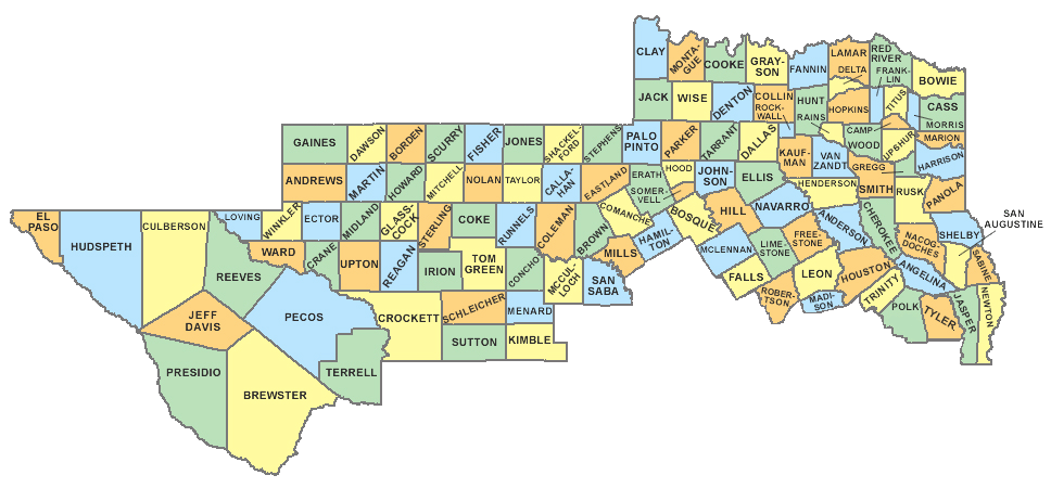 BE INFORMED: I know I have many first-time readers here. So I would like to say welcome and thank you for taking the time to read my products! I will have many more as we get closer to this event. If you would like frequent weather updates from me, please follow my Twitter @donowx. Please also like our Facebook page linked here. Also, please join our text messaging system to receive daily forecasts and updates by texting @apexstorm to '81010'. Or click the link.
Thank you, Donovan Neal Owner - ApexStorm |
Archives
March 2023
Categories |
 RSS Feed
