
|
The same principle for winter weather forecasting applies to severe weather forecasting. Before high-end weather events such as this one, it is important that you are reading fresh information. If you are reading products that are 10-12 hours old, you are working with bad information. This blog update was released at 3:54 PM CDT on Tuesday, March 16. DANGEROUS ST. PATRICKS DAY SEVERE WEATHER OUTBREAK TOMORROW - Let me preface this blog entry by saying that this is the most serious threat of severe weather the Deep South has had since April 28, 2014. We saw what transpired in the Texas Panhandle a few days ago and knew that a major severe weather episode was not too far from us. And now, here we are. The Storm Prediction Center (SPC) has a Moderate Risk (4/5) of severe weather for much of Central Alabama, Mississippi, and parts of Louisiana, Arkansas, and Tennessee. The rest of the categorical spectrum follows for the rest of the subsequent areas on the map. 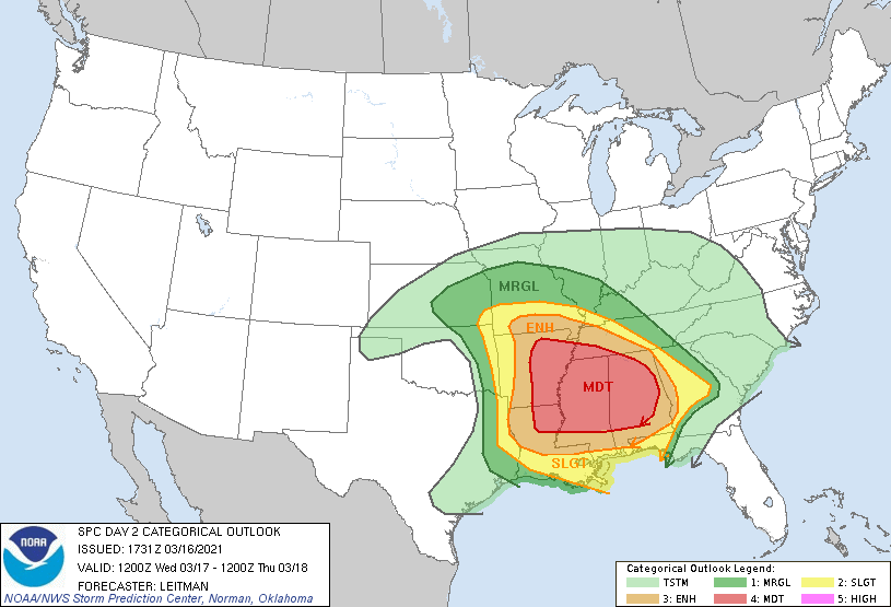 Before I proceed further. I encourage you to not get hung up on the exact placement or names of these risks. Storms do not follow these colorful guidelines and have no idea where they are. It ultimately does not matter whether the SPC issues a High Risk tomorrow. Some red letter severe weather days happen to fall on moderate risk days. The point is that everyone that is in the Enhanced Risk and higher need to pay special attention to the weather over the next 48 hours, and craft a plan for different scenarios.
SYNOPSIS - A negative tilt upper trough with high wind gradients will spin up an upper low over Arkansas. Warm, moist, unstable air will already be covering most of the region. The mid-level jet will become coupled with the low-level jet by the afternoon and evening hours tomorrow, especially after sunset, creating a favorable combination of lift, shear, and helicity for potentially strong tornadoes and very large hail, and damaging winds. The greatest probabilities for a regional episode of tornadoes is forecast in the moderate risk area. Yes, that means there is a threat for strong/violent, long track tornadoes even after dark. In addition to the tornado risk, very large to giant sized (golf ball sized or larger) hail and wind damage will like be likely across a large part of Arkansas, Mississippi, Northern Louisiana, and Western Tennessee tomorrow afternoon and evening.. The threat for damaging winds is expected to increase as a mesoscale convective system (MCS) moves eastward across the entire region Thursday morning, signaling the end of the threat for severe weather by daybreak for Mississippi and Alabama. TIMING - Thunderstorms are likely tomorrow morning for the northern quarter of the aforementioned region along a northerly moving front. Some of those storms could be strong. The severe weather risk associated with that looks very low, however, on days like this, we will have to closely monitor. Afternoon storms will begin to develop to the west by at least 2PM, where they will be scattered in nature. Any storm that develops at this time could quickly turn severe. The peak for discrete supercell thunderstorms for Mississippi and Alabama will come from around 3PM to 3AM. The more organized activity will come well after midnight. THREATS - ALL modes of severe weather will be possible, including the threat for damaging winds and VERY large hail. Several tornadoes are expected, including the possibility for violent long-tracked tornadoes even after dark in many places. UNCERTAINTY - With any severe weather event, comes with the air of uncertainty that could either make for a worse-case scenario or for storms to not be as intense, which is ultimately what we want. Elevated convection within the warm sector is expected during the morning hours, which could dampen the overall severe potential, or produce enough outflow to introduce a higher-end tornado potential. In addition, it is unknown how quick or sharp the cold front will end up being, which can make the difference between several discrete supercells or only a few stronger discrete cells with a lot of clusters in between. This type of uncertainty precludes the need to upgrade to a high risk with this forecast at this present time. However, a High Risk is probable sometime tomorrow due to the potential for a high-end life threatening event across the Deep South. WiLl tHiS bE LiKE aPRiL 27tH, 2011?: I really do not like this question at all. 216 tornadoes were confirmed that day, with a third of them being strong to violent. Those are generational events. Meaning, they tend to happen once every 40 years or more. However, bear in mind that if there is only one tornado in your state, and that happens to come down your street, that is YOUR April 27th, 2011. PREPARE, PREPARE, PREPARE: Today is day where you and your family need to keep ready for severe thunderstorms. Be sure you have multiple ways of receiving warnings. NEVER RELY ON A TORNADO SIREN. First, make sure you have a NOAA Weather Radio. Every home in the Deep South needs one as they work off of their own network, making them very reliable. On your phone, make sure you have WEA (Wireless Emergency Alerts) enabled on your phone. To make sure of this go to Settings > Notifications > scroll all the way down to the bottom to ensure that "Emergency Alerts" are enabled. Find the safest place in your home. It is typically in a small room, on the lowest floor, near the center of your house, away from windows. In that safe place, have helmets for everyone, airhorns (in case you are injured and need to alert first responders on site), and hard-sole shoes (if you must walk over tornado debris). If you live in a mobile home, you can not stay put during a tornado warning. Identify the nearest location of a shelter or safe place, and know how to get there at a moments notice. MAP LITERACY - Just about anytime we forecast extreme weather, we get dozens of messages that consist of "what about *insert town or city here*". Most of these messages come on posts with references to counties or major highways. In my five years of doing this, I have learned that several people struggle with geography, and more specifically have a tough time trying to read maps. I understand. I struggle with many things to. If you were to give me analytic geometry questions, I would look at you like you just shot a man before my eyes. But there is no way we can name hundreds of municipalities on every post. I encourage you to take a few minutes to learn the major highways and counties relative to your location. I promise it will help you understand the blog entries and the posts I make here addressing any time of weather extreme. YOU'RE GONNA BE FINE: I am well aware that we are in a time in our society that most people in the South, and nationwide, are suffering from high anxiety from a global pandemic and civil tensions. The last thing we want as trusted forecasters is to add to that anxiety. However, at the same time, we must present the weather situation the way it currently stands. I understand we have many people across the south who have a literal phobia of thunderstorms and tornadoes. If you are located anywhere in the Deep South, just know that there is no reason to panic about tomorrow. Even during a severe weather outbreak, the chances of a tornado hitting your house are low, as tornadoes are tiny compared to counties, or the entire state. Unfortunately, lots of amateur weather weenies are on the social media outlets today using a myriad of scare tactics, which is ridiculous and irresponsible. They do not have any prior knowledge behind the different models and maps, what they mean, or how to interpret it. Yet, people will share them without second guessing. Please stay away from these pages, as nobody needs more anxiety. Only get weather information from trusted sources (like this blog and our social media outlets). Donovan Neal Owner - ApexStorm |
Archives
March 2023
Categories |
 RSS Feed
