
|
COOL/CALM - Temperatures are in the mid to upper 40s this morning across the region. We will likely see these drop a degree or two in the next hour or so, but the sky will become mostly sunny with afternoon highs in the mid 70s. Friday - For most, the daytime should be dry with highs in the mid 80s by the afternoon. We will mention the chance of a random showers during the day. A strong cold front will push from the north during the evening, and scattered thunderstorms will accompany it. Some of those storms could turn quite severe with potential for all modes of severe weather. The Storm Prediction Center maintains the standard "slight" risk of severe storms for the DFW Metro and points to the east and south. 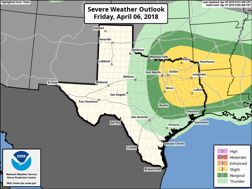 THREATS - As previously stated above, all modes of severe weather will be possible. The damaging wind threat will stay relevant to any storms that can stay along the cold front and remain in a cluster. The more discrete supercells will have the potential to rotate, producing large hail at times and a few tornadoes. Uncertainty regarding storm initiation ahead of the cold front precludes the risk for a more significant severe weather event. The more intense storms might stay to the southeast of DFW, where energy helicity is maximized. TIMING - A few showers will be possible during the day, then a strong cold front comes through at around 7-9pm, bringing severe weather on the backside of the front. Of course, we will still mention the potential for a few storms to develop ahead of the main front, so the peak hours for storms in DFW are around 6-10PM. Areas to the southeast - 7pm-12AM. We will continue to keep you updated as new information comes out. GROWERS BEWARE - As the cold front comes through, cold air advection will follow, which will make Saturday morning feel like winter to some extent. We will mostly be in the mid to upper 30s around sub-freezing temperatures, though some of the naturally cooler spots could see a light freeze in some places. A chance of a wintery mix exists later in the morning for some parts of Oklahoma and west Texas. After the morning, we will turn dry, but highs will only reach the mid 50s. We turn sunny again on Sunday with highs in the mid 50s NEXT WEEK - A great chunk of next week remains dry with a mix of sun and clouds with highs in the 70 degree range. After Saturday, we could be done with freezes for the rest of the season. See the Texas Weather Discussion Video for more details. 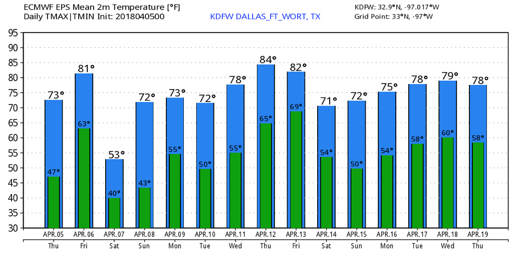 |
Archives
March 2023
Categories |
 RSS Feed
