
 END OF THE METEOROLOGICAL SUMMER:
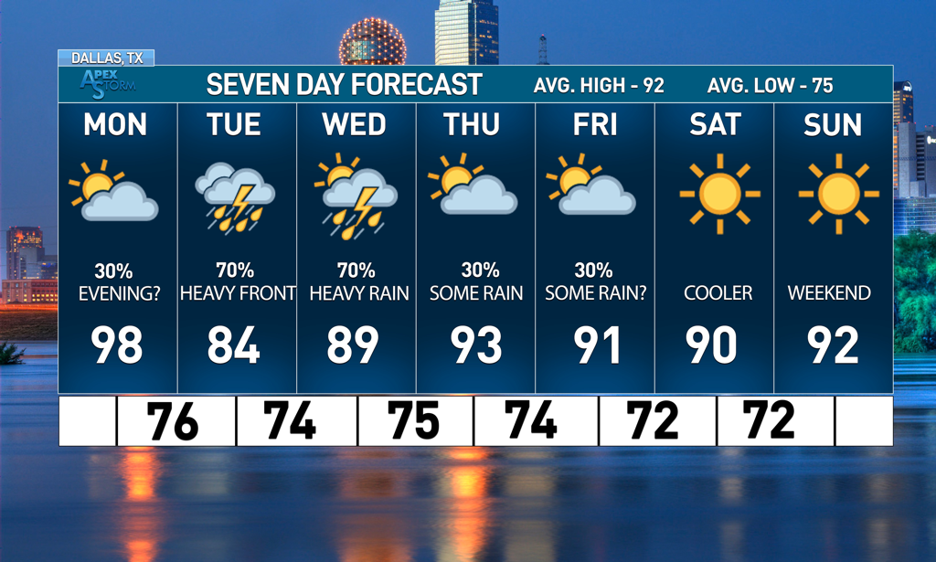
After a relatively lackluster August, the weather decided to end meteorological summer with a bang. Saturday was an exclamation of every phenomenon we’ve been experiencing—a record breaking day of heat for DFW with heat indices upwards of 115 degrees that culminated in an over-performing cluster of storms all across North Texas, mirroring the scattered thunderstorms simultaneously popping up all across Oklahoma and Arkansas. All of the rain yesterday came at the hands of a weaker shortwave—with another front looming on the horizon, what does this indicate for North Texas next week? MONDAY SHORTWAVES: Sunday continued to be relatively precipitation free, with low chances in the evening as typical destabilization occurs (although, formation of any storms would be extremely limited as the complex of storms that moved throughout the region yesterday ate up most of the moisture). Temperatures will continue to be hot with the potential for Dallas to get to triple digits again Monday. However, during the day Monday, two westerly shortwaves are projected to move in, bringing with it the chance for more severe storms. Coverage for the storms is supposed to be greater and stronger among Southern Oklahoma and along the red river in the middle of the day, but as the day progresses, parts of North Texas could be subject to severe thunderstorms if the timing of the storms allow. Storms could be accompanied by strong winds of up to 60 mph and there is a low, but nonzero risk of small hail. DFW has been placed just south of the slight risk area but that could change as the day continues. TUESDAY FRONT: A large front is scheduled to move into North Texas on Tuesday afternoon that will also bring considerable rain and severe storm chances. Localized amounts of 2-4 inches are possible between the Red River and the northern part of the metroplex, with the severe chance moving southeast as the day progresses. There is a threat for severe storms capable of producing hail and damaging winds, similar to Monday. A moderate risk is in effect for much of North Texas for Tuesday and it’s possible that all of the metroplex is upgraded to slight eventually as there is a strong large-scale ascent. Highs are projected to be in the 80s and there aren’t any chances for tornadoes at this point in time, however, I would urge anyone to continue to stay updated with their local weather affiliates and the NWS/SPC to stay weather aware. THE REST OF THE WEEK: Rainfall chances continue to exist throughout the week, with heavy rainfall forecasted for Wednesday as the shortwave moves out of Texas. Models currently indicate the potential for flash flooding as we see localized pockets of heavy rain around North Texas. Small chances of rain exist for Friday as well if the storms reach far enough south. In good news, however, temperatures will remain much lower throughout the rest of the week following the front, with highs in the upper 80s and lower 90s for the foreseeable future. It will be a welcome break from the onslaught of heat from the last few days. There is even talk of a further cold front after labor day weekend, though it is entirely too far out to legitimize anything. Stay dry, stay cool, and stay weather aware! -Colin Welty |
Archives
March 2023
Categories |
 RSS Feed
