
|
Hello everyone! We have a busy meteorological week approaching North Texas with many variables that could range from typical fall days to potential winter weather. There are a lot of potential outcomes that could take place and I’ll be discussing them in this blog update! WEEKEND UPDATE: A relatively mild weekend has been in play for much of North Texas, with highs in the upper 50s for Saturday and approaching the mid 70s for Sunday. It’ll be an absolutely gorgeous weekend for everyone to spend outside and take advantage of before the real fun begins on Monday. 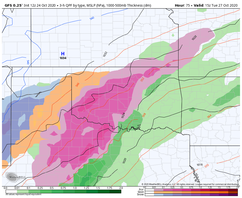 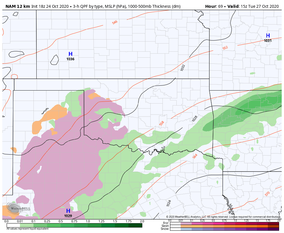 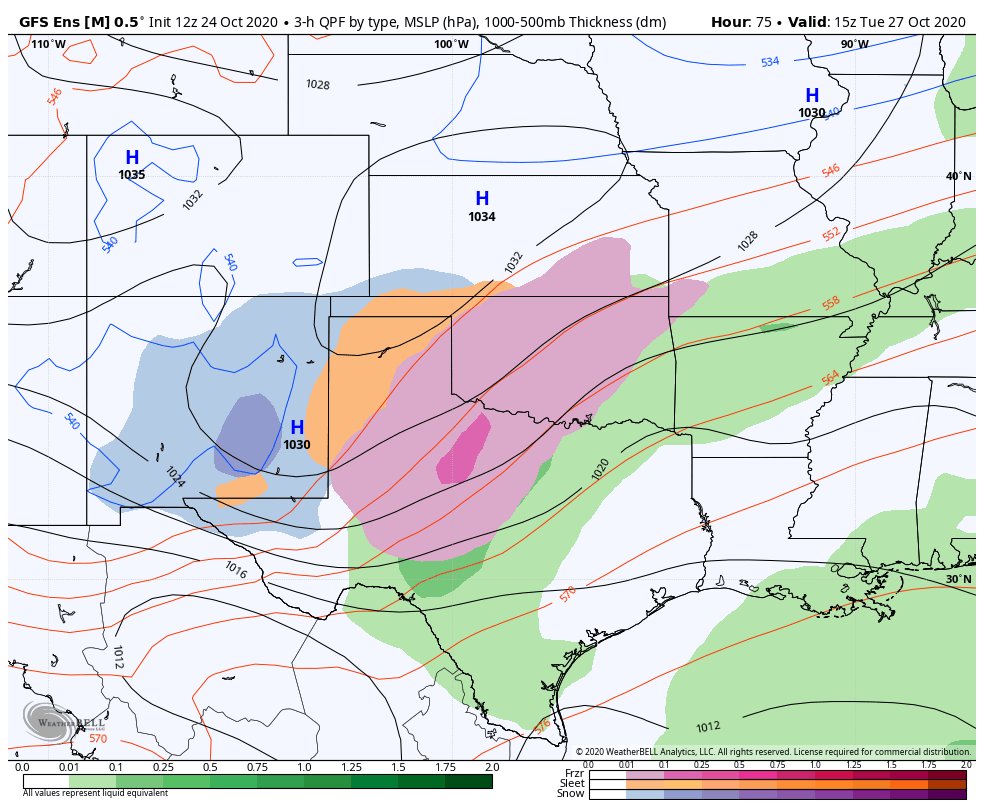 COLD RAIN CAPITAL OF THE WORLD:
As rain moves in overnight Sunday, it’ll be a glimpse of the week ahead for North Texas. Rain will be widespread as a result of a low pressure system with convergence tapping into gulf moisture, keeping temperatures in the 50s for most of the region. However, a high pressure arctic front will move in overnight Monday and will significantly drop temperatures and close off the low pressure system, providing us with plenty of moisture to tap into. While there had been about a weeks worth of models entertaining a potential freeze for DFW and other areas, with sleet and freezing rain looking likely, short range models have now started to roll back the strength of the front. There is considerable disagreement between the ensemble models, who show frontogensis with freezing rain and sleet, and the short range models who are running 5 degrees warmer, making it more and more likely that most of North Texas will see a cold rain on Tuesday and Wednesday with lows in the low 40s to upper 30s. Wind chills are forecasted to be in the low 30s Wednesday morning, which means it’s definitely time to use that winter coat! Parts of the panhandle and WTX are likely to see snow and ice and it’s possible certain parts of NTX see some sleet or freezing rain as well. Oklahoma, especially the panhandle and Western Oklahoma, could also see some significant ice with some models showing up to an inch of accumulation from a freezing rain and sleet mix. However, I am siding with the guidance of the NAM, as it has been the king of winter storms the past few winters, especially given the Euro’s inability to handle certain arctic fronts and the GFS’s inherent cold bias. The addition of a TD in the gulf is further complicating the situation as the influence of that low could force the low across texas to close off further south, allowing the high pressure air mass to travel further south as well, but it’s too early to know how that will play out. So, while a winter wonderland is not entirely off the table, it’s looking likely that North Texas will maintain its standing as the cold rain capital of the world with multiple days of cold rain. While no one should expect to see anything wintry this week, If you see any sort of winter precipitation make sure to tag us in your photos and use #ApexStorm! WHAT DOES THE FUTURE HOLD? After Wednesday, the moisture is set to clear out with pretty mild temperatures occurring throughout the following days. The highs will creep up into the high 60s by the weekend, with clear skies for Halloween night on Saturday! Not too many chances for precipitation in the near future, but there won’t be any record breaking heat either. Keep your eyes out for this upcoming cold front as even 2 degrees colder could massively change the game for winter precipitation. Models have a tendency to underperform, as shown by the cold front Friday morning, and the complicated setup with both arctic air and tropical storms potentially interacting makes this particular forecast extremely difficult to accurately predict, so make sure to stay aware of what could happen in your area. Stay dry, stay warm, and stay weather aware! -Colin Welty |
Archives
March 2023
Categories |
 RSS Feed
