
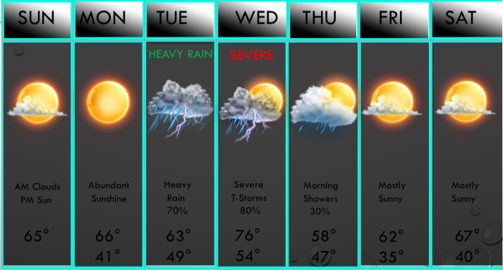
 Above is your UPDATED seven day forecast, and I've removed mention of isolated storms tomorrow, as all rain will be confined to our far southeastern counties tomorrow. Cloudy skies and fog will be the headlines in the morning, but areas WEST of I/35 will break out into abundant sunshine, but areas east of I/35 may be blanketed under the clouds for most of the day. Highs tomorrow in DFW will be in the 60s, with 70s west of DFW and 50s east of DFW. I expect DFW to see some sun by afternoon, but if the sunshine struggles to come out, we may stay in the 50s. My forecast high is 65° and I think that high temperatures will suffice. Some more sunshine is expected Monday, but a few spotty storms return late Monday Night into Tuesday morning, but widespread rain, and possibly even some thunderstorms, are expected by late afternoon Tuesday. Meager instability will limit the threat of severe weather during the afternoon, but a strong storm with small hail and gusty winds is possible mainly south of D/FW. Storms will exit the region Tuesday night with a break overnight into Wednesday morning. By midday Wednesday, a cold front and dryline will approach our western counties, possibly firing up some scattered supercellular thunderstorms, with severe storms possible with sufficient instability and very strong shear. With the strong shear, damaging winds and potentially tornadoes will likely be the main severe threats, but with impressive lapse rates, some large hail to the size of tennis balls may be possible during the afternoon. While this doesn't look to be a tornado outbreak, a few tornadoes are possible, and we will closely monitor this threat the next few days. Scattered to widespread severe storms will push from west to east during the afternoon, but then a cold front will bring in a damaging wind threat as a squall line of storms develops. Lingering rain and rumbles of thunder are likely Thursday morning, then we dry out and we will be 10-20° cooler Thursday compared to Wednesday. Warmer weather moves back in next weekend, with maybe a small chance of a thunderstorm next Sunday mainly E of D/FW. Some relatively cooler air (50s for highs) will return next week.
WINTER WEATHER: We have a chance of seeing some colder air in March, but the pattern doesn't look to completely support snow or ice chances. But, any disturbances near the Sea of Japan may bring chances of wintery weather, and if a high pressure system can develop over Florida, moisture will have to wrap around the upper level high and will force moisture back into North Texas. Obviously if this happens and we have cold air, we could squeeze out some light wintery precipitation, even with little to no lift. But, if this doesn't occur but we do have a system, we may possibly have some very light wintery precipitation. If all three of these factors can come together, than we may have a winter storm to deal with. Again, this cold air will likely be in place during the first FULL week of March. The overall risk of us seeing any winter weather appears LOW in my opinion, but there is indeed at least a chance of seeing winter weather before we enter Spring. -Jonathan Williams The storms from this morning have finally pushed east of the metroplex with some minor damage done from these storms. We've had lots of flooding reports, but we've received hail reports, up to the size of quarters, shattering skylights in parts of the metroplex, and some 40-60mph wind gusts, but no damage has been reported from winds. And yes, the sun is peaking out. Some sunshine is expected this afternoon, but an isolated thunderstorm or two, possibly severe, may develop this afternoon and may pose a large hail threat mainly east of I/35. The tornado risk increases this evening in Arkansas to Louisiana to Tennessee as well as a very large hail and damaging wind threat. We will finally have 48 hours of dry time and sunshine, but some clouds may move back in by Monday. The NAM 3k has some scattered showers developing tomorrow afternoon, but will leave it out of the forecast for now because it's the only model showing this. I may insert a 20% chance of showers tomorrow in this evenings seven day, and I also apologize for the inconvience that the 7 day hasn't been updated in a few days. I will update it this evening and I expect to return to the normal schedule by tonight. Anyways, Monday will be a dry day with some mid level clouds moving in during the afternoon ahead of our next storm system. Some elevated shower activity may develop in our far eastern counties Monday afternoon with the increase in moisture content, but DFW will remain dry. Tuesday will be a stormy day, primarily during the afternoon. Widespread clouds and patchy drizzle and fog will be with us during the morning hours, but widespread thunderstorm activity (50-70%) will be with us during the afternoon hours. A few of these storms may turn strong to marginally severe, with quarter to half dollar size hail and gusty winds up to 60mph possible. Locally heavy rainfall may lead to flash flooding with 6-12" of rain that have fallen the past few days. Also, frequent cloud to ground lightning may also be a risk. Heading into Tuesday evening, a line of storms may have a damaging wind threat, and an embedded tornado cannot be ruled out E of DFW. By Wednesday this is when our first significant severe risk of the season may occur. Below is the DAY 5 severe weather risk issued by the SPC:  We have been outlined in a 15% risk area, which is a level 2 slight risk. I think by Wednesday morning, the entire DFW area will be under an enhanced risk of severe weather, and all modes of severe weather including very large hail, damaging winds, and tornadoes appear possible. We will closely monitor this threat of severe weather. Some scattered storms are possible (perhaps severe) Thursday morning before moving east of our region. Dry weather will return by next weekend and fairly mild temperatures will continue with highs in the mid 50s and 60s.
For the first time in a while, there are signs of wintery weather returning to the Dallas/Fort Worth area in the foreseeable future. The long range data is in agreement that the NAO (North Atlantic Oscillation) will turn negative in response to the sudden Stratospheric Warming Event that happened last week, and this will cause significantly colder air to come into the lower 48 in early March. We will watch for this active pattern that will set up, with a strong high pressure system sitting over Florida during the timeframe that may lead to pluming moisture into Texas. This would set us up for several major winter storms, so we will watch this pattern closely. SPRING OUTLOOK: We will likely have a very active spring with fairly normal temperatures across the state of Texas, and it actually appears that some cold air could even come into Texas during April according to the EPS LONG RANGE. This is a rare occurrence, and by cold I mean temperatures (highs) in the 40s. We will watch that closely. We may have a very active severe weather season, so get used to these severe risks, as we may have a bad spring coming to North Texas. As always you can follow me on twitter @wx_dfw!! -Jonathan Good evening, DFW. Jonathan williams here! I've been looking at some new data that just came in and I have much higher concerns for the Dallas/Fort Worth metroplex regarding the potential of a wintry mix expected tomorrow. The latest NAM, which thinks temperatures should be in the mid 40s now with temps in the mid 30s across most of the metroplex, has widespread freezing rain and sleet in Tarrant, Northern Dallas, Collin, and Denton Counties tomorrow morning. With temperatures running below what it thinks we are now, we may end up in the upper 20s and lower 30s in the DFW metroplex by tomorrow morning, therefore, have included a wintry mix after 10z tonight. (4AM) Accumulations with the NAM have up to 1/4" of an inch of ice tomorrow morning with some light sleet accumulations as well. The winter weather advisory has been expanded to include Denton County, and I expect it to cover the entire metroplex by tomorrow morning. Do I think this will reach Winter Storm Warning criteria? I doubt it but anything is possible seeing how crazy this winter has been. Hazardous travel is expected tomorrow morning, with a widespread rain/freezing rain mix tomorrow afternoon, possibly mixed with sleet at times. Bottom line is that confidence is increasing significantly for icy conditions. Stay tuned and I'll have updates in the morning along with your updated 7 day forecast!
-Jonathan (@wx_dfw on twitter)  Widespread heavy rain continues to fall across the Dallas/Fort Worth area, with some freezing rain, sleet, and snow falling along the Red River. Most of the metroplex at this time is in the 30s and 40s at this time, with the northern sections beginning to fall closer to freezing. Still no reports of wintery weather in the metroplex, but some winter weather is likely falling north of the metroplex. I was looking through the newest guidance, and I have increasing confidence for wintery weather, especially for Collin, Denton, and Tarrant Counties. I do believe several areas in the central and northern sections of Dallas County may also see some winter weather, but anywhere from the Downtown Dallas area to the S/SE I have low confidence of any wintery weather falling in those locations. Here's my latest thinking:
Overnight: Widespread rain will likely continue through midnight, then I expect a brief lull from midnight through 3AM, before widespread precipitation moves back into the region. This is when my concerns go up. Widespread rain will overspread the DFW area with temperatures near 33° to 34° range. Some of this may fall as sleet and freezing rain. Tomorrow Daybreak/Commute: Widespread precipitation will continue to fall across the entire DFW metroplex. Some of this will transition to freezing rain mixed with sleet and snow across the DFW area. A few slick spots may develop, but overall road conditions should stay fairly ok, but again, some slick spots will develop on roadways with slick travel on bridges and overpasses, so exercise caution on your morning commute to work or school. This precipitation will continue through 9AM, then taper off from southwest to northeast. Tomorrow Midday: Widespread cloud cover will hold firm across the DFW area with temperatures remaining near freezing, likely near 33° or so. Any frozen precipitation will remain on surfaces and with temperatures near freezing with no sunshine, all ice and sleet/snow will remain on all surfaces. We will have a lull in precipitation, but excercise caution still on roadways and especially on bridges and overpasses. We will watch an area of enhanced precipitation to the southwest/west of the DFW that may bring a second round of winter weather to the DFW metroplex. Tomorrow Afternoon/Evening: This area of enhanced precipitation will move into the DFW metroplex near 2PM or so, with some pockets of heavy precipitation possible with a very strong and dynamic system. Temperatures will probably reach the 33° to 34° area, but precipitation will likely remain in frozen form for Collin, Denton, Tarrant, and northern Dallas Counties area points NW. Freezing rain mixed with rain, sleet, and snow will fall across the DFW area. I do believe the majority of this will be freezing rain and rain, but sleet and snow is still likely to be mixed in at times. This may accumulate on grassy surfaces. Some ice accumulation is likely, with amounts up to 1/10th of an inch. Some rain will likely mix in. IF TEMPERATURES ARE LOWER THAN EXPECTED, we may have a risk of more impactful accumulations, and more sleet and snow will be possible. IF TEMPERATURES ARE HIGHER THAN EXPECTED, than we may have mainly rain mixed with a little freezing rain with NO sleet or snow. We will keep you updated because both of these scenarios are possible. The updated seven day forecast will be uploaded to the website by 6:30AM tomorrow. I will likely increase precipitation chances from 70% to 90-100% in tomorrow mornings forecast, but I expect to keep the forecast high tomorrow of 34° in the forecast. As always I am available on twitter @wx_dfw and will answer all your questions. -Jonathan Widespread strong storms continue right now as of 4:45PM, and these will continue all evening with temperatures falling into the 30s. This is where everything becomes interesting. There have already been several reports of freezing rain in NW Denton County. This is concerning, because temperatures are falling much quicker than expected. Overnight as widespread rain continues, a widespread transition to freezing rain and some sleet is likely across the Dallas/Fort Worth area, with a more likely area NW of DFW. Some very minor ice accumulations up to a few hundredths are possible overnight, leading to slick travel tomorrow morning mainly on bridges and overpasses in DFW. This widespread frozen precip will continue (primarily DFW points NW) tomorrow morning and afternoon, with an additional 1/10th of ice, leading to hazardous travel on all surfaces tomorrow afternoon. A winter weather advisory will likely be needed for the immediate DFW metroplex.
More blogs this evening as I recieve more data. Have a great evening and enjoy the rain/storms! -Jonathan 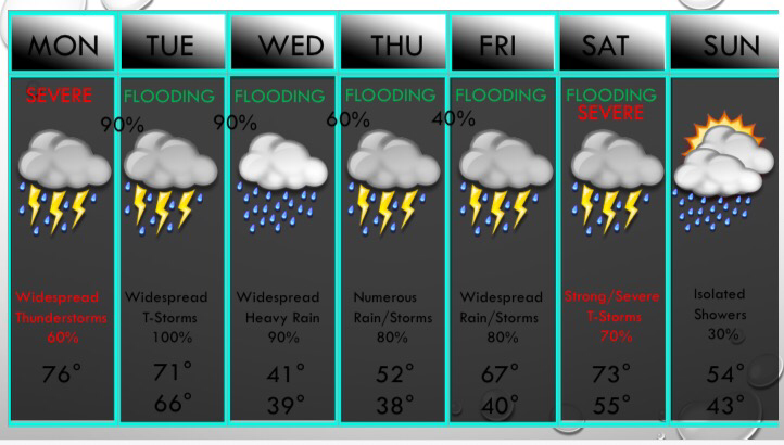 Above is the UPDATED 7 Day Forecast:
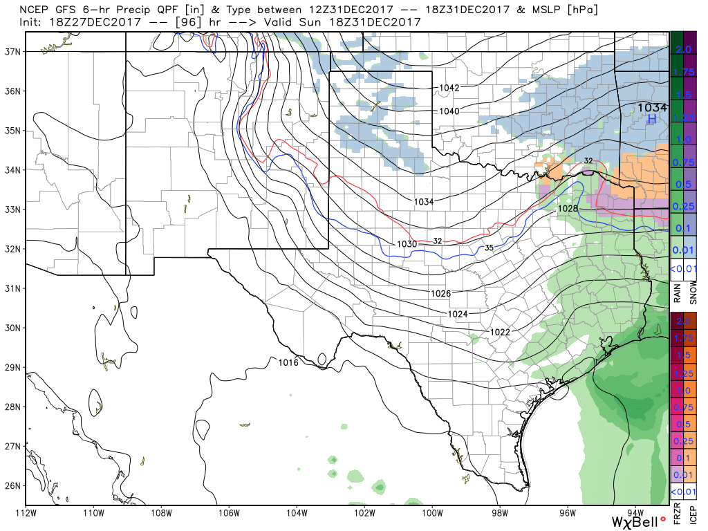
A new Update on the seven day will be posted by 5PM. Severe Potential: Spotty showers continue in DFW because the cap is still holding any thunderstorm development to a minimum. Below are my concerns and thinking for this afternoon: Severe Potential: Scattered thunderstorms are expected to develop this afternoon, with near a 40-60% coverage of storms this afternoon. This coverage may be lower or higher than this number depending on many things: It's more likely to be higher than to be lower and here's why - The cap is something that suppresses thunderstorm development and it is still holding mainly strong at this time, but is a bit weaker than I anticipated. It is expected to continue to weaken and it may approach a breaking state. The instability also is increasing and is close to 1000 jKg at this time. I've noticed a few breaks in the clouds and sunshine will help us destabilize and have a higher instability value. So bottom line is that scattered to numerous thunderstorms are expected to develop, and they may turn severe. Large hail is likely to be the highest risk this afternoon, although damaging winds cannot be ruled out. This will NOT be a significant severe weather outbreak, but a few storms may turn severe. Stay up to date and keep an eye on the radar. The next timing on concern is overnight tonight as lift increases across North Texas and a complex of strong storms moves into DFW from the west/southwest. This will pose a heavy rain threat, but hail and strong winds will also be possible with this line. Hail sizes may reach as large as half dollar, and winds may reach up to 65mph. The tornado risk with this complex is not zero, but it's fairly low. And just like this afternoon, this will NOT be a major severe weather outbreak, but a few storms may turn severe with large hail and damaging winds. More widespread showers and thunderstorms will occur through the day tomorrow, with a very low risk of severe storms. Some small hail and gusty winds will be possible along with frequent lightning, but the primary risk will be very heavy rainfall that may lead to flash flooding. More widespread rain (possibly some freezing rain well northwest/west of DFW) will occur on Wednesday. Isolated rain is possible Thursday morning, but then widespread showers are likely during the afternoon hours continuing into Friday. Some severe weather is possible next Saturday across the eastern half of North Texas, including the DFW metroplex. -Jonathan Late Afternoon Forecast Update - A Winter Weather Advisory has been expanded to include most of our counties in North Texas, with the exception of Milam, Robertson, Leon, Falls, Limestone, Freestone, Anderson, and Henderson counties. This advisory runs through midnight until noon on Sunday. 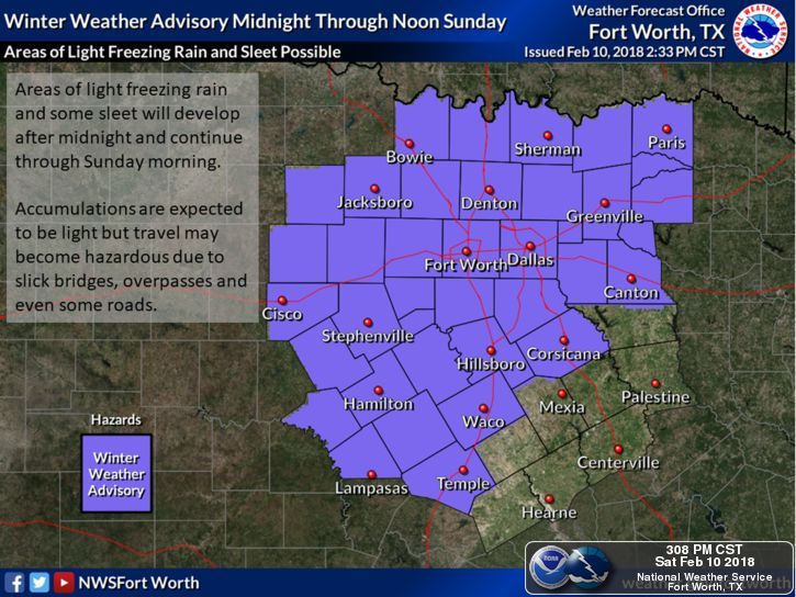 Current Conditions - Temperatures are falling to the upper 20s in most spots due to a strong cold front that came through the area this morning. It won't get any better this evening or tomorrow. 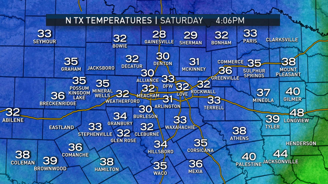 We have been cloudy all day today, and those clouds will stick this evening and Sunday.  Thankfully, we have been very dry today, and only very light amounts freezing drizzle has been observed in the DFW metro right now. However, conditions will start to deteriorate during the late overnight hours through past midnight. Here are the important notes: *Right now, I do think that the majority of the night will stay dry, but very cold. Patchy freezing rain will be possible in some places overnight, causing very light glazing on bridges and overpasses. *The system will emerge out of Mexico during the pre-dawn hours on Sunday. *Freezing rain/sleet and showers will become more likely starting from 5AM to noon on Sunday. The greatest concern is areas to the southwest of DFW, where sleet is most likely. *This will NOT be a major winter storm event, but any light amounts/accumulations of freezing rain/sleet will be sufficient for hazardous travel across the metro tomorrow. Remember, it doesn't take much to cause bridges and overpasses to be very dangerous to drive on. *Global models suggest that any precipitation will be very light, and any measurable rainfall will stay below 1/4ths of an inch. But keep in mind that any amount of rain in very cold conditions will certainly cause problems for roadways and especially bridges. *Very cold air will continue to progress from the north this evening, and temperatures will likely fall to the mid 20s tonight. *Travel conditions will not improve much Sunday evening, as many will not see above 40 during the day. *We will finally climb above freezing late Monday morning. Any leftover ice at that point will melt. I don't think it is appropriate for me to tell you whether or not to cancel any plans that you may have on Sunday. That is ultimately up to your tolerance to icy roads, but make sure that you are exercising caution when driving. Also, be sure that you are working with fresh information. If you are looking at a forecast over 6 hours old, you are using bad information. 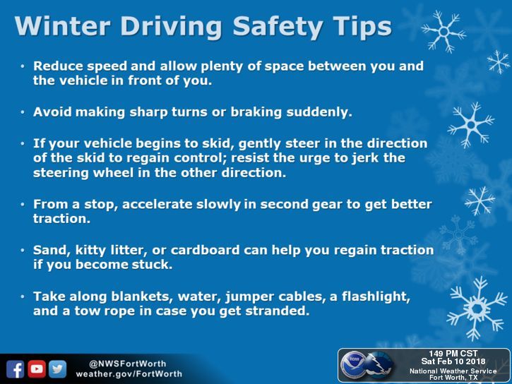 NEW YEAR'S FORECAST DISCUSSION PT. 2 - As I stated in yesterday's post, there is potential for wintery precipitation throughout the day on Sunday over the central part of North Texas, including the DFW Metro. Because moisture will be almost non-existent, accumulation, if any, will be very light. However, since this will most likely be in a arctic airmass, some travel impacts are possible. Some light snow, with some freeezing rain or perhaps sleet, will be possible for areas along and mostly north of Interstate 20 Sunday evening, and should all come to an end at around midnight as an arctic airmass pushes in from the north. Here are some of the important notes... *The ECMWF (European Global) model suggests that snow amounts of less than one inch will be possible Sunday evening. Meanwhile, the last few runs of the GFS (American Global Forecasting System) model show nothing. Since the European tends to outpreform the GFS in these situations, we wil continue to mention a chance of light showers with the chance of light snow Sunday evening. *With little to almost no moisture avaliable, keep in mind that there is always the chance that no precipitation will fall in this time frame over DFW with the exception of a few flurries, a few slow pellets, or freezing rain. *However, if the European model is correct, precipitation will be possible beginning Sunday morning in the form of light showers. When the temperatures begin to fall Sunday afternoon/evening, a wintery mix and/or light snow will be possible across North Texas. *We currently do not know if we would be on the southern or northern periphery of the system, just know that along and north of I-20 is where the greatest chances of wintery precipiation lie. Just keep in mind that it is way too early for a specific forecast, and there is no skill in trying to predict start/stop times three days out. Just use this as a heads up as to what's to potentially come, and no, do not cancel any travel plans. NEXT WEEK - We do note that there is great confidence in the coldest air thus far getting here next week. On New Year's, highs will only be in the 20s and lows in the teens. Some parts of North Texas could stay below freezing for three consecutive days. The bottom line is, plan on very cold, arctic air. keep in mind that this is posted Thursday morning @ 9:50P. Please make sure that you are using fresh, updated information as the forecast is guaranteed to change. 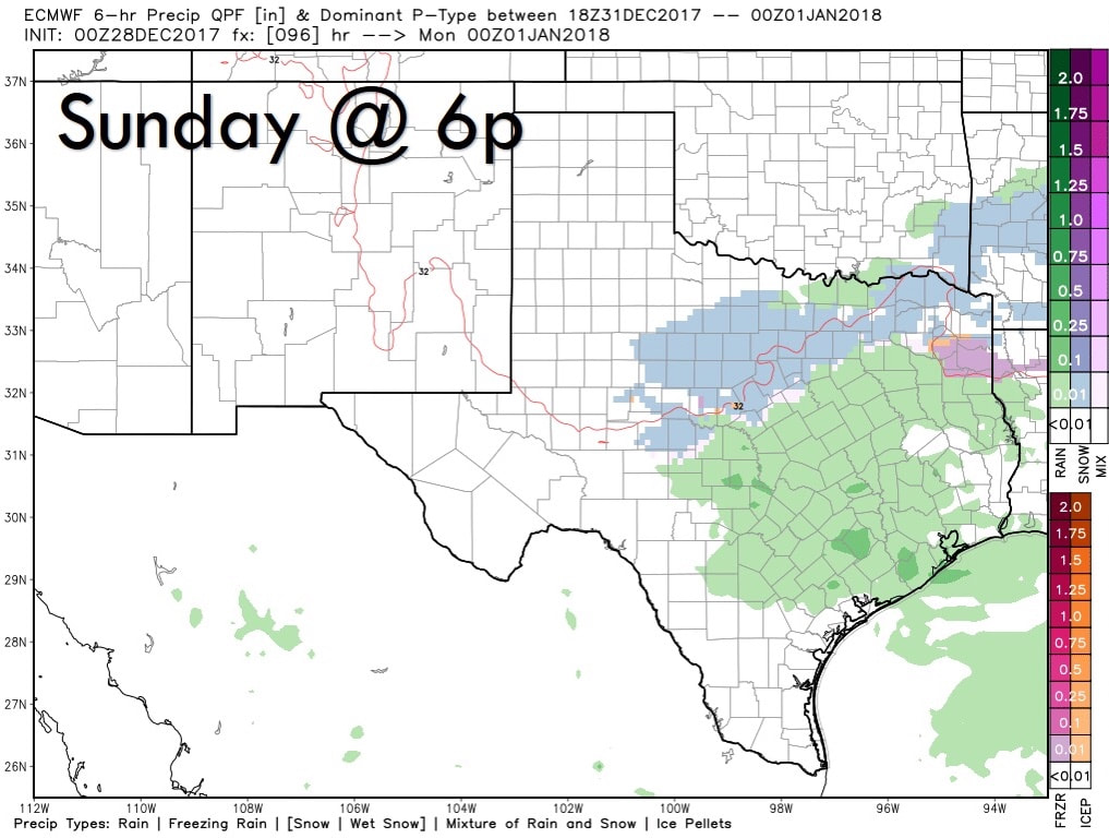 NEW YEAR'S EVE WEATHER DISCUSSION -- As we get closer towards the end of 2017, we are starting to get better model consistency which leads to more forecast confidence for this weekend. What we are certain about... - There will be another chance for scattered showers throughout New Year's Eve with the chance of some freezing rain involved (maybe some sleet pellets, but mostly freezing rain) beginning during the afternoon hours. - Very cold air sets up over much of the Continental United States afterwards, and temperatures will fall way below freezing for much of North Texas. Many locations will most likely fall into the teens Monday morning. - Global models suggests that any precipitation (if any) will be very light, and any measurable rainfall should stay below a tenth of an inch. But keep in mind that any amount of rain in very cold conditions would cause problems for roadways and especially bridges. - This arctic air will stick with us for the remainder of the week with some places struggling to reach above freezing levels for 96 cumulative hours. - Much of the winter weather will stay north of North Texas, but not too far from here. What we are uncertain of... - How much precipitation of any kind we receive. One way or another, amounts should stay very light. - If we will stay on the western periphery of the system. - What time the potential freezing rain starts and ends. - The extent of any potential travel impacts from this. If you are plan on traveling to a party or elsewhere, you do not need to cancel your plans. Be sure that you are using current, fresh information every day. Remember, if you are looking at a forecast 8-12 hours ago, you are using bad information.
Welcome to December, which is also the first day of Meteorological winter! November 2017 Summary - DFW had the 6th warmest November on record with a mean temperature of 62.4 degrees, about 6 degrees above average. Additionally, we have had the 28th driest November with only 0.81 inches of rain recorded in DFW. The driest November on record is currently in 1903 when no Precipitation was record. 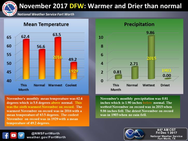 Meteorological Winter - Some of you have been wondering what Meteorological seasons means. These seasons are based off of the temperature change that usually takes place within these months in the season. For example, today marks the first day of winter, which runs through February 28. Then March 1 would mark the beginning of spring, then June 1 would be the start of summer. The difference between meteorological seasons and astronomical seasons is that astronomical seasons use the suns location in relation to Earth to determine the seasons. Cold? - Yes. A new surge of arctic air is due in the US by mostly the latter half of next week, which would obviously create frost and maybe some snow problems for some parts of the U.S. In North Texas, this will bring temperatures down into the mid 50s for highs and mid 30s for lows. Additionally, an arctic front will bring a chance of scattered showers and storms during the latter half of the week, potentially with some sleet in the mix.  The bottom line is, the coldest air of the season thus far arrives during the middle of next week. However, we do issue a word of caution... This type of weather typically awakens the “keyboard meteorologists” who loves to post voodoo blizzards that come from a deterministic computer run during the 10-16 day time frame. If you don’t know, most of these voodoo blizzards never show up, and is overall the worst possible way to forecast the weather. But these keyboard meteorologists do it simply for the clicks, likes, shares, and retweets. If you see of these posting these absurd model solutions, do us all a favor, and do not like, share, or retweet. Please also be aware of this before you or your friends post a deterministic model run on social media. Have a reliable source of getting accurate, up to date weather information.  |
AuthorWrite something about yourself. No need to be fancy, just an overview. Archives
June 2018
Categories |
 RSS Feed
