
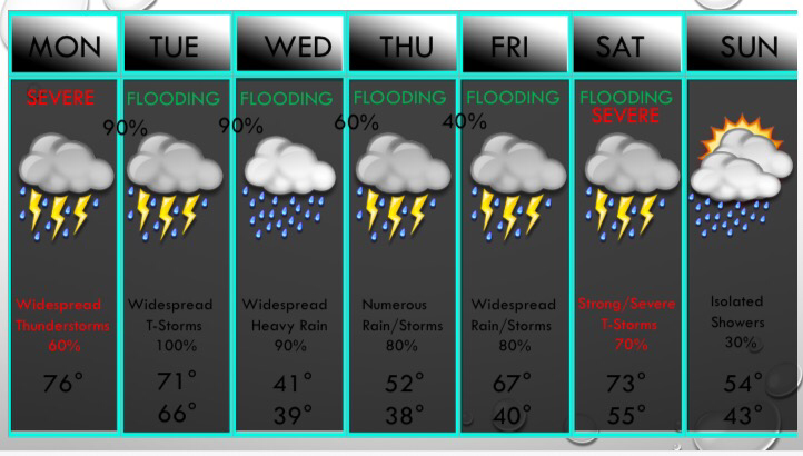
 Above is the UPDATED 7 Day Forecast:
A new Update on the seven day will be posted by 5PM. Severe Potential: Spotty showers continue in DFW because the cap is still holding any thunderstorm development to a minimum. Below are my concerns and thinking for this afternoon: Severe Potential: Scattered thunderstorms are expected to develop this afternoon, with near a 40-60% coverage of storms this afternoon. This coverage may be lower or higher than this number depending on many things: It's more likely to be higher than to be lower and here's why - The cap is something that suppresses thunderstorm development and it is still holding mainly strong at this time, but is a bit weaker than I anticipated. It is expected to continue to weaken and it may approach a breaking state. The instability also is increasing and is close to 1000 jKg at this time. I've noticed a few breaks in the clouds and sunshine will help us destabilize and have a higher instability value. So bottom line is that scattered to numerous thunderstorms are expected to develop, and they may turn severe. Large hail is likely to be the highest risk this afternoon, although damaging winds cannot be ruled out. This will NOT be a significant severe weather outbreak, but a few storms may turn severe. Stay up to date and keep an eye on the radar. The next timing on concern is overnight tonight as lift increases across North Texas and a complex of strong storms moves into DFW from the west/southwest. This will pose a heavy rain threat, but hail and strong winds will also be possible with this line. Hail sizes may reach as large as half dollar, and winds may reach up to 65mph. The tornado risk with this complex is not zero, but it's fairly low. And just like this afternoon, this will NOT be a major severe weather outbreak, but a few storms may turn severe with large hail and damaging winds. More widespread showers and thunderstorms will occur through the day tomorrow, with a very low risk of severe storms. Some small hail and gusty winds will be possible along with frequent lightning, but the primary risk will be very heavy rainfall that may lead to flash flooding. More widespread rain (possibly some freezing rain well northwest/west of DFW) will occur on Wednesday. Isolated rain is possible Thursday morning, but then widespread showers are likely during the afternoon hours continuing into Friday. Some severe weather is possible next Saturday across the eastern half of North Texas, including the DFW metroplex. -Jonathan |
AuthorWrite something about yourself. No need to be fancy, just an overview. Archives
June 2018
Categories |
 RSS Feed
