
 Welcome to the month of June, where meteorological and astronomical summer begin, respectively. If you do not know that there was ever a difference, here is some information from Scott Martin, a meteorologist in Central Alabama.
ASTRONOMICAL SUMMER: THURSDAY, JUNE 21ST – SATURDAY, SEPTEMBER 22ND The natural rotation of the Earth around the sun forms the basis for the astronomical calendar, in which we form the seasons by two solstices and two equinoxes. Earth’s tilt and the sun’s alignment over the equator determine both the solstices and equinoxes. Equinoxes mark when the sun passes directly over the equator, whereas solstices mark when the sun is farthest away from the equator. Since the Earth actually takes 365.24 days to travel around the sun, an extra day is needed every fourth year, creating “Leap Year.” This, along with the elliptical shape of the Earth’s orbit, makes the actual number of days in each season to vary between 89 to 93 days. This makes it difficult to compare climatological statistics consistently for a particular season from one year to next. That is why there is a need for meteorological seasons. METEOROLOGICAL SUMMER: FRIDAY, JUNE 1ST – FRIDAY, AUGUST 31ST Meteorologists and climatologists group the seasons in three month sections (or seasons) based on the calendar and on the annual temperature cycle. Forecasting and observing led to these seasons being created. Meteorological season length is more consistent between the four seasons as they are close to 90 days for each season. With less variation in start date and in season length, its much easier to calculate seasonal statistics from monthly statistics, both of which are very useful for agriculture, commerce, and a variety of other purposes. Now, let the June explanation begin. On average, June is the second warmest month of the year (go figure) featuring mostly hot temperatures with humidity staying at around normal levels for the summer. Contrary to popular belief, June is actually the second wettest month of the year in Dallas, right behind October. We usually average about 3.92 inches of rain during the month, but the wettest June on record saw 11.58 inches of rain back in 1928. For DFW airport, where records have been kept there for over 100 years, the wettest month there was June 2007, where 11.10 inches fell. Additionally, any tropical systems that happen to end up in Texas from the Gulf of Mexico has significantly shifted the rain total for the month in years past. June is also the second sunniest month of the year (on average), with a total of 23 days with possible sunshine. The average afternoon humidity starts to come down during the summer time months. 48% for the month of June, which is a decrease from the 53% in May. For the first day of June, the average high is about 88 degrees and the average low is 69. When we get to the end of the month, the average high increases to 95 and the average low increases to 75. The hottest high for June was observed on June 26 and 27, 1980, when we reached 105 degrees for the day. It has been as cold as 53 degrees for the morning low on June 1, 1982. As you may know, June 1st marks the first day of the Atlantic Hurricane Season, which stretches out until November 30. Two weeks ago, NOAA came out with their official hurricane season forecast, calling for a normal or above-normal season this year. More specifically, their thinking is that 10 to 16 tropical cyclones will end up named, 5 to 9 of those storms will intensify to hurricane strength, and 1 to 4 could intensify to even major hurricane status. Since Alberto was the first storm named this year, we will kick off the hurricane season on the second name when the time comes. We will have to wait and see if Beryl will form in the Gulf during the next week or so. 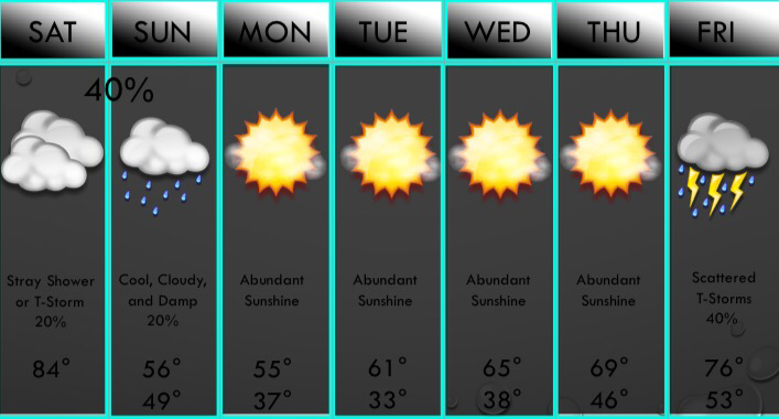 THIS WEEKEND: We will be very warm and humid today with clouds this morning, with some sun this afternoon, but clouds roll back in later this afternoon into the evening. As a cold front approaches, some storms will fire up along it especially east of I/35. A few may be strong to marginally severe with gusty winds and hail. A few stronger cells with 70mph winds and half dollar size hail are possible mainly east of DFW. Tornado risk is the DFW area is very low, but it is a little higher towards the Shreveport area. We will have some clouds and drizzle with us tomorrow, but a few models have widespread light rain and even a storm or two tomorrow so I will watch that, but leaving low chances for now.
NEXT WEEK: Chilly weather is with us on Monday, and lows will be near freezing. Sunshine will be in abundance Monday through Thursday with a gradual warming trend. Storm chances return on Friday. NEXT WEEKEND: It looks like we will have a decent shot of showers and storms Friday into Saturday. While it's too early to be certain, it does appear that there may be a severe risk, but it looks fairly low. Have a good day! ;) -Jonathan Its sunny and chilly out there with most locations in the lower 50s in DFW, and we will only reach the mid 50s this afternoon with feels like temperatures in the upper 40s with a light breeze. Some high clouds will stream in late this afternoon/evening, but no precipitation is expected. We will fall to the mid and upper 30s tonight with NO freezes expected in the DFW area, but a few outlying areas may approach the freezing mark. Some isolated frost is possible by tomorrow morning mainly N of the DFW area. Clouds will be in abundance tomorrow, with mostly cloudy to overcast skies expected throughout the day tomorrow with highs near 60° in the area, but western counties in the warmer advection may reach the upper 60s to near 70° in those areas. We will fall to the upper 40s and low 50s Friday with some morning sunshine, but we willl turn mostly cloudy near 10AM with spotty light drizzle possible south of I/20 where there will he better moisture. We will continue the cloudy trend into Saturday. As a dryline moves towards the I/35 corridor by Saturday afternoon, and widely scattered thunderstorms will develop. I don't expect much in the way of severe weather, but a few strong storms will gusty winds and small hail are possible mainly east of D/FW. Highs will be in the mid 70s across the region to near 80° west of DFW. We will fall to the 50s Sunday morning with only highs reaching the mid 60s on Sunday. Sunday will be mostly cloudy yet again across the area. Colder air comes in and we start Monday in the 30s, and only make it to the upper 40s and lower 50s across the area with partly sunny skies. Clouds move back in Tuesday with isolated rain west of Highway 281 possible. Highs will be in the upper 50s on Tuesday.
-Jonathan 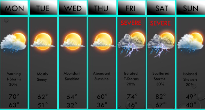 Above is your apexwx 7 day forecast!The clouds and scattered showers and rumbles of thunder have been with us this afternoon, and scattered showers will continue tonight, especially east of D/FW tonight. We will have some showers move into D/FW this evening, but most of the precip will be in East Texas by midnight. A weak cold front will move into the area mid morning tomorrow, and a few isolated showers and storms may develop along it mainly SE of D/FW. No severe weather is anticipated, and in fact, no strong storms are even in the forecast with very low instability amounts. The clouds will break up near midday but high clouds may move in during the day tomorrow. The forecast is partly sunny tomorrow afternoon. All clouds will clear the area tomorrow evening and night. The next cold front will move in Tuesday afternoon and it may bring clouds with it, but no rain or storms are anticipated at this time. We will clear out Tuesday evening and temperatures will fall into the lower 30s north of I/20 with upper 30s and lower 40s south of I/20 where cold air advection will be less impressive. Some frost will develop in D/FW and a freeze is possible, especially north of a line from Graham to D/FW to Sulphur Springs. We will warm to the mid 50s and upper 50s Wednesday afternoon with lower 60s in our southern zones. Sunshine will be in abundance through the day Wednesday. We will fall back into the mid 30s Thursday morning, with another freeze possible northwest of D/FW. We will reach the 60s Thursday afternoon. We will have highs back into the 70s on Friday with some weak lift and some instability. A few storms will be possible on Friday and a few may be severe. But, modest instability will limit the overall risk of severe weather on Friday. Most areas will just see some light rain on Friday, but again, a few storms may develop and may be strong to severe. A cold front and dryline will approach the area on Saturday and some thunderstorms may develop along these forcing mechanisms. At this time, the majority of the rain and storms will remain NE of the area, but this is 6 days away so models can still change their solutions. Either way, instability values will be high on Saturday and we will have a very volatile atmospheric set up. Therefore, any storms will likely pose a severe risk. We will closely watch this. Much colder air will filter in behind the front Saturday night and we could have winds gust in excess of 40mph Saturday night. A few showers are possible next Sunday with highs in the upper 40s and 50s across the area. All precip will exit the area late Sunday and a cold start to next week is plausible given the strong cold air advection in place, and more freezes appear possible during this timeframe. No wintry weather is anticipated at this time.
Have a blessed evening! ;) -Jonathan Williams The clouds have been widespread this morning and this trend will continue through the next 24-36 hours. Some drizzle is out there now, but scattered (40%) showers and thunderstorms will develop this afternoon. While severe weather is not expected, a few strong storms are possible producing gusty winds, heavy rain, small hail, frequent cloud to ground lightning, and very loud rumbles of thunder! Any (low) severe risk will remain well north of our area closer to the upper level system. A weak cold front will move in tonight, possibly with a skinny line of showers and storms along it. A few strong storms are possible, but severe weather is NOT expected. Some storms may produce brief heavy rain and gusty winds, however. All thunderstorms will push east of the area tomorrow morning, but clouds will hold very firm through the day tomorrow. We may see a hour or two of near midday, but clouds will roll in ahead of our next cold front by 2PM, so mostly cloudy weather will prevail. A few sprinkles are possible with this front, but no measurable precipitation is expected. I cannot completely rule out a shower or two, but coverage will remain less than 10%. Skies will clear late tomorrow night, but the cold air behind the front will be delayed. Highs will be in the mid 60s, but we will fall into the lower to mid 30s Tuesday night with another freeze possible, but we will only rebound to the mid to upper 50s Wednesday afternoon, with our western and southern counties reaching the 60s. We will fall back to near freezing Wednesday night, and we will reach the 60° mark by Thursday. Sunshine will continue to be the player from Tuesday to Thursday. Ahead of our next cold front/upper level system, clouds will return by Friday with widespread cloud cover and isolated showers and thunderstorms. With a dryline and a cold front along with a strong system, we will watch for severe weather to return by Saturday. CAPE values will be approaching 3,000 JKg and with strong shear, we will likely have a potential of rotating supercells Saturday afternoon and night. It's too early to tell which types of severe weather will be the primary risks, but all modes of severe weather including large hail, damaging winds, tornadoes, and flash flooding appear possible. This does have the potential to be our first significant severe weather event of the season. Thunderstorms will he scattered in nature Saturday afternoon, with a line of strong storms during the overnight hours. I'll keep you updated on this potential.
Planters: With frost and freezes back into the forecast this week, please abstain from planting anything. March still can be freezes and I do believe this may not be our last freezes, so again, please to not plant yet! I'll let you know when it is safe. Regarding the seven day forecast: I hope to have it uploaded today, and follow my twitter @apexwx2 for when I say it's been released. It's been a very busy week and I haven't had much time! If it's not uploaded today (and I plan to have it uploaded soon) it will be uploaded tomorrow! Have a blessed Sunday! ;) - Jonathan Williams Good evening, North Texas! Today was a beautiful day, but the clouds and drizzle have moved into the region. We will continue with these clouds and drizzle into the overnight, with a few isolated to scattered showers and possibly a thunderstorm developing overnight especially from Sherman to Dallas to Waco points westward. No severe storms are anticipated. Tomorrow morning will be warm and humid, with temperatures in the upper 50s and 60s in DFW, with upper 40s to near 50° in our eastern counties where clouds and precipitation will be less numerous. Clouds will cover all of the area by 7AM tomorrow, with spotty shower/storm activity around. A few more numerous areas of showers and thunderstorms will develop by tomorrow afternoon, with about 40-50% of North Texas picking up rainfall. While widespread severe weather isn't expected, a strong to possibly severe thunderstorm with hail and high winds cannot be ruled out. Heavy rain will be the primary hazard leading to localized flooding due to all the recent rainfall. By tomorrow evening, showers and storms will move out of DFW and we will be stuck with the clouds and light rain. Something that has caught my attention is the pacific cold front that will move into the area tomorrow night. The MU CAPE values (most unstable convective available potential energy) across the Dallas/Fort Worth area will be near 1000-1500 with surface based CAPE near 800-1200 across the area. With this being said, we anticipate a few storms to develop along this front late tomorrow night. With sufficient instability and shear, a few strong to severe thunderstorms are possible. The shear will be near 50kts which may support a few rotating cells, so we will monitor any low tornado potential. Only a 30% coverage of storms is expected, which may increase the overall severe risk with storms not fighting for energy which can weaken storms. The storms won't have to fight for energy so each cell could be on the stronger side. We will watch that closely. The best chance of storms will be EAST of DFW, but still a few isolated storms (possibly strong to severe) will be possible. Scattered storms will continue into Monday morning, but then rain moves out and we dry out during the afternoon, but sunshine may be hard to come by. Mostly cloudy skies will continue into the afternoon. Cooler air will penetrate into the region on Tuesday and Wednesday with highs in the low 60s on Tuesday, with mid to upper 50s on Wednesday, so grab that light jacket! You may want to coats during the morning with temperatures in the 30s with isolated 20s possible. We will reach 60° Thursday with sunshine continuing and the 70s by Friday. We will warm to near 80° by next Saturday with a chance of storms, some of which may be severe.
The 7 day forecast will be uploaded to the website before 12:00pm tomorrow. Sorry for the inconvenience the past few days, I've been very busy! -Jonathan Williams Good evening, North Texas! It was a very nice today, but the sunshine streak is coming to an end. Some scattered showers will develop overnight, and clouds and fog will quickly overspread the area. Some of the fog may be quite dense, so use caution on your commute! A few storms are possible in the morning, but widespread storms will develop by afternoon, and a few storms may be severe primarily with a hail threat. Gusty winds are possible, but tornadoes are not expected. By wednesday, everything becomes questioned. Let me break this down. If there's rain in the morning, any rain will be east of the area. If we cannot see much warming either we see rain or not, the severe risk and storm risk will be low. But, if there's no morning rain (in significance) there will be a severe threat and a potentially high coverage of storms, and we will need to see heating. All rain rain will exit the area late Wednesday night and Thursday-Saturday will be dry.
Another round of storms is expected by Sunday, and severe storms are possible. More on that later this week. Some colder air (highs in the 40s and 50s) will enter next Monday. There are signs that significant cold will return to North Texas by the end of next week. There are also signs of precipitation chances during the timeframe, so we will monitor any threat of winter weather. The seven day forecast will be uploaded to the website by 6:00 AM tomorrow. Have a great night! -Jonathan 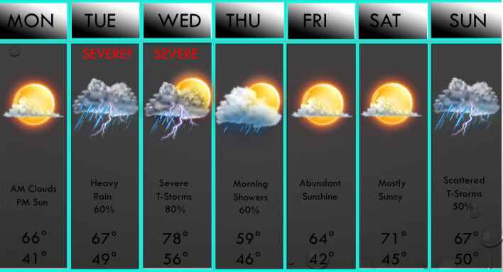 ABOVE IS YOUR 7 DAY FORECAST!The wet weather has come to an end, at least for tonight and tomorrow! The clouds will increase overnight as well as some fog developing. Some spotty very light rain or drizzle is possible tomorrow morning, but any precip will not be measureable, just enough to dampen the roads, but any very light rain will remain very spotty in nature. Clouds will decrease by midday with sunshine returning by afternoon with highs in the 60s. But, it should be noted that a few models have clouds staying around tomorrow afternoon, and it would keep highs in the upper 50s across the D/FW metroplex, but will leave it out of the forecast for now. If models bring more cloud cover, we will address that in the morning.
By tomorrow night, clouds will be in place with some scattered (20-30%) shower activity south of I/20. Some spotty storm activity is possible Tuesday morning, but thunderstorms will rapidly develop by midday. These storms will roll through the DFW area between 2PM-6PM, bringing pockets of very heavy rain, lightning, gusty winds, hail up to quarter size, and isolated instances of flash flooding. The overall chance of severe storms on Tuesday appears low, but a few isolated embedded severe storms are possible. Storms will exit our area Tuesday night, but scattered to numerous storms will develop Wednesday morning. A few marginally severe storms are possible, but most storms will remain behaved Wednesday morning. By afternoon, a dryline and a cold front will begin to approach the area from the west and northwest. A squall line of strong to possibly severe thunderstorms will develop and push east and southeast and affect the Dallas/Fort Worth area near 9-10PM. Large hail and damaging winds are possible along the leading edge of the thunderstorms. I cannot even rule out a tornado or two as well. After the leading edge passes through, things will turn from a severe threat to a heavy rain threat for the overnight hours, and flash flooding will then become a concern. 1-3" of additional rainfall could fall during the overnight hours. Scattered rain showers and possibly a thunderstorm will linger into Thursday morning east of I/35, but sunshine will return to all areas by afternoon. Use caution on your Thursday morning commute and keep an eye out for any remaining flooded areas. We will dry out completely late in the day through Saturday! But yet again, a good chance of storms may occur next Sunday. The GFS keeps us dry on Sunday, so I lowered the chance of rain to only 50% and if the other models keep us drier, then will lower chances accordingly. My concerns go up next Monday as high instability values return ahead of our next cold front, and another severe weather event may occur. Colder air may move in next Tuesday will highs back in the 50s. Something that has caught my attention is that GEFS ensembles and the operational GFS have a blast of very cold air by the end of next week with widespread precipitation, leading to a wintry mix across the entire area later next week. We will closely watch all of these interesting weather features throughout the next 10 days, as we have a lot going on! -Jonathan Today has been a quiet day in the D/FW area, and temperatures are pleasant in the 60s! Tomorrow will likely be a repeat of today, with sunshine and highs in the 60s. As moisture returns during the afternoon, a few clouds may roll in, and a brief shower or storm cannot be ruled out, mainly towards the Brazos Valley. But, changes come back midweek, with rain/storms making a comeback! What days will the rain come? The chances of rain tomorrow are scarce to none, but high rain chances return Tuesday and Wednesday, and a few lingering showers or storms are possible early Thursday morning E/SE of the Dallas/Fort Worth area. Any severe threats? Yes, there are severe potentials, with the main threat on Wednesday. Tuesday afternoon as a round of storms moves in, a storm could turn strong to severe with hail as the main threat. Because of this, the Storm Prediction has placed all of North Texas under a marginal risk, and a slight risk is possible by the time we get to Tuesday. Again the primary threat is large hail up to the size of half dollars to golf balls. The wind/tornado threat on Tuesday is very low, but not zero. Heading into Wednesday, this is our main severe weather day, and because of this, we urge you to stay up to date and keep up with the latest conditions on twitter, @wx_dfw and @apex_wx_dfw as frequent updates and watches/warnings will be posted on Wednesday afternoon. A cold front will approach the CWA during the afternoon hours on Wednesday, and will fire up strong to severe thunderstorms, possibly producing large hail, damaging winds, and a tornado or two, especially east of I/35. (including the DFW metroplex) The instability amounts will not be extremely high, but it is enough to warrant a Severe Potential, and strong shear will aid in producing these storms. Lapse rates will support hail sizes up to the size of golf balls to baseballs, so please stay weather aware. Frequent updates through the next several days will address these potentials. How much rain will fall? Will flooding be an issue? These storms on Tuesday-Wednesday will be very heavy rain producers, and amounts of 1-3" are expected, with isolated higher amounts up to 5" are possible. Because of the ALL the rain we've seen in the past week, soils will be very saturated, so flash flooding will become an issue. A flash flood watch may be issued by the National Weather Service tomorrow, and I'll update you on IF and when any watches are issued. Should I go and cancel my plans on Tuesday and Wednesday? There are very high rain chances on these days (80%) but I would not go cancel plans on these days, mainly if they are in the morning. Tuesday and Wednesday morning will be mainly dry, but an isolated storm or two is possible. If you have any afternoon or evening plans, have plan B ready to go, because after midday these days rain chances will be very high. Remember, even i it isn't raining, flooded areas are still possible, and if it's not storming, lightning can strike well away from any storms, so please make safe decisions. After Thursday morning, things will dry out across all of North Texas, and we will be dry during the afternoon with sunshine breaking out. Plenty of sunshine will be with us on Friday and Saturday, but good rain and storm chances return next Sunday. There will likely be more showers & storms next Monday and Tuesday. While it's too early to get into any specifics, strong to severe storms appear at least possible during the timeframe, and flooding may be an issue due to all the rain we've seen. I'll update you on these potentials as we get closer to these events. As we have discussed a lot about recently, winter weather may make a harsh return in March. Negaitive NAO & AO will make for much colder air to return to the United States, after a well deserved break. We had a very harsh January, with lows in the single digits with several minor winter weather events. Last year, we had 2 days with below freezing temperatures, and this year we have had 10+ days! This year has been a chilly winter, and we've had more winter events than 2016 and 2017 combined, but most of them have had only minor accumulations and impacts, except for the January 15-16th event with some areas east of D/FW seeing up to 5" of sleet/snow! More events could occur in March, and I'll update you as soon as I can whenever the models have winter weather in the near future. Attached below is your updated seven day forecast! Have a great rest of your Sunday DFW! -Jonathan 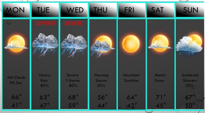 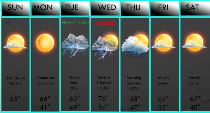 ABOVE IS YOUR UPDATED 7 DAY FORECAST!Today will be RAIN-free across the D/FW area, but areas towards Tyler to Athens have a slight chance of a pop-up thunderstorm, so if you are along and south of the I/20 corridor, there's a 10% chance of a storm, which chances increasing to 60% down towards the ATX metropolitan area, and near 90% in Houston. But again, DFW will be dry this afternoon. A few cumulus clouds may develop this afternoon, which is fairly rare in the winter time! We had some stratocumulus clouds yesterday, but they were not cumulus. Today will have a mix of sunshine, stratocumulus, and cumulus clouds across the D/FW area with a few high clouds possible. RAIN RETURNS MIDWEEK: Scattered thunderstorms are expected Tuesday morning WEST of I/35, but numerous thunderstorms will move in near midday, some strong to severe, and widespread storms will continue through the afternoon on Tuesday. A few may be severe with large hail and gusty winds, but the tornado threat is very low, but not zero. T-Storms will exit the D/FW area during the overnight hours, but scattered thunderstorms will develop in the D/FW area during the morning hours Wednesday, some severe with hail & high winds, but the main severe risk comes in the afternoon. Widespread thunderstorms will develop ahead of a pacific cold front, and these storms may turn severe with large hail, damaging winds, and isolated tornadoes. Stay up to date as the amounts of instability are still in question, so will hold off on saying whether there will be enough severe weather to aid a WATCH due to these uncertainties. Morning showers Thursday morning will give away to mostly sunny skies during the afternoon, and sunshine will be in abundance next weekend with mild temperatures prevailing. Regarding Winter Weather Potentials: The signs of winter weather are getting stronger in early March, and the models are really latching into it. What we do in these situations is look at Ocean Oscillations and we primary look at NAO ans AO. When these two features turn strongly negative, then concerns for cold air go up. We will have a quiet pattern through the 5th of March, then we will likely turn cold and wet. This may lead to at least a chance of winter weather. -Jonathan Williams |
AuthorWrite something about yourself. No need to be fancy, just an overview. Archives
June 2018
Categories |
 RSS Feed