
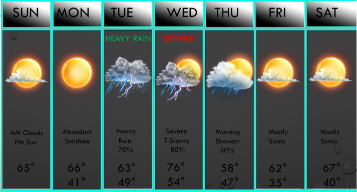
 ABOVE IS YOUR UPDATED 7 DAY FORECAST!Today will be RAIN-free across the D/FW area, but areas towards Tyler to Athens have a slight chance of a pop-up thunderstorm, so if you are along and south of the I/20 corridor, there's a 10% chance of a storm, which chances increasing to 60% down towards the ATX metropolitan area, and near 90% in Houston. But again, DFW will be dry this afternoon. A few cumulus clouds may develop this afternoon, which is fairly rare in the winter time! We had some stratocumulus clouds yesterday, but they were not cumulus. Today will have a mix of sunshine, stratocumulus, and cumulus clouds across the D/FW area with a few high clouds possible. RAIN RETURNS MIDWEEK: Scattered thunderstorms are expected Tuesday morning WEST of I/35, but numerous thunderstorms will move in near midday, some strong to severe, and widespread storms will continue through the afternoon on Tuesday. A few may be severe with large hail and gusty winds, but the tornado threat is very low, but not zero. T-Storms will exit the D/FW area during the overnight hours, but scattered thunderstorms will develop in the D/FW area during the morning hours Wednesday, some severe with hail & high winds, but the main severe risk comes in the afternoon. Widespread thunderstorms will develop ahead of a pacific cold front, and these storms may turn severe with large hail, damaging winds, and isolated tornadoes. Stay up to date as the amounts of instability are still in question, so will hold off on saying whether there will be enough severe weather to aid a WATCH due to these uncertainties. Morning showers Thursday morning will give away to mostly sunny skies during the afternoon, and sunshine will be in abundance next weekend with mild temperatures prevailing. Regarding Winter Weather Potentials: The signs of winter weather are getting stronger in early March, and the models are really latching into it. What we do in these situations is look at Ocean Oscillations and we primary look at NAO ans AO. When these two features turn strongly negative, then concerns for cold air go up. We will have a quiet pattern through the 5th of March, then we will likely turn cold and wet. This may lead to at least a chance of winter weather. -Jonathan Williams |
AuthorWrite something about yourself. No need to be fancy, just an overview. Archives
June 2018
Categories |
 RSS Feed
