
|
Today has been a quiet day in the D/FW area, and temperatures are pleasant in the 60s! Tomorrow will likely be a repeat of today, with sunshine and highs in the 60s. As moisture returns during the afternoon, a few clouds may roll in, and a brief shower or storm cannot be ruled out, mainly towards the Brazos Valley. But, changes come back midweek, with rain/storms making a comeback! What days will the rain come? The chances of rain tomorrow are scarce to none, but high rain chances return Tuesday and Wednesday, and a few lingering showers or storms are possible early Thursday morning E/SE of the Dallas/Fort Worth area. Any severe threats? Yes, there are severe potentials, with the main threat on Wednesday. Tuesday afternoon as a round of storms moves in, a storm could turn strong to severe with hail as the main threat. Because of this, the Storm Prediction has placed all of North Texas under a marginal risk, and a slight risk is possible by the time we get to Tuesday. Again the primary threat is large hail up to the size of half dollars to golf balls. The wind/tornado threat on Tuesday is very low, but not zero. Heading into Wednesday, this is our main severe weather day, and because of this, we urge you to stay up to date and keep up with the latest conditions on twitter, @wx_dfw and @apex_wx_dfw as frequent updates and watches/warnings will be posted on Wednesday afternoon. A cold front will approach the CWA during the afternoon hours on Wednesday, and will fire up strong to severe thunderstorms, possibly producing large hail, damaging winds, and a tornado or two, especially east of I/35. (including the DFW metroplex) The instability amounts will not be extremely high, but it is enough to warrant a Severe Potential, and strong shear will aid in producing these storms. Lapse rates will support hail sizes up to the size of golf balls to baseballs, so please stay weather aware. Frequent updates through the next several days will address these potentials. How much rain will fall? Will flooding be an issue? These storms on Tuesday-Wednesday will be very heavy rain producers, and amounts of 1-3" are expected, with isolated higher amounts up to 5" are possible. Because of the ALL the rain we've seen in the past week, soils will be very saturated, so flash flooding will become an issue. A flash flood watch may be issued by the National Weather Service tomorrow, and I'll update you on IF and when any watches are issued. Should I go and cancel my plans on Tuesday and Wednesday? There are very high rain chances on these days (80%) but I would not go cancel plans on these days, mainly if they are in the morning. Tuesday and Wednesday morning will be mainly dry, but an isolated storm or two is possible. If you have any afternoon or evening plans, have plan B ready to go, because after midday these days rain chances will be very high. Remember, even i it isn't raining, flooded areas are still possible, and if it's not storming, lightning can strike well away from any storms, so please make safe decisions. After Thursday morning, things will dry out across all of North Texas, and we will be dry during the afternoon with sunshine breaking out. Plenty of sunshine will be with us on Friday and Saturday, but good rain and storm chances return next Sunday. There will likely be more showers & storms next Monday and Tuesday. While it's too early to get into any specifics, strong to severe storms appear at least possible during the timeframe, and flooding may be an issue due to all the rain we've seen. I'll update you on these potentials as we get closer to these events. As we have discussed a lot about recently, winter weather may make a harsh return in March. Negaitive NAO & AO will make for much colder air to return to the United States, after a well deserved break. We had a very harsh January, with lows in the single digits with several minor winter weather events. Last year, we had 2 days with below freezing temperatures, and this year we have had 10+ days! This year has been a chilly winter, and we've had more winter events than 2016 and 2017 combined, but most of them have had only minor accumulations and impacts, except for the January 15-16th event with some areas east of D/FW seeing up to 5" of sleet/snow! More events could occur in March, and I'll update you as soon as I can whenever the models have winter weather in the near future. Attached below is your updated seven day forecast! Have a great rest of your Sunday DFW! -Jonathan 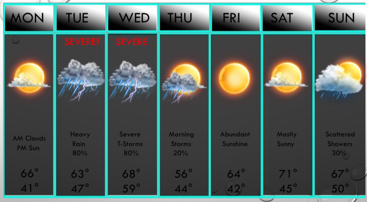 |
AuthorWrite something about yourself. No need to be fancy, just an overview. Archives
June 2018
Categories |
 RSS Feed
