
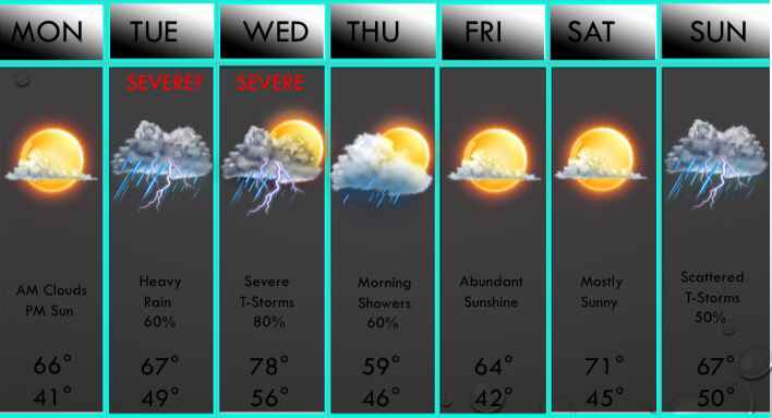
 ABOVE IS YOUR 7 DAY FORECAST!The wet weather has come to an end, at least for tonight and tomorrow! The clouds will increase overnight as well as some fog developing. Some spotty very light rain or drizzle is possible tomorrow morning, but any precip will not be measureable, just enough to dampen the roads, but any very light rain will remain very spotty in nature. Clouds will decrease by midday with sunshine returning by afternoon with highs in the 60s. But, it should be noted that a few models have clouds staying around tomorrow afternoon, and it would keep highs in the upper 50s across the D/FW metroplex, but will leave it out of the forecast for now. If models bring more cloud cover, we will address that in the morning.
By tomorrow night, clouds will be in place with some scattered (20-30%) shower activity south of I/20. Some spotty storm activity is possible Tuesday morning, but thunderstorms will rapidly develop by midday. These storms will roll through the DFW area between 2PM-6PM, bringing pockets of very heavy rain, lightning, gusty winds, hail up to quarter size, and isolated instances of flash flooding. The overall chance of severe storms on Tuesday appears low, but a few isolated embedded severe storms are possible. Storms will exit our area Tuesday night, but scattered to numerous storms will develop Wednesday morning. A few marginally severe storms are possible, but most storms will remain behaved Wednesday morning. By afternoon, a dryline and a cold front will begin to approach the area from the west and northwest. A squall line of strong to possibly severe thunderstorms will develop and push east and southeast and affect the Dallas/Fort Worth area near 9-10PM. Large hail and damaging winds are possible along the leading edge of the thunderstorms. I cannot even rule out a tornado or two as well. After the leading edge passes through, things will turn from a severe threat to a heavy rain threat for the overnight hours, and flash flooding will then become a concern. 1-3" of additional rainfall could fall during the overnight hours. Scattered rain showers and possibly a thunderstorm will linger into Thursday morning east of I/35, but sunshine will return to all areas by afternoon. Use caution on your Thursday morning commute and keep an eye out for any remaining flooded areas. We will dry out completely late in the day through Saturday! But yet again, a good chance of storms may occur next Sunday. The GFS keeps us dry on Sunday, so I lowered the chance of rain to only 50% and if the other models keep us drier, then will lower chances accordingly. My concerns go up next Monday as high instability values return ahead of our next cold front, and another severe weather event may occur. Colder air may move in next Tuesday will highs back in the 50s. Something that has caught my attention is that GEFS ensembles and the operational GFS have a blast of very cold air by the end of next week with widespread precipitation, leading to a wintry mix across the entire area later next week. We will closely watch all of these interesting weather features throughout the next 10 days, as we have a lot going on! -Jonathan |
AuthorWrite something about yourself. No need to be fancy, just an overview. Archives
June 2018
Categories |
 RSS Feed
