
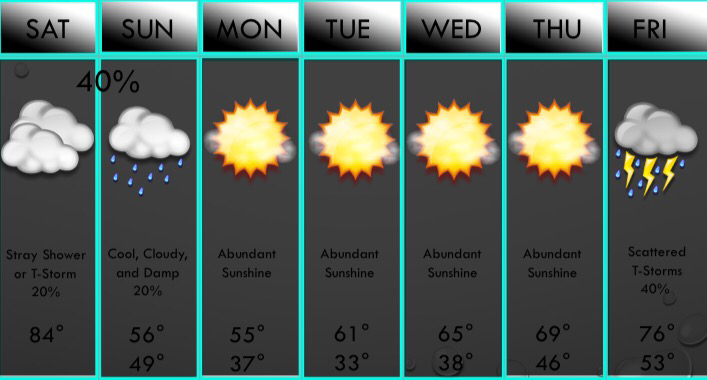
 THIS WEEKEND: We will be very warm and humid today with clouds this morning, with some sun this afternoon, but clouds roll back in later this afternoon into the evening. As a cold front approaches, some storms will fire up along it especially east of I/35. A few may be strong to marginally severe with gusty winds and hail. A few stronger cells with 70mph winds and half dollar size hail are possible mainly east of DFW. Tornado risk is the DFW area is very low, but it is a little higher towards the Shreveport area. We will have some clouds and drizzle with us tomorrow, but a few models have widespread light rain and even a storm or two tomorrow so I will watch that, but leaving low chances for now.
NEXT WEEK: Chilly weather is with us on Monday, and lows will be near freezing. Sunshine will be in abundance Monday through Thursday with a gradual warming trend. Storm chances return on Friday. NEXT WEEKEND: It looks like we will have a decent shot of showers and storms Friday into Saturday. While it's too early to be certain, it does appear that there may be a severe risk, but it looks fairly low. Have a good day! ;) -Jonathan |
AuthorWrite something about yourself. No need to be fancy, just an overview. Archives
June 2018
Categories |
 RSS Feed
