
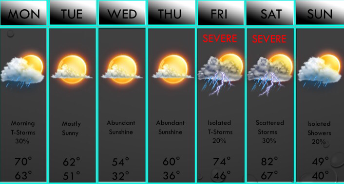
 Above is your apexwx 7 day forecast!The clouds and scattered showers and rumbles of thunder have been with us this afternoon, and scattered showers will continue tonight, especially east of D/FW tonight. We will have some showers move into D/FW this evening, but most of the precip will be in East Texas by midnight. A weak cold front will move into the area mid morning tomorrow, and a few isolated showers and storms may develop along it mainly SE of D/FW. No severe weather is anticipated, and in fact, no strong storms are even in the forecast with very low instability amounts. The clouds will break up near midday but high clouds may move in during the day tomorrow. The forecast is partly sunny tomorrow afternoon. All clouds will clear the area tomorrow evening and night. The next cold front will move in Tuesday afternoon and it may bring clouds with it, but no rain or storms are anticipated at this time. We will clear out Tuesday evening and temperatures will fall into the lower 30s north of I/20 with upper 30s and lower 40s south of I/20 where cold air advection will be less impressive. Some frost will develop in D/FW and a freeze is possible, especially north of a line from Graham to D/FW to Sulphur Springs. We will warm to the mid 50s and upper 50s Wednesday afternoon with lower 60s in our southern zones. Sunshine will be in abundance through the day Wednesday. We will fall back into the mid 30s Thursday morning, with another freeze possible northwest of D/FW. We will reach the 60s Thursday afternoon. We will have highs back into the 70s on Friday with some weak lift and some instability. A few storms will be possible on Friday and a few may be severe. But, modest instability will limit the overall risk of severe weather on Friday. Most areas will just see some light rain on Friday, but again, a few storms may develop and may be strong to severe. A cold front and dryline will approach the area on Saturday and some thunderstorms may develop along these forcing mechanisms. At this time, the majority of the rain and storms will remain NE of the area, but this is 6 days away so models can still change their solutions. Either way, instability values will be high on Saturday and we will have a very volatile atmospheric set up. Therefore, any storms will likely pose a severe risk. We will closely watch this. Much colder air will filter in behind the front Saturday night and we could have winds gust in excess of 40mph Saturday night. A few showers are possible next Sunday with highs in the upper 40s and 50s across the area. All precip will exit the area late Sunday and a cold start to next week is plausible given the strong cold air advection in place, and more freezes appear possible during this timeframe. No wintry weather is anticipated at this time.
Have a blessed evening! ;) -Jonathan Williams |
AuthorWrite something about yourself. No need to be fancy, just an overview. Archives
June 2018
Categories |
 RSS Feed
