
 For the North Atlantic...Caribbean Sea and the Gulf of Mexico:
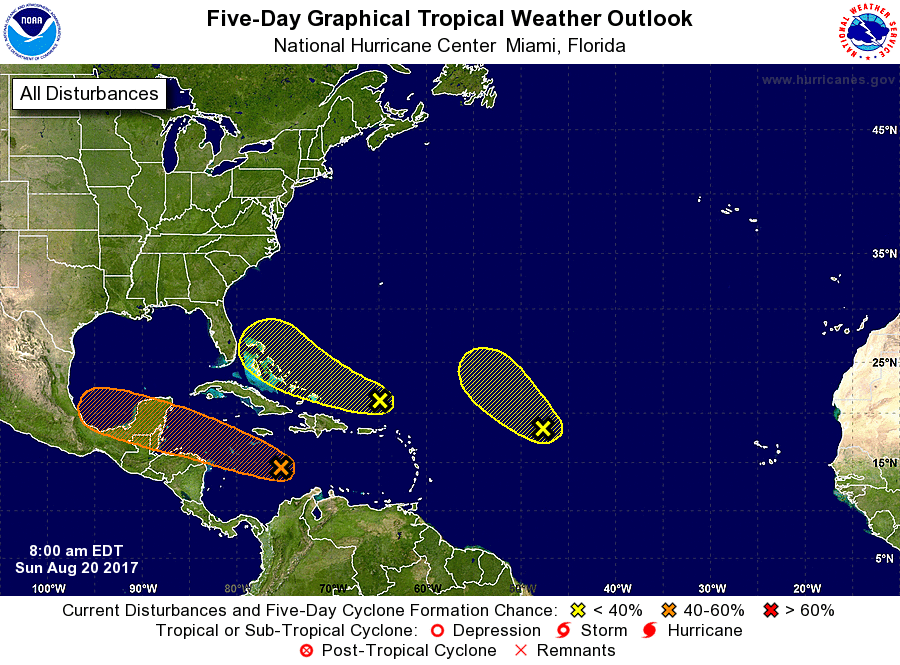
1. Showers and thunderstorms have increased this morning in association with the remnants of Harvey. Gradual development of this system is possible, and it could become a tropical cyclone once again as it moves west-northwestward across the central and northwestern Caribbean Sea during the next couple of days. Interests in northern Nicaragua, Honduras, Belize, and the Yucatan peninsula should monitor the progress of this system. An Air Force Reserve reconnaissance aircraft is scheduled to investigate this disturbance later today. * Formation chance through 48 hours...medium...50 percent * Formation chance through 5 days...medium...60 percent 2. A trough of low pressure located a couple of hundred miles north of Puerto Rico continues to produce disorganized showers and thunderstorms. Environmental conditions are expected to be unfavorable for development of this system during the next couple of days, but they could become slightly more conducive for development by midweek when the system is near the northwestern Bahamas or Florida. * Formation chance through 48 hours...low...10 percent. * Formation chance through 5 days...low...20 percent. 3. A large area of cloudiness and disorganized thunderstorms located about 1000 miles east of the northern Leeward Islands is associated with a trough of low pressure. This system is currently embedded in a dry air mass, and upper-level winds are expected to become too strong to support development in a day or so. Therefore, tropical cyclone formation is not likely while this system moves northwestward at about 15 mph. * Formation chance through 48 hours...low...10 percent. * Formation chance through 5 days...low...10 percent. For the North Atlantic...Caribbean Sea and the Gulf of Mexico: 1. Showers and thunderstorms are showing some signs of organization in association with a strong tropical wave located over the west-central Caribbean Sea. This system is moving west-northwestward at 10 to 15 mph, and a tropical depression or tropical storm could form over the northwestern Caribbean Sea before it reaches the Yucatan Peninsula of Mexico late Monday or early Tuesday. Even if formation does not occur before the system reaches the Yucatan peninsula, a tropical depression or tropical storm could form over the Bay of Campeche by midweek. The Air Force Reserve reconnaissance aircraft scheduled for today has been canceled, but a new mission has been scheduled for Monday, if necessary. Interests along the coasts of Honduras, Belize, and the Yucatan Peninsula should monitor the progress of this disturbance. * Formation chance through 48 hours...medium...60 percent. * Formation chance through 5 days...high...80 percent. 2. An area of low pressure located about midway between the Cabo Verde Islands and the Lesser Antilles remains elongated, and the associated showers and thunderstorms are not well organized. Some slow development of this system is possible during the next several days while it moves generally west-northwestward across the tropical Atlantic at about 15 mph. * Formation chance through 48 hours...low...30 percent. * Formation chance through 5 days...medium...50 percent. 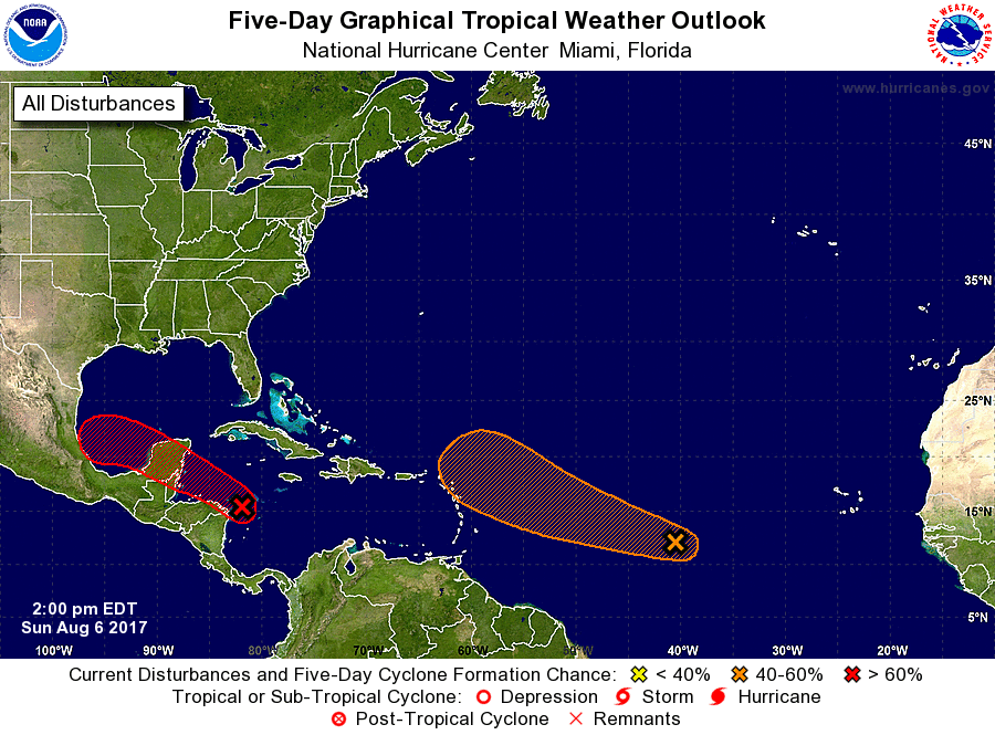 |
Archives
October 2018
Categories |
 RSS Feed
